psuhoffman
-
Posts
27,419 -
Joined
-
Last visited
Content Type
Profiles
Blogs
Forums
American Weather
Media Demo
Store
Gallery
Everything posted by psuhoffman
-

Feb Long Range Discussion (Day 3 and beyond) - MERGED
psuhoffman replied to WinterWxLuvr's topic in Mid Atlantic
The GEFS does agree with the op wrt the stronger NS wave then suppressed southern wave solution for the 25/26. But it actually trended north with the threat around the 28. So much so that more misses are to the north then south with that wave. Which makes sense it would hurt more to miss one storm to the south and one to the north back to back. Lol. -
January Storm Term Threat Discussions (Day 3 - Day 7)
psuhoffman replied to WxUSAF's topic in Mid Atlantic
That’s a NS wave though. I’m talking about the 3 southern stream waves back around the 9th/12th/14th and then the ones around the 18th/22nd. Every single southern stream dominant wave has been squashed since around New Years. NS waves are different Imo. Some of those have amplified but that’s not going to do us much good because without any real arctic cold around it’s highly doubtful a NS dominant wave can track under us. We need a southern stream wave to amplify and come at us from the south. They have all been shredded since the block set in. -
January Storm Term Threat Discussions (Day 3 - Day 7)
psuhoffman replied to WxUSAF's topic in Mid Atlantic
I lasted a LOT longer then Ji!!!! -
January Storm Term Threat Discussions (Day 3 - Day 7)
psuhoffman replied to WxUSAF's topic in Mid Atlantic
Sheet what we even doing here. -
January Storm Term Threat Discussions (Day 3 - Day 7)
psuhoffman replied to WxUSAF's topic in Mid Atlantic
I just posted in the other thread about this...I still favor the euro for the reasons you said plus the cmc/geps is the tie breaker...but at the same time I won’t lie it bugs me to see all the southern stream waves next week suddenly get squashed at about the same range that’s been happening to every one of them since the NAO went strongly negative almost 3 weeks ago. -
Feb Long Range Discussion (Day 3 and beyond) - MERGED
psuhoffman replied to WinterWxLuvr's topic in Mid Atlantic
There are good reasons to doubt the gfs/gefs since its handling one feature differently then all other guidance. But...there is also this. Remember the first strong NAO block 2 weeks ago from 200+ hours out we were worried about a string of cutters. All 3 of those waves ended up weak pathetic squashed waves that didn’t get close to us. And they all shifted south at about 150-200 hours. Then...this is what the wave this week looked like when it was 8 days out. and then at day 6/7 it shifted to this... so one thing arguing for this gfs solution is the undeniable seasonal trend. Just laying all the cards on the table. Still think it’s wrong. But I’ve always been more worried about suppressed then a cutter so seeing it suddenly squash everything at the same magic threshold that’s happened to every wave since the NAO tanked 3 weeks ago wasn’t a warm fuzzy feeling either. -
Feb Long Range Discussion (Day 3 and beyond) - MERGED
psuhoffman replied to WinterWxLuvr's topic in Mid Atlantic
Cold doesn’t cause suppression. I was in New England and it was snowing near 0 once. The flow suppresses. Often the two are related and correlated because a suppression means the flow is from the north typically and that in winter usually means cold. But if it’s warm all the way to the Arctic circle like now...it doesn’t matter what direction our air is coming from. But a north flow will still press a storm south. I’m simplifying this a little and leaving out things like shear and compression but that’s the general idea. -
Feb Long Range Discussion (Day 3 and beyond) - MERGED
psuhoffman replied to WinterWxLuvr's topic in Mid Atlantic
Fixed -
January Storm Term Threat Discussions (Day 3 - Day 7)
psuhoffman replied to WxUSAF's topic in Mid Atlantic
You mean it didn’t...I’m sure it will in 2 hours! -
January Storm Term Threat Discussions (Day 3 - Day 7)
psuhoffman replied to WxUSAF's topic in Mid Atlantic
What is this BS!!!!! Closed upper low tracking south of us in prime climo and rain to upstate NY!!!! -
January Storm Term Threat Discussions (Day 3 - Day 7)
psuhoffman replied to WxUSAF's topic in Mid Atlantic
But it gives SC a historic snowstorm. We are all fine with getting absolutely no snow out of this whole pattern so they can get a blizzard right? Right... -
January Storm Term Threat Discussions (Day 3 - Day 7)
psuhoffman replied to WxUSAF's topic in Mid Atlantic
I think each wave starts further south. But the 3rd wave has some room to amplify and gain latitude on the coast. Not a lot. Depends how it interacts with the NS. But that’s the only one that imo could push snow north after it starts east of the mountains. -
January Storm Term Threat Discussions (Day 3 - Day 7)
psuhoffman replied to WxUSAF's topic in Mid Atlantic
They all have it but they shear it out running into the block way faster then the gfs. That preserves our temps but also leaves room/energy for wave 2 to amplify. It’s a win win. A stronger NS front runner is a lose lose. Worse temps and weaker 2nd wave. -
Feb Long Range Discussion (Day 3 and beyond) - MERGED
psuhoffman replied to WinterWxLuvr's topic in Mid Atlantic
It’s the only guidance still keying on the front running NS wave so much. That messes up the wave for the 26th. Then (not that by then it matters if it’s wrong with waves 1-2) it’s faster then all other guidance with the 3rd wave so it’s too close to wave 2 and washes out. I’d toss but it does fit the pattern of fail recently so I won’t say it’s not possible. -
It’s still taking too much energy with the front runner wave which messes up everything behind it. Doubt it’s right. But who knows we are on an epic run of fail.
-
January Storm Term Threat Discussions (Day 3 - Day 7)
psuhoffman replied to WxUSAF's topic in Mid Atlantic
That’s just the NS front runner. Gfs looks about to suppress everything of importance. Lol. I’m way more worried about everything getting suppressed then I am missing to the north next week. The only wave that will go north Imo is the weak front running NS wave. The 2 waves after that 26th and 28/29 will either be a hit or suppressed imo. -
January Storm Term Threat Discussions (Day 3 - Day 7)
psuhoffman replied to WxUSAF's topic in Mid Atlantic
That was during my last semester at PSU. Actually my second stint, I took some time off after I was in a bad ski accident in 2000 and then changed majors. But I was home most weekends working shifts at TGI Fridays in Herndon to make cash. I remember driving through the snow from the front runner wave on the way down. Then went to a movie with an old friend that night and it was freezing cold just before the second wave. The next day drive back to PSU in the snow took like 8 hours. -
Feb Long Range Discussion (Day 3 and beyond) - MERGED
psuhoffman replied to WinterWxLuvr's topic in Mid Atlantic
That was the mess the gfs was showing the other day when it was dumping everything west and punching a ridge to the North Pole (not exaggerating lol) ahead of it. -
Feb Long Range Discussion (Day 3 and beyond) - MERGED
psuhoffman replied to WinterWxLuvr's topic in Mid Atlantic
I wasn’t poking at you. But I’ve said for a while I think the mjo is symbiotic. It’s part of the big picture. And often if it’s a strong signal it does align with the pattern. But sometimes when other things are driving the bus a weak mjo signal won’t offset. It’s failed to save us in bad patterns and it’s failed to kill us in good ones. But there are like 800 correlations to each little variable and what this phase does in that solar or this qbo and when there is a full moon with a vampire attack. I dunno how you use all that crap. -
Feb Long Range Discussion (Day 3 and beyond) - MERGED
psuhoffman replied to WinterWxLuvr's topic in Mid Atlantic
The mjo looks kinda sorta goodish but bad except when there is a west wind then it’s ok so long as it’s not WNW but if the AAM is low then maybe but definitely not bad or good when the qbo is west but east is ok unless the solar is high then you need a SSW but only if it couples and not too strongly or else you need the PDO or TNH. Chuck can explain. -
January Storm Term Threat Discussions (Day 3 - Day 7)
psuhoffman replied to WxUSAF's topic in Mid Atlantic

-
Feb Long Range Discussion (Day 3 and beyond) - MERGED
psuhoffman replied to WinterWxLuvr's topic in Mid Atlantic
Fwiw geps likes the idea of a groundhogs day storm also -
January Storm Term Threat Discussions (Day 3 - Day 7)
psuhoffman replied to WxUSAF's topic in Mid Atlantic
I was in 12” last night...call it all off -
Feb Long Range Discussion (Day 3 and beyond) - MERGED
psuhoffman replied to WinterWxLuvr's topic in Mid Atlantic
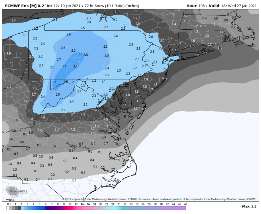
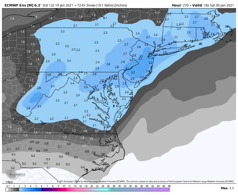
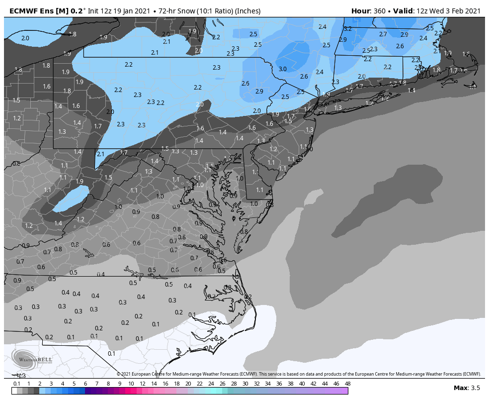
@frd there are 3 distinct threats on the EPS. First is discussed in the day 3-7 thread. This frame captures the day 9-11 threat. I’ve covered this. It’s the one I’ve thought had the most potential to be a big storm. I’m not kicking the otters out of bed though. EPS tees up another wave for groundhogs day. Questionable on thermals by then but it’s not a bad signal. It certainly favors the northern parts more but there are enough members with a far enough south track to watch. The setup is there..can see the energy being forced under the block. Ridge is suppressed. Would depend on how much and where the cold boundary is setup probably.

-
January Storm Term Threat Discussions (Day 3 - Day 7)
psuhoffman replied to WxUSAF's topic in Mid Atlantic
Some members have a slower second wave. This frame captures the whole event across all members without any contamination with the 28/29 threat yet.