

psuhoffman
-
Posts
27,419 -
Joined
-
Last visited
Content Type
Profiles
Blogs
Forums
American Weather
Media Demo
Store
Gallery
Everything posted by psuhoffman
-

December 2021 Medium/Long Range Discussion Thread
psuhoffman replied to North Balti Zen's topic in Mid Atlantic
I would love for the two waves before and during Xmas to work but their long shots. But the guidance is turning that Xmas wave into a monster 50/50 and preserving the west based block. If that’s accurate look for the period after that for a legit threat. Any legit wave would have a good chance. -
December 2021 Medium/Long Range Discussion Thread
psuhoffman replied to North Balti Zen's topic in Mid Atlantic
It wasn’t AWFUL but 15.6” total (considering bwi climo was ~ 22” during that period) with that pattern would have been a let down. It was also worse up here. Low 20s I think which is a bottom 10% snowfall winter here. Cold/dry if my memory of the records is right. Just crazy that 2000 was better wrt snowfall when the pattern was absolutely sheet 90% of that winter. -
December 2021 Medium/Long Range Discussion Thread
psuhoffman replied to North Balti Zen's topic in Mid Atlantic
I’m pretty inclusive Sounds like gerrymandering -
December 2021 Medium/Long Range Discussion Thread
psuhoffman replied to North Balti Zen's topic in Mid Atlantic
Lol. I gave people nightmares a few years ago a few days before a big threat by posting a ton of h5 maps and half were hecs storms and half epic fails and you can’t tell the difference. Unfortunately it’s way easier for a good pattern to fail than a bad one to work. And that’s why our climo is what it is. ps @WxWatcher007still owes me for that one. -
December 2021 Medium/Long Range Discussion Thread
psuhoffman replied to North Balti Zen's topic in Mid Atlantic
Naw thats some BULL because I remember he was calling for some epic cold/snowy winter (his status quo defacto forecast) and this... looks pretty bad on the whole. What I have said is we had a favorable enough look for about 3-4 weeks that 2002 shouldn't have been THAT bad. It wasn't going to be a good winter but we should have gotten 1-2 decent snows and it would have just been a more typically blah year like so many others we forget about...not the dreg year it was wrt snowfall. -
December 2021 Medium/Long Range Discussion Thread
psuhoffman replied to North Balti Zen's topic in Mid Atlantic
This is why I talk about luck so much.... this winter... was snowier than this winter...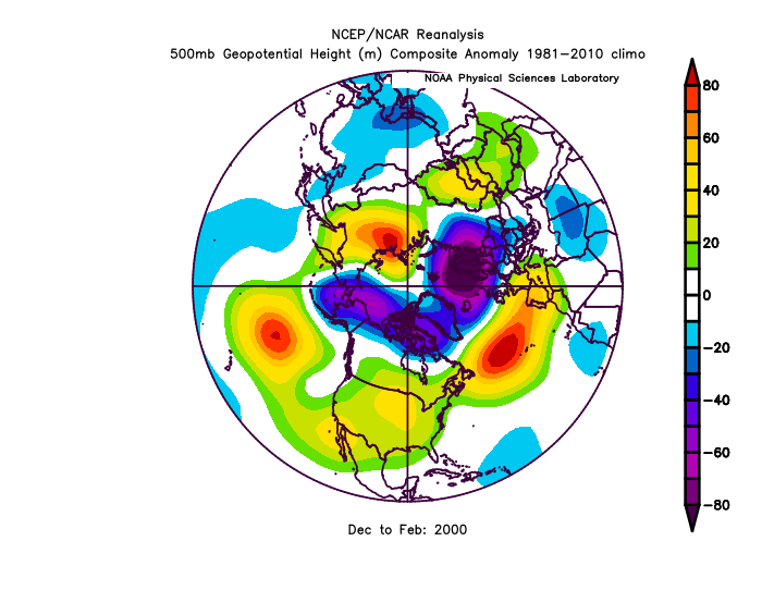
-
December 2021 Medium/Long Range Discussion Thread
psuhoffman replied to North Balti Zen's topic in Mid Atlantic
IMO the key is for the pac ridge to stay poleward. We do need NAO blocking to get much snow in a nina. But if we really want to stack the deck we need the pac ridge to stay north and not become a flat mid latitude one like the last few years. So long as the pac ridge stays encroaching into the EPO domain we don't need the NAO to be some raging beast like last year. In mid winter a -EPO-NAO is a pretty cold pattern here. Whatever the models might show now...that cold in western canada will press southeast under the blocking. If we fail its more likely to be dry than warm imo. We did manage to mostly fail in 2011 with that look...but we were so close so many times to that being a pretty good year. 1979 is an example of a -epo-nao working really well. That was a enso neutral year though. 2013 and 2009 look similar in the means but the atlantic and pacific never worked in tandem. As the atlantic improved the pacific ridge would shift south. If we can get both the pacific ridge to stay poleward AND the nao to go negative at the same time I like our chances. -
December 2021 Medium/Long Range Discussion Thread
psuhoffman replied to North Balti Zen's topic in Mid Atlantic
Where did ya move to @North Balti Zen? -
December 2021 Medium/Long Range Discussion Thread
psuhoffman replied to North Balti Zen's topic in Mid Atlantic
I don't waste a lot of time digging deep into synoptic details of storms past day 5 but one thing I have noticed is that the runs that have a better storm eject the northern stream system further south out west. The runs that eject that feature further north end up without much of a storm at all. It seems the STJ isn't capable of getting it done alone, and this would be typical so believable in a nina. We're probably going to need the NS to phase in and at a far enough south latitude for this to work. As for a "trend" that feature seems to be bouncing all over run to run on the guidance. But the preponderance of evidence is north/no good. But there is a large enough minority clustering of guidance with a further south NS feature not to completely write it off yet. But its more complicated than just "north or south" trend since there are two features here and we actually need a south trend with one of them in order to get a north trend with the other. -
December 2021 Medium/Long Range Discussion Thread
psuhoffman replied to North Balti Zen's topic in Mid Atlantic
It's not actually a linear thing like those charts imply. There are conflicting areas of convection that are both calculated into mapping those charts...as the one near the MC dies out the wave in the Pacific takes over as the dominant factor in mapping those charts and so you suddenly see the wave move towards phase 8. -
December 2021 Medium/Long Range Discussion Thread
psuhoffman replied to North Balti Zen's topic in Mid Atlantic
Last year was really odd. I’ve never seen that good an Atlantic combined with that atrocious a pac. I’ve said before there are two types of Nina’s. Ones with a flat pac ridge and ones with a more poleward ridge. The ones with a flat ridge typically are warm and ugly wrt snow. if you imagine the flow in the map above its straight across the pac and enhanced by gradient between the flat ridge and the vortex to its north in the wpo and epo domains. That’s as ugly a pac as possible. What's odd is those Nina’s typically don’t feature much blocking. That kind of pac isn’t very conducive to a -NAO. Usually that kind of enhances zonal flow in the pac will destructively interfere with attempts at blocking. But we got some of the best blocking of the last decade. A very odd combo. And the blocking did save us from a year like 2008 or 2012. We had way more chances and places not far NW of 95 did ok. That isn’t true in a typical flat pac ridge Niña where it’s common to see little snow until you get well into New England. But that dreadful pac prevented a good winter. This year the pac ridge isn’t flat it’s been poleward and projections continue that base state. Look at the gefs for the end of the month. The north pac is completely reversed from Last year. The ridge poleward alters the flow. Now the flow into the conus is from the arctic not off the pacific. This type of Nina also is more typically linked with blocking. The poleward ridge transports more heat into the high latitudes and disrupts the polar vortex making blocking more likely. If the pac ridge remains poleward AND we get some blocking we should get a colder outcome then last year. Dry and miller Bs are still a way we can fail in that look but lack of cold not as much. This is the setup I expected to get at least some point this winter and why I went with below avg snowfall but not way below and a more decent outcome for a Nina. But luck will have a say. We will get chances but we have to score on some.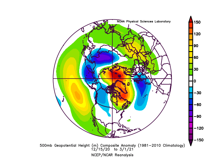
-
December 2021 Medium/Long Range Discussion Thread
psuhoffman replied to North Balti Zen's topic in Mid Atlantic
They can’t be worse than your call. I was wrong about December also…but I don’t go around throwing stones… -
December 2021 Medium/Long Range Discussion Thread
psuhoffman replied to North Balti Zen's topic in Mid Atlantic
2002 is probably the best example of bad luck. Not saying that year should have been good. But we had a good enough pattern for enough time that it shouldn’t have gone down that badly. 1996 is provably the best example of good luck. Yea we had some good patterns (and some bad ones) but almost every threat hit! And honestly some of the looks that created snow weren’t that amazing. Not like 2010 when the pattern really was so good that a repeat of that longwave pattern in a Nino likely would repeat those results or something close. -
December 2021 Medium/Long Range Discussion Thread
psuhoffman replied to North Balti Zen's topic in Mid Atlantic
We should have dismissed that just on the fact there are no comps. The only thing that came remotely close to what models were spitting out in Dec 2017 was PD2 but that wasn’t as long duration, did have a more concentrated system, and was in a Nina. -
December 2021 Medium/Long Range Discussion Thread
psuhoffman replied to North Balti Zen's topic in Mid Atlantic
People forget we wasted this for a month in O1/02 2 storms got suppressed. One phased late. One missed just northwest of us and a good overrunning setup under performed and de amplified as it got to us. But we got about as unlucky as possible from early December to Mid January. Then the bad pattern set in late January and so it was game over. One point specific to those other scenarios 2001/2 that look set in early December and broke around Jan 15. If we repeat the same pattern but start around Xmas I like our odds better. 2018 we also got unlucky with a pretty good longwave pattern for about a month. But we never got much Atlantic help. In a Nina that’s huge. The NAO is even more important in a Nina to slow down the fast NS and force it to dig and amplify under us. It’s really hard to get a significant snow here absent blocking in a Nina. So if the Atlantic cooperates some I’d like our chances more than Dec/Jan 2018 also. But when I say that I just mean our chances to get a decent storm and make this year an ok one. My bar is pretty low. But it will still come down to luck I think some don’t like when I point out “luck” because some like to try to find reason and certainty and some think I’m excusing bad forecasting. But what I’m really doing is admitting we don’t have the skill to discern the meso scale factors that will determine one locations snowfall results at any range. We can try to identify some general longwave characteristics that will increase or decrease our probabilities at longer leads. But then we need the details to break our way and since we don’t yet have the ability to account for those little discreet details we label them “luck” or chaos. I don’t know if we will ever have the ability to accurately account for every little factor at long ranges (I kind of hope not) so for now calling it luck is good enough for me.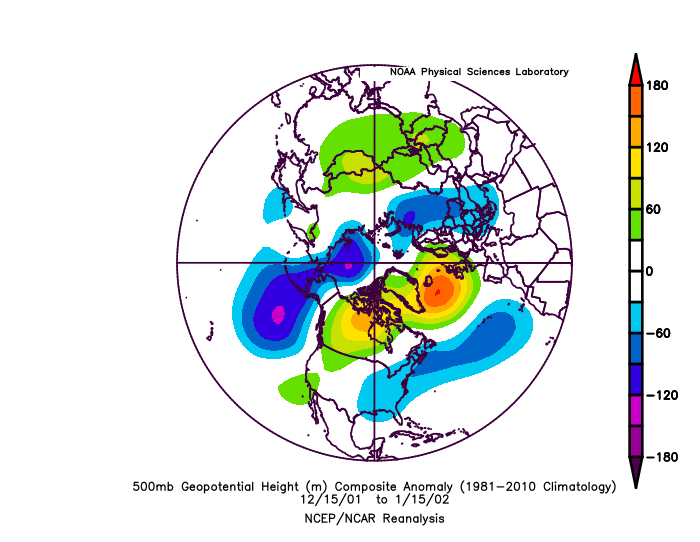
-
December 2021 Medium/Long Range Discussion Thread
psuhoffman replied to North Balti Zen's topic in Mid Atlantic
Nothing wrong with using the probabilities maps as a quick indicator of whether things are improving. But I don’t think we’re close enough for the guidance to “see” far enough into the ”better” pattern for those maps to pick up much yet. I know Xmas looms large and we all want the flip to happen in time and there is some potential to get a wave before Xmas if we time up a high but the much better pattern looks to settle in after Xmas. -
December 2021 Medium/Long Range Discussion Thread
psuhoffman replied to North Balti Zen's topic in Mid Atlantic
We could waste a good pattern. But there is no way to know that when it’s still 10+ Days away from even starting. All we can do now is identify very basic longwave trends. Those are all good. Whether we actually get a snowstorm is to be resolved way way later. I don’t get the people bringing up meso scale stuff as a reason to poop on a long range pattern. -
2021 Mid-Atlantic Severe Weather - General Discussion
psuhoffman replied to Kmlwx's topic in Mid Atlantic
I would get annoyed with his drivel but his life must be so sad and pathetic that we probably should just pity him. -
December 2021 Medium/Long Range Discussion Thread
psuhoffman replied to North Balti Zen's topic in Mid Atlantic
If the NAO ridge continues to retrograde west something will eventually cut underneath into the east and flip the pattern. That epo NAO combo is the kind of pattern that can lead to coast to coast cold. It’s the rare time we ”could” survive a -pna. -
December 2021 Medium/Long Range Discussion Thread
psuhoffman replied to North Balti Zen's topic in Mid Atlantic
We should start getting fantasy unicorn storms soon -
December 2021 Medium/Long Range Discussion Thread
psuhoffman replied to North Balti Zen's topic in Mid Atlantic
The Gefs is much faster moving the mjo into 8. The EPS is getting there but is a week slower and ends still in 7 but moving towards 8. That means the same changed on the EPS likely lie behind the end of its 15 days due to its slower pattern progression. -
December 2021 Medium/Long Range Discussion Thread
psuhoffman replied to North Balti Zen's topic in Mid Atlantic
Yea but you need the arctic cold first lol -
December 2021 Medium/Long Range Discussion Thread
psuhoffman replied to North Balti Zen's topic in Mid Atlantic
Up here when I fail it’s more often from suppression. Things go north of course but usually it’s obvious and not close so it’s not really a “fail”. But the suppression isn’t from cold. Like you said it’s just from the flow or bad timing. And 90% of my snow is rain where you are but even here I’ll take the cold and roll the dice. -
December 2021 Medium/Long Range Discussion Thread
psuhoffman replied to North Balti Zen's topic in Mid Atlantic
PD2 had arctic air around, but mostly just north of us. 1994 arctic air didn’t stop us from getting ice storm after ice storm. And it was absolutely frigid up In central PA that year as they got buried by snow. And it was arctic cold up there in 2014 as I got a ton of snow. The laws of physics don’t change in DC! It just doesn’t get that cold that often to have a chance to snow! no we don’t want some 1050 high over DC but how often does that actually happen? I suppose it’s possible. 1977 happened. But from range I’ll take arctic air and play the odds -
December 2021 Medium/Long Range Discussion Thread
psuhoffman replied to North Balti Zen's topic in Mid Atlantic
THIS x100!!! The lack of snow isn’t because it’s cold. The issue is we often only get really cold at this latitude and this close to the coast in the NW flow behind a wave. Then it warms up in the return flow ahead of the next wave. Cold dry warm wet. But the dry isn’t because it’s cold it’s just a coincidence because we only got cold behind the waves in the flow.


