

psuhoffman
-
Posts
27,419 -
Joined
-
Last visited
Content Type
Profiles
Blogs
Forums
American Weather
Media Demo
Store
Gallery
Everything posted by psuhoffman
-

December 2021 Medium/Long Range Discussion Thread
psuhoffman replied to North Balti Zen's topic in Mid Atlantic
Respectfully disagree. It snowed in 2015 the day after one of our coldest February arctic shots I can remember. And it snows plenty in colder places at 3*. You know why it doesn’t snow often here at 3*? Because it isn’t often that cold here! How often is it 3* when cloudy? (No radiational cooling). Plus any strong storm will press the boundary back north so even if it WAS that cold right before it’s incredibly unlikely to stay that cold here at this latitude during a storm! But we’ve had some nice storms during periods of arctic cold shots. 2 of the last 3 arctic shots produced significant snowstorms. -
December 2021 Medium/Long Range Discussion Thread
psuhoffman replied to North Balti Zen's topic in Mid Atlantic
I’m with CAPE. We can get confluence without arctic air in the pattern. And we can get a storm with it. Actually with the warm waters I’d take my chances in a suppressive pattern WITH arctic air to enhance baroclinicity. The last 2 weeks of January last winter is what suppression without cold looks like. The last several true arctic shots we got did lead to snow. -
December 2021 Medium/Long Range Discussion Thread
psuhoffman replied to North Balti Zen's topic in Mid Atlantic
I'm sure I will take some heat for this...since 1996 seems to hold some spot of reverence and honor with snow weenies, but I have come to believe 1996 was a combination of a good pattern (for a nina) but more than that just a LOT of good luck. If you go through the H5 patterns that year...it wasn't as much a classic can't miss pattern as 2010 was for example. It was good at times, don't get me wrong...but no better than the h5 look we have had in other nina winters that had periods of blocking. There were also hints of some of the tendancies in a few other storms that hurt us in other Nina's but somehow didnt'. There were several late developing miller b and frontal wave storms that year...but somehow they managed to not screw 95 while also hitting the coastal plan and immediate coast also. I have come to think maybe we just got lucky with that January blizzard hitting...and a couple other storms. Maybe that was just the slot machine coming up triple bars. If you take all other -NAO nina patterns...its not like we don't get snow and can't get storms. Just that year managed a much higher hit rate than you would expect. Instead of agonizing over some intricate reason why maybe it was just luck. -
December 2021 Medium/Long Range Discussion Thread
psuhoffman replied to North Balti Zen's topic in Mid Atlantic
Nothing is guaranteed and its possible the MJO fails us again. But wrt to the example you gave, and I remember it well, it started as a standing wave in the IO around phase 3. Phase 3 isnt ideal but its not bad and we were stuck in kinda a mediocre pattern and people were wanting the standing wave to break so the MJO could progress and I remember saying "be careful what you wish for" because by far the strongest profile for the MJO at that time was for it to go ape in phases 4-6 if the IO wave died. Thats exactly what happened. It's one of the things that contributed to my "were pretty much screwed" post I made around the holidays that year that got some people upset. A wave starting in phase 6 is much more likely to progress into 8 than a wave starting in 3. The great MJO fake out of 2019 also started in phases 3/4 not phase 6. There are some differences. My other problem with that kind of skepticism is that its not based in predictive science just pure skepticism. Its useless in making a real forecast. It's like the people that say "its just gonna suck because it sucks right now". That's really bad science. Persistence isn't really a thing, its confirmation bias. It feels like "suck" is persistent around here because our climo is "suck" most of the time wrt snow. NOT snowing is the normal in our area. Snow is the anomaly. So simply saying "its gonna suck" all the time makes you look really smart most of the time but you aren't actually making a science based prediction. Just playing the odds. Look at our recent history even. 2015 we had almost no snow into February. The "persistence" matra was LOUD. Then we went on an epic run. 2016 was as god awful a start as you could possibly have into mid January...then one of our biggest snowstorms in history hit. 2018 we had almost no snow at all then got several snows and a 4-8" storm in March. 2019 started cold, got really warm, turned cold/snowy for a couple weeks...then turned warm again. Persistence isnt really a thing...its just we will skew towards a bad pattern for snow more often then not because that's whats "normal" here. Another thing, there are legit science based reasons to be skeptical. The SST profile in the tropical pac bothers me. Its definitely more favorable for convection in the warm MJO phases and destructive to a wave amplifying in 8/1. The nina base state would also support the MJO being less helpful. But the people poo pooing the MJO aren't really making the science arguments they are mostly just making the "things suck so they will continue to suck and we should just expect suck" type arguments and I hate that crap. Its just lazy forecasting. Lastly, when I am "interested" in something it doesn't necessarily mean I expect snow. I know our climo. I know snow is an anomaly. So I come at this from "looking for possibilities" POV. How COULD we get snow. I know most of these possibilities will fail. But waiting until its about to snow to get excited would be boring most of the time since we spend the majority of our time in bad patterns. The final point I will make is, at some point this winter it is VERY likely we will get a better pattern for at least some time. Even the absolute worst winters had SOME opportunities. Even the years we had a total fail there were SOME (granted not many) chances but it was a combo of bad luck and failing at the few chances we did get and having a bad pattern MOST of the time. I can't remember a year where it was wall to wall start to finish a totally hopeless pattern. So the odds say at some point the pattern will evolve to something better than the absolute no hope god awful look we are heading into. I am focused on looking for hints of how that may happen. -
I saw a couple flakes… so I picked up some selsun blue.
-
December 2021 Medium/Long Range Discussion Thread
psuhoffman replied to North Balti Zen's topic in Mid Atlantic
This wave originating in 6 is more favorable than some recent years when we saw waves originate in 3 then slowly cycle through the MC. Additionally while 6 isn’t favorable there is evidence phase 6/7 is favorable to disrupting the PV. Makes me wonder if the colder looks from 8/1 partially are tied to the after effects of 6/7 since we know PV disruption has a significant lag effect on sensible weather. I’m not an mjo expert but from experience my guess is the wave makes it at least to 8. I’ve seen the same theories and it jives with my anecdotal experiences. Slower waves seem to have greater impact on the conus pattern in my experience. Not to mention a slower wave moving through 8/1 simply gives us more time. Lastly I like a wave starting in 6 much better than the last few years when it seemed everything wanted to start in 2/3 then slowly traverse the warm hell phases then die right as they got to 8. No guarantees but this scenario has a much higher chance of working in our favor Imo. -
December 2021 Medium/Long Range Discussion Thread
psuhoffman replied to North Balti Zen's topic in Mid Atlantic
It’s frustrating now but the very slow speed of the mjo wave will be a good thing in a few weeks. -
Just wanted to apologize for not doing much with this lately or trying to set one up to discuss the impending flizzard…but my 3 year old has the flu and is not doing well.
-
So we will have hourly model runs soon. That’s gonna be great for the manic tendencies here.
-
December 2021 Medium/Long Range Discussion Thread
psuhoffman replied to North Balti Zen's topic in Mid Atlantic
Relax I’m giving him a hard time. But he would do better to know his climo. CAPE does! He knows snow is an anomaly where he is and doesn’t act like he expects it. I had to spend significant portions of some winters in Cape May many years ago and when I was there I didn’t even bother to track. It never once snowed over the probably ~100 days cumulative I spend there in peak winter but I wasn’t upset at all because I didn’t expect anything and hadn’t bothered wasting my time tracking on the rare chance it snowed. Same when I was dating a girl in NC and spent significant time there or visiting my parents in winter when they were living down there. If you live somewhere that averages like 10-15” of snow, and most of that comes because once every 10 years or so you get some crazy anomalous snowy year…getting frustrated when it doesn’t snow is just setting yourself up to hate life. -
December 2021 Medium/Long Range Discussion Thread
psuhoffman replied to North Balti Zen's topic in Mid Atlantic
One reason I originally expected a colder December. But some of the Nina’s that started this way turned colder mid winter so it’s not necessarily all bad. -
December 2021 Medium/Long Range Discussion Thread
psuhoffman replied to North Balti Zen's topic in Mid Atlantic
https://psl.noaa.gov/cgi-bin/data/composites/printpage.pl and if you really want to go down the rabbit hole you can make ones with specific dates here. That’s how I created the snowstorm composites in the snow climo thread. https://psl.noaa.gov/data/composites/day/ -
December 2021 Medium/Long Range Discussion Thread
psuhoffman replied to North Balti Zen's topic in Mid Atlantic
Why you still here? You should be contacting realtors. -
December 2021 Medium/Long Range Discussion Thread
psuhoffman replied to North Balti Zen's topic in Mid Atlantic
That’s a perception that probably comes from the fact that even when we get a colder nina they still tend not to be great in terms of snow and the warmed ones can be just awful. this is all Nina’s in the past 30 years Dec-Feb If anything the trough is in the east more than the west. The obvious dominant effect is that central pac ridge. There are really 2 pattern types to Nina. When that ridge is flat all of the conus tends to torch and get flooded with pac puke. When that ridge extends poleward we tend to see cold extend from western Canada into the northeast. Problem is even in the colder look there is no STJ so we get a cold dry pattern usually. That’s still preferable and we can, with blocking, score some snow but absent 1996 we don’t get enough for a “big” winter even in a cold nina.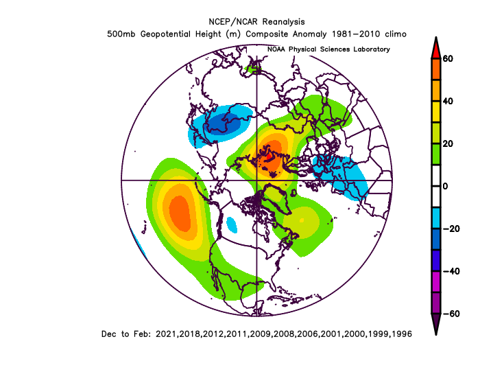
-
December 2021 Medium/Long Range Discussion Thread
psuhoffman replied to North Balti Zen's topic in Mid Atlantic
Comparing this season so far to similar cold ensos I do think that’s where we go at some point. But we mostly wasted similar good looks in some of those similar comps Ive been looking at so not sure how to feel. It’s too early to say what the base state is It’s possible what they mean are observed issues the guidance is having with initializing that feature accurately and not the tired waiting to come ashore thing. If you cared that much you wouldn’t live there -
December 2021 Medium/Long Range Discussion Thread
psuhoffman replied to North Balti Zen's topic in Mid Atlantic
I remember a few years ago someone was arguing why a cold phase mjo wasn’t actually going to be cold using a bunch of really specific variables. I remember I got annoyed because I asked “well when those 18 things are all true what mjo phase do we want if 8 is no good and got no answer”. Maybe this will be another example of how the mjo works except when it doesn’t. -
December 2021 Medium/Long Range Discussion Thread
psuhoffman replied to North Balti Zen's topic in Mid Atlantic
I heard ukmet was decent 1-3” -
December 2021 Medium/Long Range Discussion Thread
psuhoffman replied to North Balti Zen's topic in Mid Atlantic
Across all guidance the trend is a better cold push but also a weaker system. That also means colder but in a Nina sheared apart is always a threat. This was always a thread the needle. Still is. -
December 2021 Medium/Long Range Discussion Thread
psuhoffman replied to North Balti Zen's topic in Mid Atlantic
Icon is a little snow mostly southeast of DC but it’s largely a strung out weak non event. -
December 2021 Medium/Long Range Discussion Thread
psuhoffman replied to North Balti Zen's topic in Mid Atlantic
It’s far enough to tell what would happen. It would be weak and very likely nothing of consequence. The SW is not amplified enough on the NAM. -
December 2021 Medium/Long Range Discussion Thread
psuhoffman replied to North Balti Zen's topic in Mid Atlantic
Always -
December 2021 Medium/Long Range Discussion Thread
psuhoffman replied to North Balti Zen's topic in Mid Atlantic
It would be incredibly rare to have a longwave pattern set in this early and dominate the whole winter. Not impossible but that’s not usually how we get a total dreg winter. The more common way (like 2002 and 2020) is when we waste a decent pattern in December into early January then a dreg pattern sets in early January that knocks out our best climo period. It’s not impossible to see this last 3 months but that isn’t typical even in our bad winters. But getting a better pattern doesn’t guarantee us anything either. In a Nina we tend to waste some good patterns also. But this is one reason I favor a not so good but not necessarily a really awful winter. -
December 2021 Medium/Long Range Discussion Thread
psuhoffman replied to North Balti Zen's topic in Mid Atlantic
I’m quite pleased with the timing of the way everything is progressing. Getting our best pattern mid winter is always preferable. And I do fully expect the longwave pattern to evolve to a decent if not good one eventually. But a couple of the best nina analogs to right now, while the h5 pattern did improve significantly it was mostly wasted. I guess that’s somewhat expected in a Nina. When it’s cold it’s dry. So it’s likely still going to be a slog but I’ll take my chances getting our best looks between Xmas and March v now. -
December 2021 Medium/Long Range Discussion Thread
psuhoffman replied to North Balti Zen's topic in Mid Atlantic
This was funny the first 10 times but you need to diversify your act. -
December 2021 Medium/Long Range Discussion Thread
psuhoffman replied to North Balti Zen's topic in Mid Atlantic
I’d like to see some evidence the nearly constant pacific onslaught of the last several years was only a temporary cyclical thing because I can certainly think of some reasons it could be a product of changes related to “you know what” like the enhanced tightened gradient in the north pac due to the expanding Hadley cell. That, imo, has been problem numero uno in getting any real sustained cold here. Seeing signs that isn’t permanent would be welcome.


