psuhoffman
-
Posts
26,411 -
Joined
-
Last visited
Content Type
Profiles
Blogs
Forums
American Weather
Media Demo
Store
Gallery
Everything posted by psuhoffman
-
Given our regions reliance on the NAO I think this would get a collective hallelujah
-
There were a lot in the 2000s. A couple in 2002/3. One in Jan 2004 gave MD 2-4”. There were several 1-3” clippers in 2004/5. A couple in Jan/feb 2007 and a big one Dec 2007, the only good snow that year. Then I remember a couple in 2009. This decade has been less common. There have been a few but we spent a lot of the decade in either a blocking pattern likely to squash clippers or a warm pattern where they would be way north of us.
-

Mid January/Mid February Medium/Long Range Discussion
psuhoffman replied to WinterWxLuvr's topic in Mid Atlantic
That would just hurt more...a bombing coastal deforming the hell out of us and its 38 degrees and heavy rain...probably mixed with slush bombs at times just to make us want to kill cute fluffy animals -
My elevation combined with being "just far enough north" have prevented my snowfall climo from being impacted much. Actually the last 10 years have increased my "avg" here some. As of right now I am still just cold enough to eek my way to a decent total in bad years "usually" and hit really big in the big years. What it has done is increase the difference between here and places like Baltimore. If the warming continues it will eventually impact up here also.
-
Mid January/Mid February Medium/Long Range Discussion
psuhoffman replied to WinterWxLuvr's topic in Mid Atlantic
The EPS is already kicking the can again...compared to the weeklies from Monday. This was the weeklies run for what is now day 15 on last nights EPS...it was leading to that better pattern mid February there by already obviously moving the NAM state towards neutral and a developing EPO ridge... but as usual as we get a day closer look what is happening...the NAM state is still strongly positive now for the same time and the EPO ridge is being shunted south of the EPO domain by the strong Vortex. This has happened again and again. -
It was agonizing up here...I did have a clipper put down about 2.5" at the start of the pattern...but it was dry and the next day we got high winds that blew all the snow into the woods. Then we got nothing but incredibly minor snowfalls the rest of the pattern...so I spend a long period with frigid cold...uncomfortable to go out cold...high heating bill, and no snow on my lawn to show for it. One of the more frustrating periods in the last decade to me.
-
For most areas...no, but for areas that are typically right on the southern edge of where it's cold enough to snow often...yes. That 1C is about 2F plus the effect is not uniform in all locations. There has been an even greater warming due to urban heat island effects in urban areas. So go back and look at all the historical snowfalls before 1990 where the temperature at DCA was around 33-34 degrees and kiss those goodbye. Then look at all the snowfalls where the temperature was 30-32 degrees and cut those totals way down because now it would be 33-34 and really super wet low ratio snowfalls. On top of that sometimes the effect of a couple degree warming can be more drastic right along the thermal boundary because there is a critical mass where a storm will take a further north track where if you sample the entire continent the temperatures are only 1-2 degrees warmer than a similar pattern 50 years ago...but the track of the storm is 100 miles further north and so in our specific area the rain snow line shifted more than you would think just from a 1-2 degree change. So in short... places where it was very cold in winter in some cases have become more snowy. For warm places and cold places it wont matter that much. But for places like DC that were often right on the razors edge for snowfall...yes it matters a lot.
-
Thanks... that was the stretch I was remembering though, just thought it went to mid month..probably felt longer than it was because it was torture being so freaking cold with no appreciable snow.
-
you should go read the "would these storms even work today" thread. Some good discussion about how our climo is changing. Especially the discussion yesterday between myself, Isotherm, and Frd. Basically... our winter's are becoming more extreme in both directions. We are tending to "hit it big" more often when we do get a conducive pattern...but spending more time in bad patterns. To get cold we almost need an extremely anomalous EPO or NAO pattern anymore. Anything else and we end up warm. It's a lot harder for us to luck our way into decent snowfall in a "meh" pattern anymore. We spend long periods in awful no hope patterns...then hit it really big in years where we get either a dominant EPO or NAO ridge. The result is that while our "avg" isnt changing much...how we get that avg is. We end up with more really bad years... but also more really good years. For some places far enough north to end up on the right side of the thermal boundary the tendency for more juiced up systems due to the increased baroclinicity from warming in winter is actually increasing their snowfall avg. But we are right along the edge of where it typically can get cold enough to snow...so for us its not as helpful as we are getting more big snowstorms...but spending more years in total crap patterns and getting almost no snow. Since there is likely a limit to how big storms can really get...if the warming continues and we spend more and more time in bad patterns and are able to luck our way to less and less snow in "not ideal" patterns...out avg will likely continue to drop. But I guess my point is...that is the normal now. It's been happening for long enough now and makes sense given the changing climate regime that its not likely a fluke that is going to just turn around. So any short period that doesn't include one of our "big years" is likely to be "the worst stretch ever" because 30/50/100 years ago DC had a colder climate and was able to luck its way to a few small to medium snowfalls in a not perfect pattern. That is becoming harder and harder to do...so we either with a ton of snow in a perfect pattern...or very very little in everything else. That is the new normal.
-
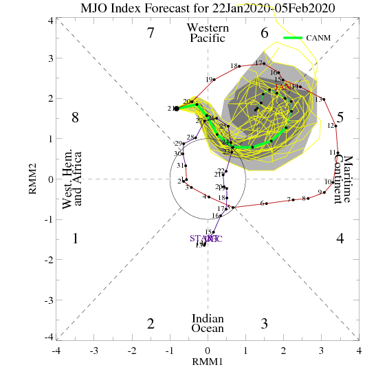
my fault..I set that one up posting that MJO plot clearly telling our winter to bleep off... and asking people to caption it... That was kind of exactly what I was thinking too
-
If an mjo plot could talk....caption this
-
He exaggerated the cold but his point is true. In 2017/18 we had a period from Dec 26-Jan 15 well below normal temps and away from the immediate coast it did very few any good wrt snow. It’s was a very dry period. I was below freezing that entire 3 week stretch and had like 4” from 3 minor events to show for it. And that isn’t the only such period. We have had other extended cold dry stretches. Since we aren’t a cold location that’s not common but it’s not a crazy anomaly. And we have had a lot of warm wet patterns that didn’t produce any snow. Truth is we need cold AND precip to get snow. They are equally important. From a long distance yes cold seems a better play because cold dry is numerically less likely than warm. But once a pattern is staring us in the face and it’s obvious it’s a dry suppressed one the whole “at least it’s cold” thing doesn’t bring me any comfort. Now some like cold. That’s totally ok. But if you like snow and don’t care about the thermometer than there are certain pattern markers we need within a cold look to get snow.
-
Mid January/Mid February Medium/Long Range Discussion
psuhoffman replied to WinterWxLuvr's topic in Mid Atlantic
That “better” look is so tenuous. Guidance relaxes the AK vortex some and builds just enough ridge barely near the NAO domain and in the Southwest to squeeze a cold shot down the middle between the two ridges. But all of the changes are barely enough and if any of them is wrong it’s just more of the same. I don’t feel good until I see either the AO/NAO really start to flip or that Vortex away from AK. -
January 2020 General Discussions & Observations Thread
psuhoffman replied to Rtd208's topic in New York City Metro
We have this debate in the mid Atlantic sub too. First of all normal and avg aren’t the same. If you look at what a standard deviation for snowfall is it will likely give you a wide range. But the issue is to get that avg you need above and below avg years. If all you ever got was above avg then avg years your avg would perpetually rise. So if you recently had a string of mostly above avg winters it is normal to have a string of below avg ones to balance it out. -
I can see both sides. @RevWarReenactor, @losetoa6 lives near me. Our climo up here can be good for snow and even keeping snowcover into late March. I’ve even seen decent snow in April but by then keeping in on the ground long is a lost cause. But I had almost a week of snowcover the last week of March 2018. Also a week of snow Otg in Mar 2017 and 2015. On the other hand if I were where you are I likely wouldn’t really see March as a winter month either. And without that one nice wintery few days up here earlier this month I probably would be a lot less content right now so I get where you are at.
-
Mid January/Mid February Medium/Long Range Discussion
psuhoffman replied to WinterWxLuvr's topic in Mid Atlantic
Analysis doesn’t make it snow. Maybe some of us enjoy analyzing the pattern no matter the outcome. -
Maybe it looks close for our area but honestly I’m not invested enough to dig that deep.
-
Mid January/Mid February Medium/Long Range Discussion
psuhoffman replied to WinterWxLuvr's topic in Mid Atlantic
Couldn’t that be true of everyone? It probably would be more effective to pool global resources into one system and crate the best single combination. Yes there might need to be more than one model (or a beefed up ensemble system) but having tons of inferior models floating around just adds noise imo. But getting that kind of coordination and cooperation is difficult in anything. -
euro ensembles... thing is...the 1-3" of snow it has in our NW regions is not from a lot of small hits...its from a couple massive ones but with the vast majority showing nothing. So basically there is a very slim chance that if everything went exactly right...they do that by having a perfect H5 track and then bombing a slow moving coastal and deforming the hell out of us...how often does that actually happen here? then maybe we get a big storm...but the high probability is just a rainstorm pretty much everywhere except the highest elevations or north of our region.
-
I’m gonna ignore all other evidence and assume numbers 4/5 know what’s up

-
Mid January/Mid February Medium/Long Range Discussion
psuhoffman replied to WinterWxLuvr's topic in Mid Atlantic
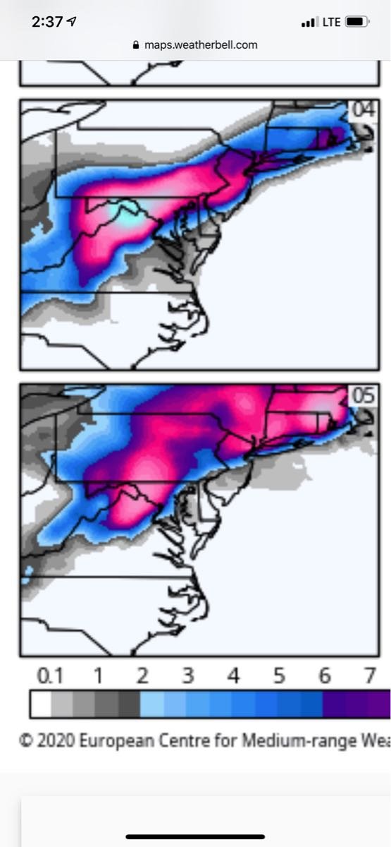
It might encroach the southern edge of the NAO domain some...but its not the kind of look that will influence the pattern the way we need. A better sign is the guidance ejecting the AK vortex...although todays GEFS seems to take a "step back" on that. I don't care about the blue over us if there is still a AK and Greenland Vortex combo...it will not be cold enough in all likelihood regardless of a day 15 look. This is a composite of warning level snowfalls at BWI with a somewhat similar Pac look to this year. Notice where we need the ridging in the NAO region to be.
-
Mid January/Mid February Medium/Long Range Discussion
psuhoffman replied to WinterWxLuvr's topic in Mid Atlantic
The ridging I see is mostly south of the NAO domain. -
Mid January/Mid February Medium/Long Range Discussion
psuhoffman replied to WinterWxLuvr's topic in Mid Atlantic
But it’s close day 10 to a flood -
Mid January/Mid February Medium/Long Range Discussion
psuhoffman replied to WinterWxLuvr's topic in Mid Atlantic
What is messing this up in the broader sense is the longwave pattern. The upper low is stuck under blocking in canada yes... and that forces a south track of that feature (considering where it starts out) and that is why a ridge near Hudson Bay can sometimes work for us with a crappy background state... but in this case the wall to wall lower heights all across from AK to the NAO is blasting warm air across the continent. The problem isnt really the upper low. I guess it is if you were hoping to salvage any frozen in spite of the fact the antecendent airmass is a rotting POS. Then yea...the only way was to get a damn perfect H5 track and a bombing surface low to our east. But that is so rare. The real problem is the surface low is going to try to seek out the baroclinic zone and that is way way way north. So even with a pretty ok upper track the surface low is going to cut, on some runs it even ends up NW of the upper low for a time. That is why we see those wacky outcomes. If there was any cold at all this would be a big snowstorm because the surface low would stay to the southeast of the upper low along the boundary. We are left praying for some 1/100 perfect upper low to track under us and have an amplified enough system to create its own cold air...how often does that work. More for you than DC I guess...but its the larger picture that is the real problem imo not the micro level issues with the H5 track.