psuhoffman
-
Posts
27,419 -
Joined
-
Last visited
Content Type
Profiles
Blogs
Forums
American Weather
Media Demo
Store
Gallery
Everything posted by psuhoffman
-
Naw at the end it’s heading the same way the eps and weeklies are. And that’s not bad. But it sucks we might have to wait. Sucks more if it’s wrong and the op gfs is how this goes...
-
The only saving grace there would be hints the NAM state is flipping. Build the heights more over the top into GL and displace the trough out of the high latitudes and it could get better. But by then it’s mid Feb. let’s just hope that run smoked some funky stuff.
-
I mostly missed that Jan storm. My 2 biggest snows were the November snow and the March one. But your point is legit. I liked 2018 better though. The 6” in mid December was nice and kind of a surprise. There was a super cold clipper storm in January. One half decent snow in February and then I ended the year with a bang in March. 3 accumulating snows and one of them 14” that stayed otg a week even late March . I ended that winter feeling really satisfied. I had almost identical totals both years but last year felt “empty” for some reason.
-
It’s an op at super long range but the gfs is the biggest disaster I’ve ever seen at day 15. Just over 24 hours ago was that epic double hit snow run. This one has no more chance of being right. Let’s hope
-
“Whiff again?” What exactly are you chasing? March 2018 produced a warning level snowfall. Last year was a near normal snow year with several snowfalls. So what is the “again”? Or do you mean you are chasing the rare winter like 1996/2003/2010/2014 when it snows easy and often. If so yea this probably ain’t it. But is there a good chance it will snow again some this year...yea. Some of us are chasing that.
-
March 2018.
-
Cfs says mid Feb is worth waiting for I mean it has to be right eventually
-
No it was a nice run imo. Would give us opportunities for snow in February for sure.
-
Very nice weeklies run fwiw
-
I don’t put a lot of faith in anything past day 10. The EPS isn’t great but it’s a small adjustment from either good or bad. There will be adjustments. We will see.
-
How’s the fog?
-
It is. So that says our chances for snow are about normal, which for us isn’t very good. Lol however hidden within that are 2 facts...most of that comes day 12-15 from a specific threat. So that specific time period has some promise. And the pattern is mediocre but a slight adjustment from good. It’s not the same as a bad mean in a pattern with a ton of major flaws. That said it was a disappointing last 24 hours with the EPS. It hasn’t radically shifted any features but imperfections within the pattern have shown up to limit the probabilities.
-
That's not true...but it was a pretty bad run. It really goes crazy with the ridge in the northeast day 7-11 and its lights out on any chance there.... then there are a scattering of hits in the day 12-15 range but nothing to the level of the GEFS and GEPS. The pattern looks close enough to workable that it's not out of the question something changes and we sneak a threat in but the last couple EPS runs have not been friendly.
-
GEPS and GEFS both like the idea of a snowstorm somewhere in the mid Atlantic day 10-15
-
the op euro is a total dumpster fire disaster, but its just one op run at long range so.... But it does EVERYTHING the opposite of how we want... doesn't phase the ocean storm next week and slides out out, then washes out the day 9 threat completely so it doesn't amplify...crashes energy into the west and sets up a full latitude western trough eastern ridge...and leaves us in a total dumpster fire day 10. LOL
-
How much snow did you get last week?
-
The overall look day 10-15 is about as good as we can ask for on the GEFS There is definitely high pressure heading into the day 10 threat...we just need slightly lower heights near 50/50 to hold it in... After that...this is an excellent looking pressure profile...temps...and precip for an east coast snowstorm...


-
I would not totally give up on the day 10 threat until its into the medium range. There is an obvious issue...the cold is very stale by then and with the amount of ridging in Quebec...if there isn't enough of a 50/50 to keep confluence and resist the southerly flow ahead of the trough we will torch. But...there are vorts flying around and some do end up in a spot that could help...but the majority of the guidance says they either don't amplify enough or are not in the right spot at the right time. One way to really increase the chances is if the ocean storm next week phases with the NS and gets pulled up into the 50/50 location. That would change the equation and guidance would flip to a colder solution right quick. But its not a high probability ATT. After that all the guidance opens a legit window as whatever happens better or worse with day 10 they all agree that wave WILL amplify and knock down the ridging to our northeast and create a favorable window behind it with a pretty good looking trough axis and ridging across central Canada. It's the best look we have had yet for a legit snowstorm. Of course that isn't saying much...its a pretty low bar.
-
The overall pattern looks ok. The day 10 upper level energy actually gets forced under us despite being in the upper midwest cut off... that shows the effect of the blocking regime in Canada...problem is it scours out all the cold first...the Ocean Storm doesn't phase this time and so it slides out too far south to impact the flow and thus the southerly flow ahead of the trough torches our temps. The storm is forced under the blocking but it doesn't matter. Details in the longwave pattern matter. After that is when we have a real shot according to all guidance. IF the long range guidance is close to right there is a legit good window day 12-15 and the GFS almost is a hit but the system is disjointed and fails to come together...too much NS interference and a sloppy phase. That would be a supreme example of "bad luck" in an actual very good pattern.
-
@frd BAMWX is focusing on energy, and that is almost entirely temperature dependent...and given the recent bias and the look of ridging across canada cutting off cross polar flow...I would lean normal to slightly above overall also. But we are mostly hunting snow which is much different. We don't need an arctic dump in mid winter to get a snowstorm.
-
about 20% of the time we get lucky and some anomalous feature dominates the winter pattern in a way that makes it favorable for snow here. Sometimes its the NAO (1996/2010). Sometimes its the EPO (2003, 2014). It is becoming obvious this is NOT one of those years. The rest of the time the pattern is flawed and we will scrape and claw to get any snow and if we are lucky a couple times the winter is at least decent with a couple snow events...or if we fail to get lucky they can end up total dumpster fire years like 2002. Keep in mind even 2002 had a great period of NAO blocking and a few threats that just didnt work out, one got suppressed, one was slightly too warm in the boundary layer in the coastal plain, one just didnt come together and ended up the only small snow event of the year. With some luck we get a couple of those to hit and we remember 2002 like a lot of other typical mediocre winters. On the other hand 2000 had one good period over 10 days where 2-3 storms hit depending on where you were...but only one was really big in 95. What if that one storm did get suppressed like the guidance thought? We would remember that like we do 2002. If this is not going to be 1996/2003/2010/2014...and its probably NOT, then we are going to have to deal with flawed patterns and hope we get lucky a couple times to eek out a mediocre year with some snow. That is just how it is. And that is how it is most of the time.
-
After looking over the 3 ensembles overnight... After the day 9/10 threat (that has been covered already) the EPS and GEPS both agree on developing a fairly favorable pattern. The GEFS is further east with the eastern trough but that could be its bias to press cold too much. We actually want the trough centered further back. We have been in this cycle of 10-15 day patterns with short transitional periods in between since November. That looks to continue. The next pattern is starting to show itself as one dominated by a central North American Ridge with the southern Jet undercutting across the US. That can work if we can time up a system with a 50/50 low. It's actually a pretty common look within snow analogs. It's not a very cold look but get a storm to track right under the blocking ridge and it can work. But like @C.A.P.E. said right now there are discreet warts showing that prevent that on guidance. Too much ridging extending to our northeast being the main one. I really debated even saying this because I do not want to send this thread off on a tangent... but it's something that I have been kicking around in my head. There were a LOT of snowstorms in the data set with a look close to what we have coming up. But they were mostly pretty warm storms...a LOT of storms where we managed to overcome marginal temperatures. It is not a cold pattern look. But...looking at some of those storms from the 50's, 60's, 70's, even 80's and 90s....I have to wonder if the atmospheric base state is cold enough right now for that to work. Without starting a debate about climate change, the fact is the base state is warmer right now...I am not getting into the why or what to do about it debate, there is another thread for that so save it. And you know who I am talking too. But would a storm from the 1970s that dropped 8" of heavy wet snow from 1.3 qpf on a day with a high of 35 and a low of 31 even work right now? And that is kind of the profile of a LOT of the storms in the "Hudson Bay +AO" snow set. Just a thought... As for where we go AFTER this...there are signs again of the pattern starting to shift towards day 15. Where is unclear though. There are signs of a trough in the north PAC...where exactly that ends up might be the key. If that sets up near the Aleutians we might shift into the typical EPO ridge pattern we kind of expected to be setting up this week. If that presses too far east into North America...we probably get flooded with pac puke unless the NAO flips and there is no sign of that. Of course phase changes up top tend to happen within 10 days so we probably won't know when its 15 days away. The MJO is sending conflicting signals in the long range but most of all it seems to be going somewhat dormant after this current wave fades. But I see no sign of a return to a strong MC signal so that is a positive. We still have agreement on the long range guidance of an EPO ridge +NAO pattern...but they were advertising that the next 2 weeks and totally missed so how reliable are they at 3-4 weeks? The only consistent theme this year is variability and a lot of conflicting signals. So I guess I am saying I have no freaking clue what happens after this coming 10-14 day pattern. I wouldn't be shocked if we end up with a favorable look...or end up in another no hope dumpster fire one.
-
Our fate isnt as dire as some of those snow means indicate. The guidance across the board did deteriorate wrt the day 10 threat but that is dependent on a single feature...getting a stronger 50/50 to knock down ridging to our northeast... that it could easily trend back on guidance if that one thing changes. Actually across guidance there was a trend towards squashing that wave because of "too much ridging" up top. But either way that isnt a high probability right now...but its not completely dead either. After that the snow means look pretty ho hum but part of that is due to a scatter shot in the day 11-15. There are a lot of misses to our south on the GEPS/EPS/GEFS. Some misses to the north (but not by much) and a few hits. That scattershot produces a mean that is unimpressive...but is not the same as a similarly unimpressive mean from a consensus that everything will go north of us. That is a bigger problem and much less likely to change in our favor. As the pattern day 11-15 gets closer the guidance will converge on where the waves within that period will track and once they do we will see somewhere benefit. It could end up NC. It could end up here...it could end up just north of us...but somewhere within that box will likely get snow in that period.
-
@Ralph Wiggum If we break down all the different combinations of patterns...the problem is only like 20% of them are "good for snow" here...and even in one of those "good for snow" patterns we need luck or we can waste it. The pattern we are going into isnt a "good for snow" pattern...but its not in the "bad for snow" either. It's kinda a "meh" look... and we sometimes score in those but it will take some things breaking our way. If your point is that our odds of a big snow within the next 10 days continues to be low... you are right. But that would be an accurate statement 95% of the time. But if you are implying the pattern is not really changing and everything remains the same...that is not accurate. Different doesn't necessarily mean snow though.
-
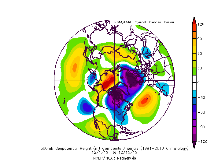
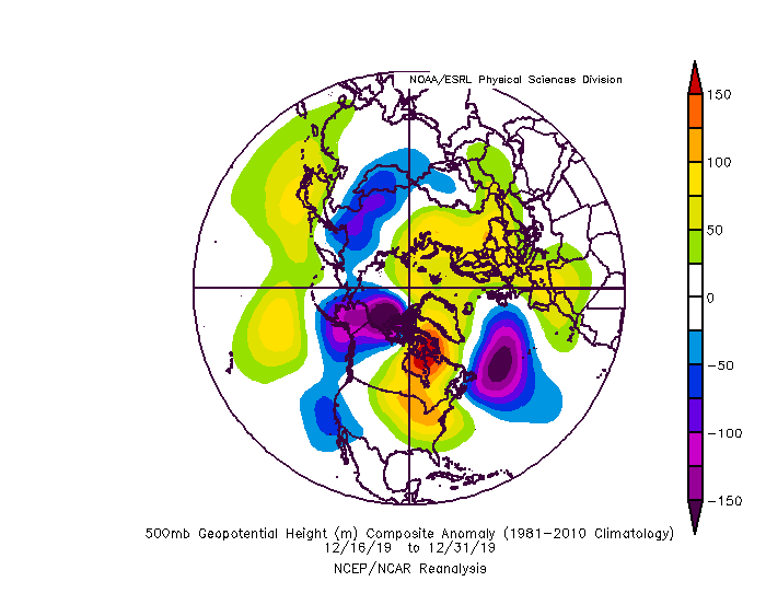
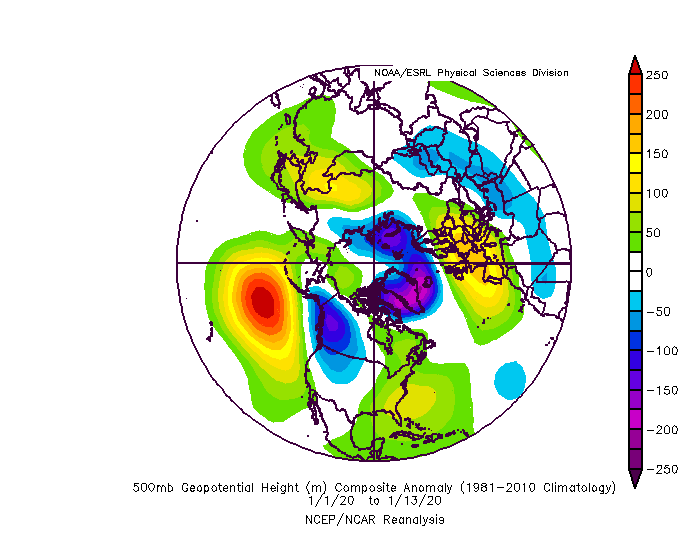
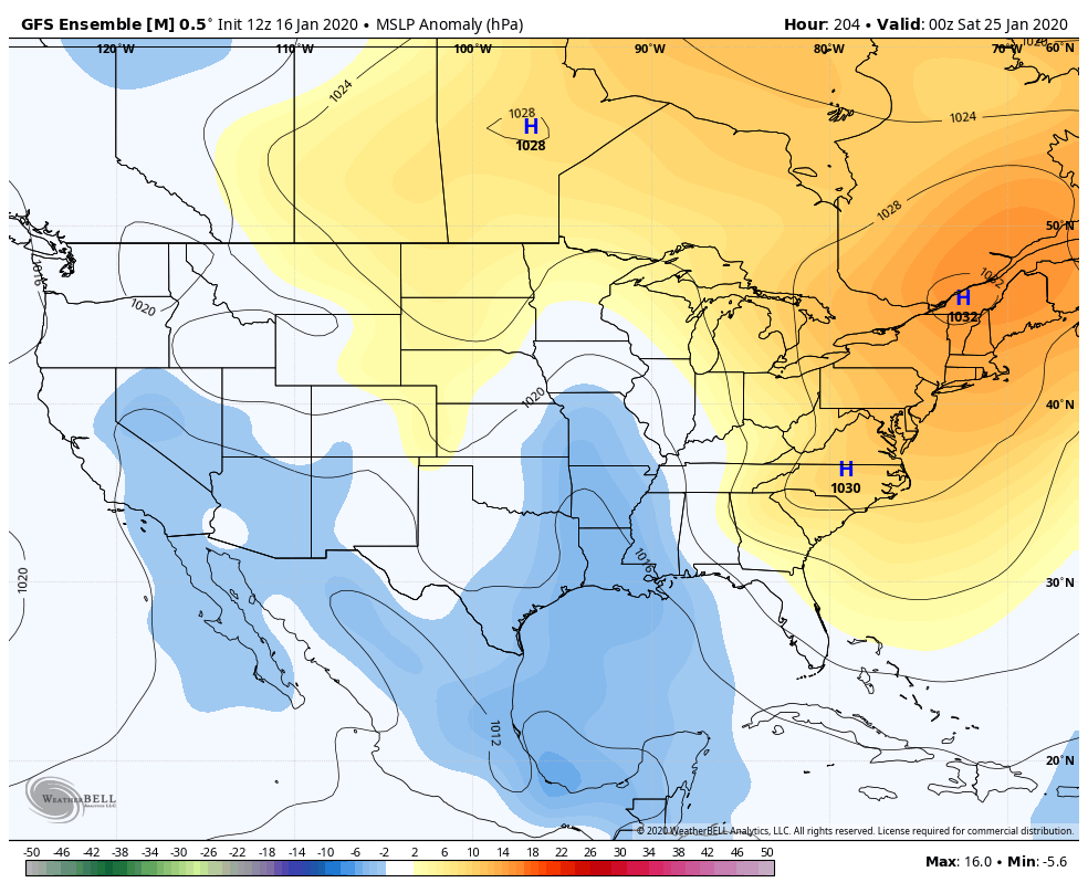
You clearly are implying some kind of continuity with the seasonal pattern this year...but in reality we have had none. The only constant has been consistent change. So far this winter season we have had 3 very distinct DIFFERENT 2 week patterns. And we are heading into another 4th different pattern that looks to last...get this.. about 2 weeks, on guidance. This pattern Dec1-15 WAS NOT LIKE THIS PATTERN... Dec 16-31 WAS NOT LIKE THIS PATTERN... Jan 1-13 Pattern 1: The pattern early December was dominated by a favorable EPO ridge but with a very positive NAO. Had that pattern continued into the core of winter we likely would have done OK. It's not the best look every but very workable. But it was a bit too early, we had a few threats and some minor snowfalls during that period but it was too early to really judge its effectiveness as a "snowy" pattern since we don't typically get much snow that early anyways. Pattern 2: Was dominated by -AO but a AK vortex that lead to a pacific puke airmass overtaking the CONUS. The Atlantic side was good during this period but the pacific took a dump on us and early in the season its almost impossible to overcome that look in pacific. Pattern 3: The worst pattern possible, it's amazing we scored a fluke snowfall (although it was a minor event and those can sneak into ANY pattern with a lot of luck) due to a well timed transient ridge out west... but dominated by a huge central PAC ridge and positive AO/NAO. This is one of the worst patterns for snow here. The coming pattern that looks to dominate the next 2 weeks or so looks like this... Pacific Trough, ridge across Canada (Hudson Bay Ridge) Atlantic Ridge displaced too far south for where we need it... This isnt a horrible look...it gives us a MUCH higher chance of a significant snowfall than the last 2 patterns did... (in the cities) but it has warts that could prevent that and right now they are showing on guidance. I will get into that in my next post.