wthrmn654
-
Posts
3,953 -
Joined
-
Last visited
Content Type
Profiles
Blogs
Forums
American Weather
Media Demo
Store
Gallery
Everything posted by wthrmn654
-
Watches are eliminated years ago
-
In case you didn't hear, that's 12z
-
For....... location please?
-

-
Plenty of snow pack left too add onto as well! Since still haven't hit 40°F lol
-
I was about to say that, and even Boston before jersey. Jersey and Boston are usually the first to issue watches/ warnings.
-
...WINTER STORM WATCH IN EFFECT FROM SUNDAY MORNING THROUGH MONDAY AFTERNOON... * WHAT...Heavy snow possible. Total snow accumulations between 6 and 10 inches possible. Winds could gust as high as 40 mph. * WHERE... Portions of southern Connecticut, northeast New Jersey, and southeast New York. WHEN... From Sunday morning through Monday afternoon. * IMPACTS...Travel could be very difficult. Areas of blowing snow could significantly reduce visibility. The hazardous conditions could impact the Monday morning and evening commutes. The combination of gusty winds and heavy wet snow could bring down tree branches.
-
Winter storm watch!
-
Could you speed up the loop and little bit?
-
I'll ask them later on. But further east you are, good chance for warnings. No watches anymore.
-
Watch Indicates that conditions are favorable for the particular weather event in and near the Watch area, and which may pose a risk to life and property. Watches are issued up to 72 hours in advance with forecaster confidence around 50%. Warning/Advisory Indicates that a particular weather event is imminent or occurring. Advisories are issued if the weather event will lead to nuisance conditions, while Warnings are issued for significant weather events which will pose a risk to life and property. Warnings and Advisories are issued up to 48 hours in advance with forecaster confidence of at least 80%.
-

-
Upton, is working on an updated forecast when I asked 30 mintues ago but said odds increasing of 6 or more.
-
Schools start back up Monday for most as winter breaks ending, Saturday afternoon or Sunday morning warnings will be flying again
-
I know, but it's nearby lol
-
First watch gone up URGENT - WINTER WEATHER MESSAGE National Weather Service Boston/Norton MA 1215 PM EST Fri Feb 20 2026 MAZ020>024-RIZ006>008-210900- /O.NEW.KBOX.WS.A.0004.260223T0500Z-260224T0000Z/ Southern Bristol MA-Southern Plymouth MA-Barnstable MA-Dukes MA- Nantucket MA-Washington RI-Newport RI-Block Island RI- Including the cities of Narragansett, Vineyard Haven, Mattapoisett, Chatham, New Bedford, New Shoreham, Newport, Falmouth, Fall River, Nantucket, Provincetown, and Westerly 1215 PM EST Fri Feb 20 2026 ...WINTER STORM WATCH IN EFFECT FROM LATE SUNDAY NIGHT THROUGH MONDAY EVENING... * WHAT...Heavy snow possible. Total snow accumulations of more than 6 inches possible. * WHERE...South coastal Massachusetts and Rhode Island, including Cape Cod and the Islands. * WHEN...From late Sunday night through Monday evening. * IMPACTS...Whiteout conditions are possible at times and may make travel treacherous and potentially life-threatening. PRECAUTIONARY/PREPAREDNESS ACTIONS... Monitor the latest forecasts for updates on this situation. &&
-
Thank you!
-
We all want a big ass storm with tons of snow. But let's not forget, beaches are going take a massive hit work potential erosion along with coastal flooding issues. Not 100%sure what the moon cycle is right now.
-
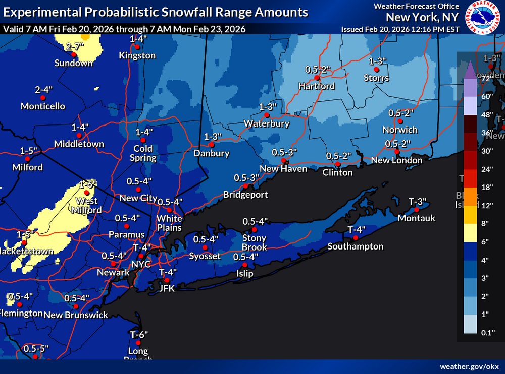
Where do you get those maps?
-
The odds of you being a whiff are going up!
-
YOUR THE ONE OBSESSED WITH WIND! YOU BEEN HIDING
-
It's safe to say the giants and the gfs have the same record
-
I think so. I haven't been in the islands in so many years like when I was a kid lol
-
Yes they mutual aided is for a tanker
-
Another day, another below 40 reading.... if this keeps up i don't think I'll be hitting 40 till March!