wthrmn654
-
Posts
3,953 -
Joined
-
Last visited
Content Type
Profiles
Blogs
Forums
American Weather
Media Demo
Store
Gallery
Everything posted by wthrmn654
-
So it's stronger correct?
-
45.3 montauk point
-
44 mph Montauk point
-
I kept trying press hold to talk but nothing would happen.
-
.KEY MESSAGE 2... Strengthening E-NE winds today into tonight could produce a surge of 2.5-3.5 ft, producing widespread moderate to locally major coastal flooding along the back bays of western Suffolk and srn Nassau, Peconic Bay, and western Long Island Sound, and widespread minor to locally moderate flooding in NY Harbor and Jamaica Bay, the lower Hudson River, and ern Long Island Sound. The main high tide cycle of concern is Sunday night. Areas of dune erosion are likely, with localized overwashes possible along the ocean beachfront Sunday night into Monday morning. Additional coastal flooding will likely linger into the Monday afternoon high tide cycle, with a strong northerly flow limiting impacts somewhat to minor/locally moderate categories. .KEY MESSAGE 3...
-
Winds gusting to 33 already out on east end. 38.7 mph at montauk lighthouse
-
Recon did flights over Atlantic earlier. May play into some models idk
-
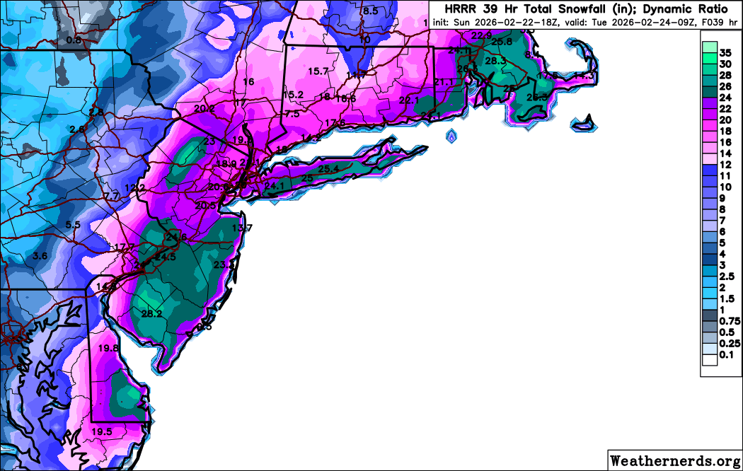
While the latest 12z GFS is now lower with QPF and more in line with the Canadian and ECMWF, these global models are struggling with banding. Current forecast QPF and Snow Amounts remained similar to previous forecast which is more in line with hi res/HREF guidance. Snow amount was derived using similar snow ratios to the previous forecast. Much of the guidance including the NBM appears to be too high. This was mannualy adjusted down to 10:1 or even a bit lower today, then increasing to 12-14:1 by late tonight into daybreak Monday as colder air wraps around the system. Using these ratios with generally 1.25 to 1.50 inches of QPF across the interior and 1.75 to 2.00 inches along the coast resulted in a swath of about 20 to 24 inches of snow for NYC and Long Island and 16 to 20 inches elsewhere. While this is the expected amount, a few isolated readings of 30 inches are possible in the heaviest banding, mainly along the coast.
-
Wow 18z hrrr is doubling down big totals on long Island.

-
Snowing in orient now 33
-
It's not done yet
-
Hrrr numbers are going up haven't finish the run yet.
-
33 and nothing yet. It's coming
-
If you're going say that say where you're talking about....
-
Days below 40 streak has ended today at 43.3°F impressive from Jan 22 to today .
-
Here's a little behind the scenes of what is going through a nws head tonight... Forecasting potential extreme events ("black swan" events as some call them) is always a psychological as well as scientific challenge. Yesterday I hemmed and hawed about mentioning blizzard conditions for Long Island for the upcoming storm and went with it in the end, the signal was too much to ignore. Now I'm confronted by the latest shorter term models, which refuse to back down from extreme snowfall amounts from Sunday afternoon into Monday morning. How much do I accept those amounts?? I think those models are seeing what the European model still isn't, and that's the potential for heavy thundersnow with rates of 2-4 inches per hour for several hours, preceded and followed by additional snow at lesser rates. The European never gets hourly snowfall rates above an inch per hour, and with an intense storm like this that makes no sense. But if I bought the extreme numbers verbatim I'd have to forecast at least 2 feet of snow for nearly the entire NYC Tri-State area, Long Island, and all of NJ, and locally as much as 30-40 inches for parts of the Jersey shore up into western and central Long Island. Nope that's too extreme. I can be conservative and say as much as 20-25 inches for the former and 25-30 inches for the latter, there is still time to zero in on the right amounts. If the extreme numbers don't back down with the daytime Sunday model guidance and I can still provide a rationale for why they might happen, then I may have to keep trending toward them. For now time to get some sleep
-
Not every station is on davis network
-
Digital access.
-
I should go to bed I got work at 6 am but I can't pull away... must watch.... models
-
Thank you!
-
Can someone please remove jersey shores comment, is giving my wrist carpool tunnel feeling, (idk how to spell that) every time I refresh and have to scroll so much! Also anyone else having issues with site lagging or getting host error?
-
I have access to multiple davis weather stations with good wind sensors.. montauk lighthouse, that had 81 mph gust this fall/ early winter, cross sound ferry, and possibly work weather station.
-
That indeed!
-
I think you posted one before a quote that messed up and took pages to scroll through. Your quoted post is very much glitched lol
-
If there's wind maps showing 75-80 you cut that back a little, that's all 60- maybe 70...