
cleetussnow
-
Posts
3,120 -
Joined
-
Last visited
Content Type
Profiles
Blogs
Forums
American Weather
Media Demo
Store
Gallery
Everything posted by cleetussnow
-
Holy shit
-
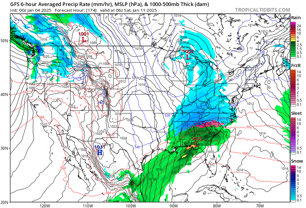
Gfs looking good. Sharper trough
-
The f’ing AI will troll us. They can turn on you. I saw a movie once.
-
This is something we can all get behind. I’m naming the Feb thread.
-
Appreciate you. Funny I was down there 3 times last year and it hit 100 every time. Snow was the furthest thing from my mind! Yet here we are.
-
Ummm. Winterwolf gonna wolf?
-
Bruh
-
Ha. My son goes back to school in Texas next week. He wanted to see snow before he left. meanwhile it might snow on him down there - he is on field training exercise (he’s ROTC) all next week…basically outside all week sleeping on the ground, no cover lol. Careful what you wish for.
-
I dunno. Everyone’s ill humored this morning but the GFS 6z got a smitch better vs 0z for the 11th. Week out. Maybe we see more moves like that this weekend. Didn’t see the euro -
-
Dr. no
-
Back to the weather …huge differences between the 18z gfs and 00z for the 11th. Not there yet but there is plenty of time ‘to get there from here’ so to speak.
-
Perfect post. Lets see if the Euro stays on brand.
-
Listen to what I’m telling you. There is a ‘big picture’ and it’s not a clown map. You’re looking at the least important thing rn. Go to tropicaltb, toggle the last few gfs runs and find whats different and figure out why it matters. We will talk about that here. The snowmap is not for discussion. Trying to help here.
-
The snowmap means nothing. Don’t post those anymore. Go find the H5 map and look at it. When you find the actually important thing on it, report back to us. That snowmap is baby shit relatively speaking.
-
Yeah mentioned the phase was going to be close in the NYC forum. And loandbehold. The southern stream is slower vs recent runs. Thisclose.
-
-
Trough orientation more negative tilted. Could mean its gonna climb and phase. I wasn’t planning on looking again..
-
This thread name needs a dirt nap. Mods?
-
Cosmic dildos Edit: if you’re into that sort of thing
-
Tips 15th system is there. Close to a phase on this run. Muddy looking rn. Looks better than anything preceding it.
-
lovely.
-
I am rolling my eyes. At the same time, something has to break our way...right?
-

Snowfall NYC subforum Jan 6 and OBS if needed
cleetussnow replied to wdrag's topic in New York City Metro
This time snow gets up to NJ. Its not a hit tho on the gfs -
Snowfall NYC subforum Jan 6 and OBS if needed
cleetussnow replied to wdrag's topic in New York City Metro
Gfs nudged it north. Give me another 60 miles…we can do that in 3 days easily. But that is a tight gradient so I doubt we will see huge moves beyond that though. This isn’t likely going to be much for the NE crew. -
Snowfall NYC subforum Jan 6 and OBS if needed
cleetussnow replied to wdrag's topic in New York City Metro
Little better


