

NittanyWx
-
Posts
793 -
Joined
-
Last visited
Content Type
Profiles
Blogs
Forums
American Weather
Media Demo
Store
Gallery
Everything posted by NittanyWx
-
So you're arguing a lagtime of two weeks effectively. Peak convection in this area is Jan 1-5. We got cold here Jan 14-20 and lingering into the 21st. Why was the lagtime two weeks and not one week? Most of the MJO lagtime papers argue one week. I've been on the receiving end of a lot of forecasts that purported to use the MJO for last week and extending into this one, and I can tell you that very few of them got the timing of this right, particularly when it came to the west and Canada. I can tell you why I made my forecast cold MLK week...it was because I saw an increased blocking signature developing first week of Jan, particularly Atlantic side and a potential for a displaced lobe of the TPV being cut off and pinched into western Canada and eventually that moving eastward. I saw the signal for this in late December, used it accordingly. The impetus for my view was blocking, which the MJO lagged signature incorrectly is predicting would linger into next week in the AK/EPO regions..it isn't. So if your two week (to be clear, this is the argument) lagtime is supposed to continue here, I'd be expecting an MJO P3 response next week, and I'd be expecting blocking to continue across the upper latitudes. Neither of those things are happening. What's the lag time now?
-
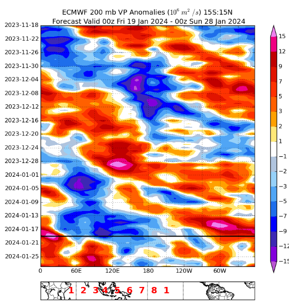
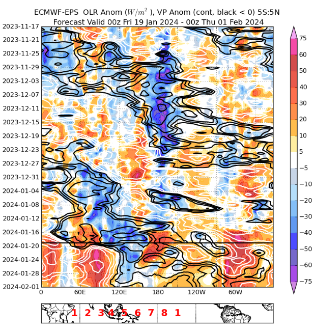
This is inaccurate. We had a >1 St Dev RMM phase 1 response for the majority of end December. By Zhou's definition for a coherent MJO signal, this is significant. I hate wheeler plots, but Zhou uses them for the MJO composites so it's worth remembering that. If you want to look at the VP space you had a coherent subsidence response in the maritime continent over peak warm pool areas in mid to late December: You can argue it was less amplified (true) but I don't view that as an incoherent progression in the VP space.
-
For anyone interested, there's also this paper on the subject: Time-Lagged Response of the Antarctic and High-Latitude Atmosphere to Tropical MJO Convection in: Monthly Weather Review Volume 146 Issue 4 (2018) (ametsoc.org) With this wonderful caveat: 'However, the time lag between the MJO and the Antarctic atmosphere has been found to vary between less than 7 and greater than 20 days.' Go forecast that. Impact could be less than 7, could be greater than 20 days. But don't worry, we promise this is adding skill...
-
I went back into my notes yesterday after you spoke about the lagged fast, slow response...i had a paper from Yadav on the subject: scholar.google.com/scholar_url?url=https://repository.library.noaa.gov/view/noaa/48317/noaa_48317_DS1.pdf&hl=en&sa=X&ei=nZKqZZTgGMrJy9YPkL-OiAY&scisig=AFWwaeYaGB4mXHwpJvzQ8GUFrEZc&oi=scholarr
-
Our peak warm spells this winter have been in MJO 8 1, what does that tell you?
-
The MJO composites you are using as the basis for 'what to expect in p3' are not lagged. They are the H5 pattern you get during the OLR/VP MJO identified week 3. This is, bluntly, a total cop out. I've read all this research on lagged response times and the lagged stuff Roundy uses wasn't any better in the polar regions. The answer, in this case, was the MJO P4 composites gave you a negative skill forecast for this week. What should be happening is dissecting what variables made that fail rather than passing it off as 'oh it's lagged'. You don't know that and when I ask 'how many days does it lag' you're essentially telling us the historical MJO composites are bullshit. I'll be blunt, I think a lot of people are learning the wrong lessons from this week.
-
\ We have composites built off of historical analogs for an expected h5 pattern during MJO P1, P2, P3 etc. We further filter them by El Nino/La Nina cycles, etc. Those analog h5 composites are used in predictive forecasts. During MJO P4 I should expect 'X' pattern. That's the point of using these analog forecasts. The pattern we are seeing now at H5 is not matching up the typical p4 composite. Roundy's analog work got the polar regions really, really wrong. So even the lagged methodology isn't working. Arguing that in this situation the cold we see now is a lagged impact /response completely ignores the fact that you're using a nonlagged composite as the basis forecast in the first place. So if you sat here and said i expect a P3 look when we're in P4...why do the analog cases argue the exact opposite? This is why I kinda get frustrated at how people use the MJO. If the response is lagged, why are you using unlagged composites for the MJO analogs? Like I think it's OK to sit here and say 'hey this didn't work, it's a bust this go'
-
For interested homeowners, where can one buy a weed zapping laser....
-
In recent times it is mostly Pacific differences (EPO region), differences in the strength/location of the PV, and also big differences in the amount of blocking.
-
I'm not sure what this post is responding to. The amplification of the VP signal over the warm pool wasn't ever in question. It was also further assisted by an equatorial rossby wave traversing the region too. Once again, all play a factor. What I was questioning was your comment that the MJO 'slowed down' this year which led to extra warmth. There was no 'slow down' in this sense of the VP anomaly signal (as we define it). It did a full cycle at a fairly quick rate of speed and was pretty coherent throughout. You saw the OLR response as well. So that theory of 'slowing' isn't really an accurate way to describe December. Highest amplification/VP anomaly in p7 is absolutelty correct, but the MJO slowed/stalled? No. Further, I'm making a comment about sub-seasonal forecast usability at the weekly timeframe above all else here and pointing out that 2002 didn't have the depth of that warm pool response, but did have a Modoki signal to achieve a very similar OLR result. The temperature pattern was not nearly as amplified warm in the northeast and east in general, which speaks to potential bg warming climate itself, a dislocation of cold air on this side of the pole (for several reasons) and an h5 response that, while may have looked good to some on the EC weeklies, ended up advecting mP air with a displaced PV on the other side of the pole. For what it's worth I had a very warm December as well and also faded very aggressively the last week of December as you may remember. Had I been one who believed in p8-1 VP anomaly traversing eastward (as it clearly did) as the primary driver for temperature regime change, I would've been one who would've 'bitten' on the cold for Christmas werk. This was my real point about sub-seasonal bust potential following the agreed upon MJO/GSDM methodology. You had colder phases, you didn't produce expected results during the 'colder' phases for several reasons. This is why it's just a piece of a forecast puzzle and not a sole driver. There is a strong seasonal correlation to warmth in December El Nino's nothern tier and west, so most forecasters who do their homework should've been warm to very warm nationaly (there's also a seasonality to eastern warmth the week around Christmas too in Nino's). But I do question the validity of blaming the amplitude of the warmth solely on a highly amplified p7. There was more to it this season and it was pretty clear early on.
-
This is fairly similar to the 02 Nino forcing. 02 definitely didn't have the W Pac warm pool assist to the level of this year, and wasn't as warm in the east, but thought it's interesting.
-
Again, I'm not dismissing the science behind these ideas, my question is as an operational forecaster, is it actually helping you if you're wrong on key synoptic features and timing and using that as the primary basis for your forecast. How you decide to forecast is your own decision and I'm up to the individual forecaster. What I'm seeing myself is throwing into question the efficacy of it's usage for operational purposes when benchmarked as THE primary forecasting basis.
-
Not sure I'm really seeing that signature here for Dec, do see a Nino standing wave though and some hints of 30 day MJO cycle...
-
This is not a shot at Paul because I understand what he's trying to do, but according to this methodology, I should've expected a ton of ridging in Alaska and Greenland next week, a big trough Aleutians into Japan and the models today have the exact opposite sign in these very important polar areas, which are of key use for how we forecast the synoptic pattern
-
OK, so how many days is the lag? It's totally dependent on the pattern, speed of forcing, amplitude and interference/noise from ERW/KW right? This is the issue I have with some of this stuff because when we look at phase diagrams and h5 analogs we are often looking at 'same time' in the analog cases. Yet, when the analog fails, there's a lag, how much is in the eye of the beholder. For operational forecasting purposes, how are you supposed to beat the model with this form of forecasting? Like I think we are very kind at explaining away failures with this methodology and there's no real hard and fast rule, and that's how you get into timing is wrong, which means a forecast bust. Like this ventures into the 'oh I'm right, but wrong on timing'. 'Cold is coming eventually' and being off by 6 days isnt a good forecast... How many times this winter have folks used the MJO and just flat out whiffed on the temperatures associated with the given pattern? I think in terms of operational mid to longer range forecasting and I'm not convinced the methodology leads to more accurate results. I've been doing this for a long time too so I have a pretty big sample size.
-
There's also the ever sneaky bg global warming which is occurring too. Even the guys who don't believe in it are using trendline forecasts when making seasonal HDD forecasts which is their tacit acknowledgement that they can't ignore that contribution anymore...
-
Without giving too much away, there's actually quite a strong correlation to USA temperatures/degree days and stratospheric temps in the preceding month(s) for December, and that correlation strengthened significantly this year. When I bang on about source region and questioning cold displacement this is certainly something I look at closely. This is one example of about 3-4 others that I think have a physical role to play in development of the PV and displacement/location thereof. There does seem to be a tropo connection to it (wave breaking another crucial one). Indian Ocean Dipole/ENSO modulation of tropical forcing has a role to play in contributing to those warm winters too. What I look for are multiple signals pointing in the same direction for higher conviction forecasting. What I'm saying is GSDM/RMM based forecasting as the sole basis for a view has, historically, had a high bust rate...particularly in regards to timing which is often smoothed over as 'was right, just wrong on timing'. Not to burst anyone's bubble, but if you're wrong on timing, you're wrong... There are sub-seasonal influences all over the place. But generally speaking strong ENSO winters tend to be higher conviction forecasting because of the known correlations globally as well. There's always sub seasonal variables that modulate it though, and the key is to pick out what's a legitimate signal vs noise that can fuck up a forecast.
-
Yeah we can test that via historical ERA5 data, would be interesting to see the difference in h5 response with 30-40 day cycles vs slightly longer.
-
I don't want to sound dismissive of tropical forcing, it's got a role to play and a crucial piece of forecasting in the extended range. But the correlations are often overvalued by forecasts at the mid and high lats, especially in recent times. In my opinion the guys who use it as the foundational/principal basis for the majority of their forecasts tend to overvalue it's usefulness. More pieces to the puzzle. It's not the answer to all weather and it gets that reputation sometimes.
-
We're sitting here at MB's in a p4/p5 right now too...
-
Our coldest week of the year has come in P3/P4. Other atmospheric drivers will have something to say here...
-
Worth noting the amount of low level cold in this synoptic setup and the storm track H5 creates during the 'relax' period at 500. Could lead to an icy situation. Lotta HP in eastern Canada. Periodic reminder we don't live at 500mb
-
 Looks in line with expectations honestly. HRRR has a good handle on mixing
 -
This particular issue was a function of underdoing the upstream plains trough. Something it has done during nearly every significant arctic outbreak into Texas over the past few years. As the model recognizes the depth of HP/cold closer in, track gets closer to the coast as pattern becomes more amplified.

