NittanyWx
-
Posts
793 -
Joined
-
Last visited
Content Type
Profiles
Blogs
Forums
American Weather
Media Demo
Store
Gallery
Everything posted by NittanyWx
-
I don't think the MJO 'slowed' at all. I think you had a Kelvin wave continue to traverse as expected, but the signal was overamplified by modeling. It was less coherent as you rolled forward. I also think the biggest issue was PV displacement on the other side of the pole. Can't blame that entirely on tropical forcing. It was a source region issue. I asked this same question when the weeklies were showing this +PNA for the last week of Dec...what air are you advecting?
-
Ongoing source region issue, and will continue to be an issue in early Jan.
-
I think the best way for this to change that is PV consolidation and then some sort of Aleutian ridge to displace it towards NA. Need to have the cold air shunted towards NA after this coming PNA spike to fix the snowcover issue.
-
The Indian Ocean Dipole. Coupled atmospheric/ocean temperature pattern, measured by the difference between ocean temps off the coast of NE Africa and Sumatra. Indian Ocean climate influences (bom.gov.au)
-
He's making a fair point about the seasonal IOD collapse and subsequent weakening of the standing wave signal in the IO. Not sure that's necessarily the way out on it's own like he's indicating here, but the path analysis to source region shift makes sense conceptually.
-
Sure, in certain instances it doesn't work out with a colder Canadian airmass nearby to tap into for a plethora of reasons. We have certainly seen cases where promising Canadian airmasses and cold air supply are accompanied by jet suppression. However, historically, patterns with a normal to cooler than normal Canadian airmass providing available air to tap into are significantly better performing for the local area than alternative when it comes to snowfall. At least I've certainly found that to be the case in my career. You're talking about statistical odds. As I discussed yesterday, no one is saying it cannot snow ever in this pattern, I'm certainly not and I do like the 500mb pattern from a 1000 foot view. But it's not unreasonable to say it is statistically less likely than the alternative.
-
Missing Canadian HP from your equation.
-
Persistence forecasting for persistence sake is normally not a smart way to go about things. However, in certain patterns in certain years you can meteorologically have a good reason for going with it. That said, it depends on the meteorological variables on the board at a given time. I think there's been several years where if you took the persistence view on an extended/monthly basis it worked significantly better than trying to force a pattern change for X reason. I personally need strong evidence to copy in a persistence view, but I've certainly had bimonthly periods where I felt the pattern was just stuck, I had no real reason to believe it would change in any meaningful way for any appreciable length of time and went with it on a longer range basis. Yeah, there's some inherent variability in there for small windows but the big picture monthly degree day view made it somewhat negligible. For the record, I'm not taking the persistence view today.
-
I also agree.
-
I don't disagree here, but persistence is a view and sometimes it rewards a forecaster who has a healthy dose of skepticism. It works until it doesnt.
-
The timing is literally half of the forecast verification, but to some it is a fungible concept
-
There's a large temperature spread between this December anomaly and the number's you're talking about. However, historically we do better when there's a source airmass in W Canada. I'm pretty clear in that I think the PNA is 'favorable' for a stormier solution, source is not favorable for a decent cold air supply and that leaves us with chances for snow, but less room for error.
-
I agree with this, but I also think people need to stop being so sensitive when it comes to pushback on that snow idea. If someone who's done this for a long time comes out and says 'I think that's wrong and a bad idea', it's not shutting down debate. It's literally the debate process. If you've got a view, take it. If someone pushes back on your view that's not shutting down debate. I'm sorry, but you're going to get challenged if you're going to make a forecast. Need to accept that. Especially if you continually have the same view and it blows up in your face. What I don't accept however, is selective verification. Far too many people try to convince people they were right after the fact or come with 'well I was wrong on timing and right on idea'...guys timing is as important to the forecast as the directional view.
-
2015 and 1982...wonder if those years have something in common with this one
-
I'd rather have a quote tweet reply from pretty much anyone else other than BAMWX
-
I think on the surface a reversion to +PNA with some sort of trof in the east is justified view for early Jan. There is a lack of significant source air to advect however which has been a common theme. Now if this PNA spike ends up being more GOA focused, perhaps there's an ability to dislodge some colder air. But in stormy situations with marginal airmasses, relying on a lot to go 'right' to thread the needle. That's where my head is at right now. I still see source region issues.
-
So just to update my thinking here from a few weeks back...we're in our much above normal temp phase post mid-month transient cool shot. Now we're left with the following: still no significant source region in Canada, dire snowpack in the mid-con and while we're seeing a PNA spike on most models...it doesn't have much of a source to tap into. I think we are likely going to see an erosion of the much aboves heading into early January, but I'd be lying if I didn't say I'm not loving what source air there is to work with at this stage and was a little more hopeful to see the EPO region shaken up instead of the bulk of this PV piece retro'ing back to Siberia. The EPS has been struggling, significantly at that, with 2mT cold bias so far this winter. I suspect it's doing so again late 11-15 day. That said, I am expecting to see the much aboves ease off a bit. H5 improvements are likely in early January. Tropical forcing should be more C Pac/E Pac based as well, but lacking available cold air to tap into I don't see much more than a marginally cooler period ushering in the first week of Jan.
-
There is an inherent disbelief in his post that a clear climatic trend is occurring because we somehow don't know what happened more than 150 years ago. It was a silly statement and wrong.
-
Lol what? I gotta ask, who told you we have 'no idea' of what happened more than 150 years ago?
-
It's not unique to NY either. Single day rainfall records are being broken and an increasing rate over the past 20 years. It's one of the cleaner climate change signals we have and passes the scientific sniff test.
-
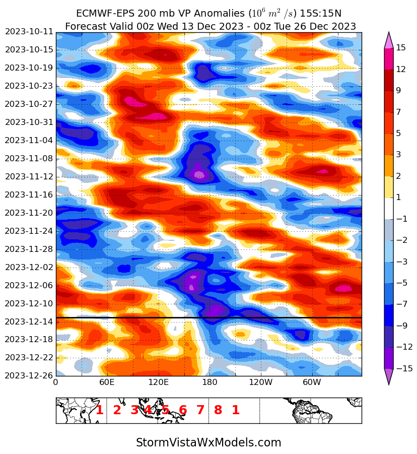
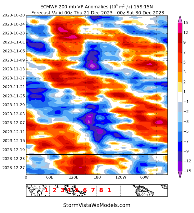
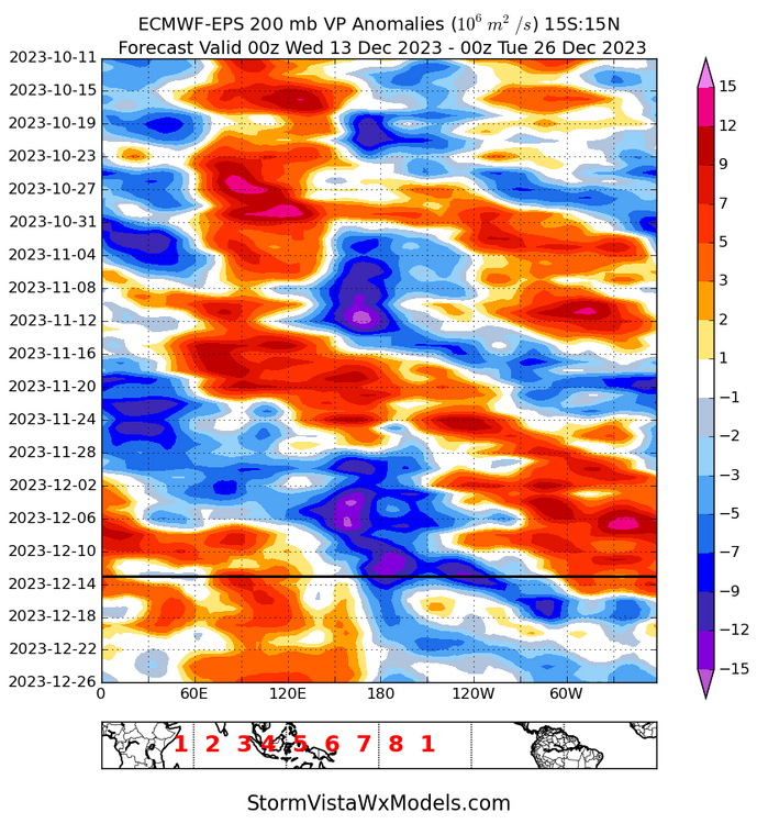
The more 'favorable' VP anoms did progress as expected. I do think the MJO signal was overamped and overhyped as a function of the pair of tropical cyclones and a Kelvin wave, but this was a pretty clean 200mb VP signal. I don't think this failed in that sense.
-
Yeah for Feb sure, was more talking Jan since that's where we kicked the can to at this point.
-
Just curious why you think it's the strato that's needed? We've had blocking over the pole and SSW's are mostly viewed as a way to weaken the PV to allow for more blocking. There's been the -AO, there's been a -NAO...to me this needs to be some sort of wave breaking signature to change things in the Pacific since default state in Nino years like this is +PNA. PV splits have a loose correlation to cold roughly 24 days after they occur, but that would then be kicking the can more to Feb, no? If you're looking for Jan help it's gonna need to be some combo of Pac changes in conjunction with dislodging some cooler air. I think you're on the right track with the idea of jet retraction, since in my mind the way for this to happen is retrograding +PNA which amps into AK and finally dislodges some cooler air and aims it towards NA.
-
Yes I agree its a better look synoptically in terms of shutting off the Pac flow and potentially dislodging something colder out of the artic and pushing it towards this side of the pole. Maybe not hammer cold, but an erosion of the much above. When we spoke 10 ish days ago, i felt the way to do this was with some sort of PNA retro, amp into AK after jet retraction and the Kara Sea piece allowing for some cold to be able to be tapped. This is in a way similar to that idea and an important step in this process. Split flow would increse the odds that pattern would deliver some sort of storm with as you head into that Jan 5-15 window. Let's see if it rolls forward. As I said before, I'm in the agnostic camp at that range.
-
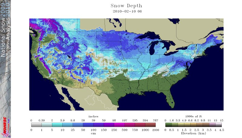
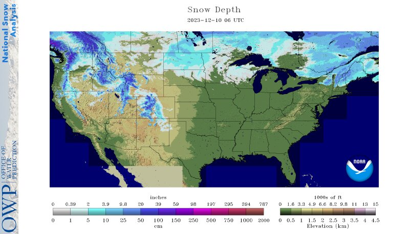
Couple things...first, you had a midcon snowpack then: Vs now: And really my point a couple weeks ago was 'what air are you advecting?' when you went back to a +PNA for that Christmas week. Not saying it can't snow from a one off, but I am saying this current setup that was shown for the last week of Dec wasn't a modeling error. It actually looks like a really good forecast. So now it's really to me about finding a way to dislodge that extremely +EPO and also weaken that Pac jet extension. Yeah i don't think climo supports the Pac jet staying extended for long, but I still am of the belief that some source region is needed after the Pac air floods most of NA. It's possible, but I really do believe if you want a prolonged snowier period in this type of climate you need some Canadian HP and it would help to have some form on a midcon snowpack that is usable in a baseline +PNA scenario. I'm agnostic at the moment. Think both things are possible, but I'm not at the probable stage until I see some changes in the AK region.