NittanyWx
-
Posts
793 -
Joined
-
Last visited
Content Type
Profiles
Blogs
Forums
American Weather
Media Demo
Store
Gallery
Everything posted by NittanyWx
-
Also, for the life of me I don't understand all the fighting about which phase the MJO is in and how phase 8 fixes everything. You need a loading pattern for a source, you need a source region regardless. That source region can come from wave breaking, stratospheric fluxes, etc etc. Feel like in winter everyone thinks the MJO is the solution to all problems and I don't think that's necessarily true. December's are tough in Nino years as the continent is often flooded with Pac air. We're seeing that play out right now.
-
I see a lot of Nino standing wave here. Which isn't terrible in most circumstances and you can get some Kelvin waves to leak east out of that. But, and I'm gonna keep saying this, we need some help with source region and building some snow pack to the west still, in my view before I can start to take storm risk seriously. It's not an all out torch, but it's still relatively mild.
-
It's gonna take several steps for this to improve enough where you'd trust a pattern to have any meaningful cold with it. That's the issue with these setups and its the issue with any coastal next week. You don't have much of a source to work with.
-
We're in an El Nino, a strong one.
-
I've seen weather vendors amplify this idea on the energy side too and they're getting run over right now because they're all too cold. Some people live solely inside the VP space as if it's the god particle that solves all weather.
-

January 28/29 Blizzard Observations/Discussion/Nowcasting
NittanyWx replied to Northof78's topic in New York City Metro
Sitting in some heavy subsidence. Very tiny dendrites. 18 and windy. -
I'll be sure to tell my cloud microphysics teacher. Look, I'm kidding a little bit. I've basically gone 'this is a Hatteras to benchmark low, it's gonna be a sizable storm for many east of 287' since Wednesday. But the northwestern component is an absolute nightmare with this and the comms around that are super difficult. I'm glad I don't do TV for events like this.
-
I have a stupid job. Do the weather they said!
-
I just want to caution folks on aiming too high on these ratios again. I think 12:1 is a solid middle ground and reasonable right now. Just too much wind. That said, this is a clear warning criteria storm east of 287 and a monster for SNE, Suffolk and some of the jersey shore.
-
I dont know yet, but my instinct says I can't totally toss out a gradient line starting at just west of 287 in Jersey yet. This is a very tough forecast.
-
Same issue with the dendrites getting beat up. Perhaps even more so. You'll just have way more liquid to work with.
-
Using 12-1 ratios because the wind is gonna beat up these dendrites. 10+ island and much of coastal NJ and coastal CT seems fair. It's that sharp gradient keeping me up right now. I'd love this to tuck 20 miles further west just to make this a bit more straightforward
-
Most of the downstream changes are a knock on effect of subtle differences occurring inside hour 72 with regard to that northern stream piece. It's becoming a bit less theoretical today. Still some time for it to change again, but inside 72 you tend to look at it as a bit less theoretical vs trend tracking.
-
That shift in warm nose at 925/850 made a huge difference up there. Nice job by Albany on seeing that early yday.
-
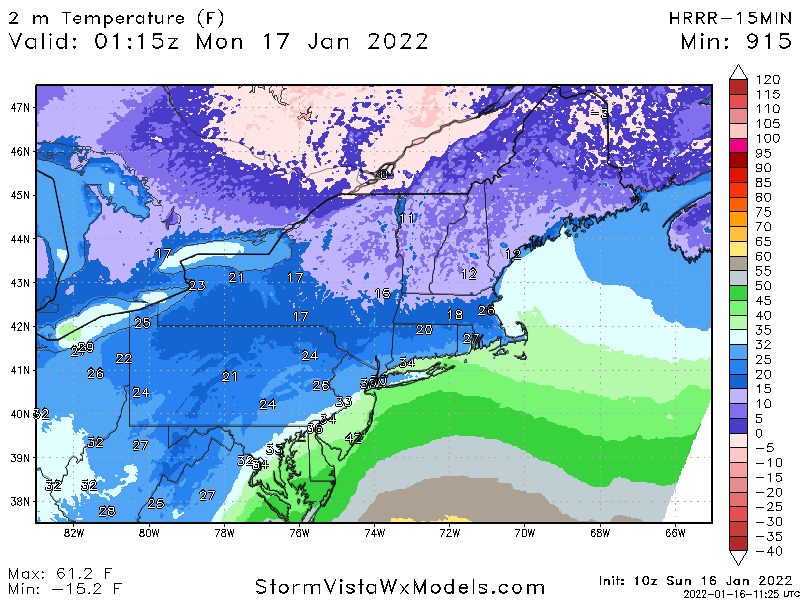
Precip timing was fine at the 10z cycle, it has 0.1LE a little after 9 in the city and S Westchester closer to 10. So pending SWE it could end up a bit too dry if anything. But as far as temperatures go and the coastal front, that was handled well.
-
You were repsonding to a post of mine talking about the performance of the model with the coastal front. From there went on about how the 21Z HRRR 'showed no snow', which is just flat out wrong. It also kept Ptype as snow through 9pm, or roughly 2 hours. LE may end up around 0.1", which is where the 21Z HRRR may end up underperforming. If you would have said that, I would have agreed with you...
-
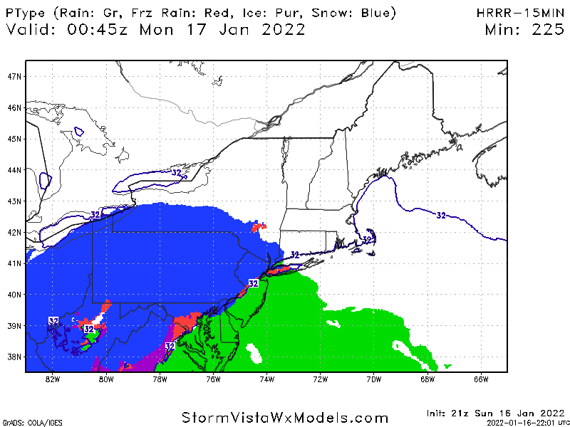
Depends on which model. Here's what the HRRR had this morning for right now: I'm a big stickler on revisionist history in this field and will call it out every time.
-
For the record, the HRRR has been showing this starting off as snow pretty much all afternoon... Use the clown maps at your own risk. But it's straight up false to say it didn't have this starting off as snow for an ay least an hour via the 21z run. 29/25.5 in Wilton, light snow.
-
That gradient won't last very long. The HRRR has been pretty good at modeling this coastal front
-
95% of the metro area looks in line to be above freezing by 11:30. Orange County and maybe the hills of Sussex the exception. Storm behaving as expected.
-
Looking at some upper 20s and 30 degree readings into lower Manhattan.