

NittanyWx
-
Posts
793 -
Joined
-
Last visited
Content Type
Profiles
Blogs
Forums
American Weather
Media Demo
Store
Gallery
Everything posted by NittanyWx
-
Friends don’t let friends use the NAM. That said, this is clearly a major storm with a lot of 1-2ft amounts and drifts much higher than that. This storm also has a band that will produce 3”/hr rates
-

Extreme Cold, Snow & Sleet: SECS 1/24 - 1/26
NittanyWx replied to TriPol's topic in New York City Metro
Agree, what happens south of the Merrit and between 287 and 80 is still a big questionmark -
Extreme Cold, Snow & Sleet: SECS 1/24 - 1/26
NittanyWx replied to TriPol's topic in New York City Metro
Risk here is primary handoff to coastal and slotting. I think coastal areas, especially Jersey and ELI have a period of sleet, but the slotting on Monday with primary handoff is a tricky feature. Should still be a very solid event, just a mater of top end -
It's got all the pieces. I feel good about being a bearer of good news when we're able to sniff these out a couple weeks in advance. I've had to shit all over a few of these longer range patterns in recent years when people were getting too far over their skis on the weeklies and it's nice to not have to do that right now into early Feb. The snows this past weekend and now this weekend and likely next weekend kinda solidifies the meteo still works even if the models may not have the handle on it.
-
I would expect some sort of warmer correction and a pullback between lobes of cold air injections. Timing that out is tricky, but might be that late 2nd into third week of the forecast. That's always tough to pick out at this range.
-
I'm still here, and I'm thinking this pattern lasts into early February as well. Several chances outside of just this weekend.
-
Maintain the view of a more active southern stream with cold air nosing into the northern tier and potentially into the midcon. MLK weekend is the start of our best pattern potential for higher impact snow storms in quite some time. Pieces are on the board, it's a matter of putting them together.
-
Source region is rebuilt in western Canada by MLK weekend, offering a new cold air supply that should leak into the northeast. I am seeing more signals for active southern stream as well. Think end Jan to early Feb looks pretty decent setup wise at this early juncture as well.
-
January 2026 regional war/obs/disco thread
NittanyWx replied to Baroclinic Zone's topic in New England
Seems a pretty straightforward setup for back half Jan, rebuild source region in western Canada late next week/weekend, likely leaking cold into the northast at times with GOA ridging (-EPO) beyond. Chances for coastals during transition periods, and perhaps a more active southern stream from MLK and after. -
Afternoon runs starting to really coalesce around building the source back. This thaw should have a limited timeframe assuming that's right. Nice to see that around d 10-11 now
-
This next +PNA lacks as much of a source region cold out west and as much HP associated with it, hence the chinook look to things midcon. In theory that should mean less in the way of the vodka cold/dry in Jan that was a staple of much of December. That source region should slowly start to rebuild around MLK weekend and i suspect youll have a hard time keeping the northern tier from leaking colder once that piece returns.
-
Huntington Bay NY SN
-
standard NYC snowfall pattern.
-
Found it interesting that this was another event where a couple AI models kinda sniffed out the trend a run or two before the globals. That said, I think the Euro got its shine on this one.
-
Wilton CT 32.7/32 Coating SN
-
I tend to agree, it's a very fine needle to thread. I do think a light snow event via suppression is more likely than a Boston bullseye at this moment though. But to me the suppression risk and a miss is the real risk here...much more than p-type cutter.
-
I'm in the camp that risks with Boxing day event point towards more suppression vs P-type actually.
-
Moderate snowfall 12/14/2025 WWA up for most of the area
NittanyWx replied to WeatherGeek2025's topic in New York City Metro
First big win of the winter for the AI models. Plowable coast. AIFS in particular did well in digging the SW and turning the trough more neutral vs positive a couple days back. -
Moderate snowfall 12/14/2025 WWA up for most of the area
NittanyWx replied to WeatherGeek2025's topic in New York City Metro
I like the slightly more amped trends we're seeing today as well. -
Moderate snowfall 12/14/2025 WWA up for most of the area
NittanyWx replied to WeatherGeek2025's topic in New York City Metro
I again point to the deep DGZ with this and think fluff factor will help. -
Moderate snowfall 12/14/2025 WWA up for most of the area
NittanyWx replied to WeatherGeek2025's topic in New York City Metro
I like the depth of the DGZ with this one. A little liquid goes a long way. Great test case for AI modeling here with the more amped and juicier solution and a notable difference in trough tilt. I think this is a measurable one for the coast at least. This vort here is holding the keys to the difference in more neutralish rough tilt vs more positive. I don't know the answer yet on whether AI is better poised to be the better predictor vs NWP on trough axis tilt and whether this is a use case where it has skill. I do know the Euro is further north than the GFS at 48 hours, has a less positive tilt and if I'd have to guess in most cases the trend in recent years is north late. I wouldn't necessarily dismiss plowable fluff at this stage for the coast... The confluence near us is the counterargument to that.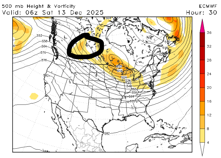
-
You posted a relational inference based on observed data, yes We're not arguing about that.
-
Yeah so my only point for this is if there's really something here I think we'd see it in actual statistical correlations with ENSO to snowfall. Whether that be rate of change of ENSO over the winter, a linear or partial correlation between regional observation and ENSO value itself...just something there that's more robust and can give us something to really sink our teeth into and find out what it's telling us and why. I think your points here aren't far from where I'm at too. But I'm more curious as to thought process above all else to see if there's something testable.
-
Asking you about your methodologies and whether they actually make sense meteorologically or whether it's an overfitting of observational data is stirring up controversy now?
-
Posted through the entirety of last winter and had a very good one forecasting wise. Had a very good one the year prior too.


