stormy
-
Posts
2,000 -
Joined
-
Last visited
Content Type
Profiles
Blogs
Forums
American Weather
Media Demo
Store
Gallery
Everything posted by stormy
-
I received .95. Wonderful!!!!!!!!!!!!!!!!!!!
-
The NAM 12 picked up on the activity in my area this afternoon. The high Res. NAM 3 did not!!!!!!!!
-
.51" rain from 2:30 - 3:00. The most from one event in 50 days!!!!!! .75" on June 5.
-
Potatoes are easy to grow in Va. I have been doing it for decades. Put seed potatoes in ground about May 1 and dig early August after vines have died down. They need lots of rain or watering when blooming. I have dug a big bushel in the past week and probably have another bushel to go.
-
.04" from that flood watch!!!!! It's always less than .10"..............................
-
STERLING and NOAA are a complete Joke................ Their government subsidy is a complete fleecing of America as Brokaw used to say.........
-
Happy for you................. I have had .40" in the past week and nothing in the past 24 hours.
-
.40" in the past week here.
-
I received .25" while Buffalo Gap received 3.14"!! and Churchville 1.76".....
-
If we're still dry in September it will only get worse without tropical contribution. Historically, September and October are very dry without tropical contribution because the thunderstorm season is over...........................
-
Its been raining off and on since 8 am here and I have all of .04"
-
Light rain begins with 70 degrees. The GFS gives me .08" during the next 24 hrs. and the ECMWF gives .26"................ .43" so far for the first 20 days of July. Normal would have been 2.80".
-
Last year April /May and August thru October were very dry. June and July were wet at my place. This year I have received .43" the first 18 days of July. Last year I received 4.64" the first 18 days of July! During the past week, southern portions of Augusta have received 1.00 - 2.00" of rain. I have received .09". Currently, we are suffering an extreme agricultural drought. Hydrologically, we were worse last fall.
-
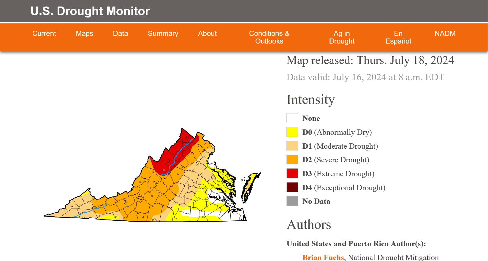
The updated Drought Monitor places the 81 corridor from Staunton to Winchester in Extreme Drought

-
I have received a pitiful .04" as most of the energy translated south of I-64.
-
All of the CPC guidance says cooler and wetter from Saturday into August. Are these people worth their positions??????????
-
If we had received the predicted rainfall from the 6-10 or 8-14 during the past 6 months, we would not be in drought.
-
Believe it or not, the USGS test well about 15 miles north of Waynesboro at 310 ft. is about the same as July 15 of 2023. The water table has fell about 6 ft. since May 25 but is 15 feet above mid November of 2023.
-
.07" yesterday. 19% of normal rainfall for the first 13 days of July.
-
12z models give my area .05" to 1.00" on Friday with a suicide demarcation.
-
I have received .27" rain the first 10 days of July. This is the driest first 10 days in more than 45 years!! Number two was July of 1998 when I received .62".
-
Those were my expressed fears from last weekend. My 3 model blend has collapsed from 1.50" to .37" during the past 24 hours.
-
Interesting question! The 15 90+ days in 1934 had an average low of 66. The 13 90+ days in 1936 had an average low of 63. The average low for June 20 is 60.
-
I have recorded 9 days since June 1 of 90 or above. The 1930's were hotter as 1934 had witnessed 15 days of 90 or above on July 9 and 1936 had witnessed 13 days of 90 or above at Staunton by July 9.
-
The 12z AIFS is better than the deterministic Euro, giving our area an inch of rain by late Friday.