

stormy
-
Posts
1,012 -
Joined
-
Last visited
Content Type
Profiles
Blogs
Forums
American Weather
Media Demo
Store
Gallery
Posts posted by stormy
-
-
22 at 7 am.
A soaking rain will really help with the very dry conditions, smoke and wildfires.
A 5 model blend gives D.C. 1.65" and Augusta 1.02". All important Luray receives 1.23".
-
4 hours ago, Jrlg1181 said:
Can't speak for him, but we kinda need Friday night to come to fruition out here for rainfall.... Right at 2.71 total precip since January 28th.... With another day here with winds gusting in the 40s and the growing season starting - Its drying out pretty fast....
Your intelligence is bold face. The other Clowns are to be discounted.
-
7 hours ago, snowfan said:
GFS was like, just kiddingggggg.
Oh well, I'm more interested in a soaking rain. Waynesboro has declared an outside burning ban because of how dry we're getting.
My latest 4 model blend gives Waynesboro .89" Friday night/Saturday. Nice!
-
28 early this morning is a lot better than 12F at the summit of Spruce Knob. Rt. 250 is covered with snow at the Va./W.Va. state line at 4332 ft.. Looks like maybe an inch.
-
12 hours ago, Ji said:
Where is this at?Elliot Knob 20 miles west of Staunton is 4463 ft. and expecting 4.4 inches of snow Friday night. Hike to the summit. Reddish Knob about 20 miles north on the Augusta/Pendleton county line at 4398 ft., has a narrow paved road to the summit with large potholes.
-
 2
2
-
-
1 hour ago, CAPE said:
It isn't going to snow anywhere near Staunton. He can drive NW towards Canaan if he wants to see snow. NW and 3000+ ft is where accumulating snow will be. This isn't difficult lol.
On Sat. morning I can drive to 4400 ft. withing 20 miles of my place. A lot better than 95 miles to Cannan for 3400 ft.. , 1000 ft. lower. Of course that would be 70 miles n.w..
-
1 hour ago, CAPE said:
Good luck.
Thanks Cape. We both know this is not likely to happen. The 18z GFS has dropped from 5.0 to 2.9" for Augusta.
But, during a slow week, it gives us something to chat about.
Wow! the GFS increased from 1.38" to 2.04" qp for Augusta!!!
-
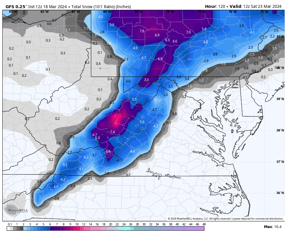
The 12z GFS and GEM runs are becoming a little more bullish on the WOTBR snow threat for Friday night, both op and ens.
GFS op - 3- 5" both 10:1 and Kuchera qp 1.38" previous .65"......... GEFS 1 - 2 " previous .3" ......qp .55" previous .30"
GEM op - 0 ................ CMC ens .8" previous .4", qp 1.05" previous .60"
ECM 0 ECM ens 0
A long shot but the trend is my friend.
-
 1
1
-
-
12z GFS still likes accumulating snow for the Valley Friday night. Quebec high, ENC low, timing could work.

-
This looks fine for Friday night in Augusta County. Track of lp is encouraging.

-
1
-
-
A high of 70 on Friday felt wonderful. Of course, that was cool compared to 1944 when it was 86 in Staunton! And warm compared to 1993 when it was minus 3.
My peach tree will be in bloom in another week or 10 days. Apples and plums later.
Most fruit will freeze this year.
-
1 hour ago, Maestrobjwa said:
This is the part of this new...whatever it is I don't get: Why is it that these late freezes have become more prevalent while the winters have been warmer? Although I think @psuhoffman said the Springs aren't getting cooler by the numbers...but why then are we seeing this more? Like...shouldn't a warmer background mean this doesn't happen as much? Make it make sense, lol
You are wise to question theory through observation.
50 years ago the accepted last frost date for my region west of the BR was May 10...
Today, horticultural experts have moved the last frost date to May 15.
In the fall the first frost date usually comes 10 days later than 50 years ago.
-
On 3/14/2024 at 4:26 PM, psuhoffman said:
I am going to address this and your previous post here.
From 2014 to 2018 was a positive PDO spike and taken as a whole was a very snowy period. From 2007 to 2013 the PDO was negative and other than 2010 those years all sucked.
There is more to the PDO than the raw numbers. It is also NOT a magic bullet operating in a vacuum. But if you look at the last 5 deeply negative PDO periods, they all sucked major ass wrt snowfall here. 1949-1957, 1971-1976, 1989-1992, 2007-2013 and 2020-2024 were the last 5 deeply negative PDO periods and they all were incredibly low snowfall here.
But the PDO is not the end all wrt snowfall. We can get a +PDO low snowfall season if other factors are not good. A +AO can offset a +PDO, for example. And we have in the past been able to get a snowy winter in a -PDO, but those mostly came during weak or moderately -PDO periods not strongly -PDO cycles. Look at the 1960s for example...and the snowiest seasons came early in the 60s when the PDO was positive...yes it remained snowy into the -PDO cycle later but it was a weak to moderate -PDO cycle NOT a deeply negative one. Once the PDO went deeply negative in the early 70's the snowfall stopped!
There is a matter of degrees to this. No one factor makes up 100% of the equation wrt our snowfall. But what the last 75 years suggests is that when the PDO goes into a deeply negative cycle we are in big trouble and it tends to suck. A deeply negative PDO cycle seems to overwhelm the rest of the pattern and it's very hard for us to get much snow regardless of what those other factors are doing during these ---PDO periods.
When the PDO improves does it mean we suddenly get a ton of snow? No. We might get a +AO season, in which case the PDO won't matter. The truth is we are south of where it reliably snows and so we need multiple factors to line up in order to get snow. But one of those factors is the PDO and it would be very helpful if it would get out of the suck ass phase that it is in now.
Thanks for this wealth of information!
The 50's and 60's gave me a cautious attitude about PDO influence because most of the 50's averaged -1 to -3 (snow drought) then + 1 to +1.7 from late 57 - 62 snowy , then negative again -1 to -2 for the rest of the 60's which also produced some cold snowy winters.
I am beginning a study of AO/NAO influence on MA winters and will have more comments as my study bears fruit over time. An early on empirical snapshot tells me that the AO is usually a more reliable factor than the NAO.
-
17 minutes ago, cbmclean said:
I don't think anyone has been touting the PDO flip as a magic elixir, at least not in any of the serious posts I have been seeing. The general theory (and hope) is that some of the suck we have been seeing in the last ~8 years is due to a prolonged period of very negative PDO and that when that relaxes we may see some improvement. I don't think many are expecting it to go back to "normal". It just MAY not suck so bad.
@psuhoffman has been the person I have talk most about this topic and he has made it VERY clear that he believes that at at best a +PDO will only mitigate the suck and that there are non-cyclical factors leading to an ever-worsening base state, which is my own belief as well.
What impact, if any will a +PDO have? TBD.
The current "deeply negative" PDO began in 2020. That is only 4 years ago. Prior to that it was moderate/strongly positive. During nearly all of this time we have been well below normal snowfall whether or not it was cold enough to snow. A lot of this has been dependent on timing and track of precipitation bearing systems.
-
17 hours ago, stormy said:
You seem to be confident that a PDO flip will make a difference. I'm not convinced.
During the past 100 years, other factors have resulted in snow droughts for 10 years or more.
Please give me examples of how a positive PDO enhanced snowfall.
Regardless of your theory, I'm not convinced a positive PDO will be the magical elixir for snowfall because the 50's and 60's both witnessed a mostly negative PDO with a brief positive from about 1958 - 1962. Under mostly negative conditions as we have witnessed since 2020, the 50's witnessed below normal snowfall and the 60's witnessed above normal snowfall. I don't find any significant impact because of the PDO phase.
-
21 hours ago, psuhoffman said:
@WEATHER53 here is a discussion that has nothing to do with the models... you should chime in, I would appreciate your input. @Terpeast@WxUSAF @brooklynwx99would also love your thoughts as always!
I have done some initial analysis of trends and what went wrong with my analog identification process for this winter, as well as 2020 when I also drastically over predicted snowfall. This is in its initial stages but I think a few adjustments to my composite score needs to be made.
When I first developed my methodology I backwards applied it for 20 years and found it to predict snowfall about 65% of the time. This was scoring with a "much above, slightly above, near normal, below, much below" five category verification. And when it missed it was often only by one category. Very rarely was it 2 or more categories off. However, since 2016 it seems to have absolutely no correlation to snowfall. My analog scoring system is no longer effective. I have started to analyze what seems to have changed.
First of all ENSO needs to be dropped down some, it would still be one of the more significant factors but not as dominant in the score calculation as it was. The QBO seems to have almost no correlation to snowfall since 2016. The issue is that the QBO is correlated to snowfall secondarily. It's primary correlation is to the AO and SPV. Those correlations are still strong...the issue is that the AO and SPV do not seem to correlate to snowfall here nearly as much as they did prior to 2016. This break is really screwing up my analog method. Another factor is I need to increase the PDO score. But not just the raw number. I think I was already weighting the PDO raw numeric correctly, but that I have found within the PDO there are smaller scale cycles of extreme periods of negative, positive, and neutral periods. And a neutral period coming out of an extreme negative is not the same as one coming from a positive for example. I need to factor where in the PDO cycle we are as well as the raw number. Lastly, I need to change now I adjust for warming. The method of simply decreasing the mean snowfall of the analog mean by 15% is no longer sufficient. First of all it seems it may be closer to 20% or more lately. But the other issue is I need to get more detailed and score on a curve. 1965 would need to be adjusted way more than 2015 for example. But more so I need to look at how the snow came. For example...1966. It's one of the few very snowy winters that was still high on my new analog methodology I will explain soon, but most of that snow evaporates if I adjust the snowfall with my new method. There were 3 significant MECS level snows that winter. But 2 of them came with temps marginal near or above freezing. Those need to be adjusted more than a winter like 2014 or 2015 when the snow came with true arctic air around. Plus 1966 needs to be adjusted more due to the time period. Those adjustments would almost totally eliminate 2 of the 3 major snowstorms. That leaves 1966 as only near normal in snowfall and all the snow coming from one cold period in mid January...starting to sound familiar?
Anyways...this is still early in my tinkering stages but if I drop the enso score about 25% and add my new PDO cycle method into the equation as an equal factor to the enso, drop the QBO by 50%, and apply my more detailed method for snowfall adjustment across seasons, I get these new analogs in hindsight for this past winter.
1972-73, 1953-54, 2009-10, 1965-66, 1951-52, 2006-07
Using my new methodology, decreasing the snowfall with a more detailed methodology, and dropping the one OBVIOUS outlier of 2010, the new mean snowfall prediction for this winter would have been 11". This new method would have nailed it. And using this method for the post 2016 period it seems to have about the same success that my old method had prior to 2016. These changes seem to adjust for the new normal or current cycle if you will. Take your pick.
Interestingly...I have no idea what the hell 2010 is all about. It still scores very very high. It came during the middle of an equally awful PDO cycle. Think about how bad 2007 to 2013 was without 2010. If you adjust for the longer scale rate of snowfall decline hidden within the cyclical variance it was just about as bad as this current 8 year period, with the exception of 2010 being in the middle to break it up. But imagine if instead of what we got in 2010 we had a 10" winter that year...we would remember that period just as bad as this one. What happened in 2010 needs more examination.
Lastly...looking at this PDO mini cycles, I think we are due for a flip in about 1-2 years. The PDO cycles are shortening for some reason. This current deeply negative one started in 2020. The deeply negative PDO cycles typically last about 5-7 years, but again are trending shorter. What is making this one seem worse is we had a couple of pretty bad dud years leading into this period which is partly bad luck and partly due to the fact bad years are becoming statistically more likely any given season. But either way, this current DEEPLY negative PDO shouldn't last too much longer. Doesn't mean the PDO suddenly becomes awesome, we could have a neutral period following this. Or we could see a strongly positive AO offset a better PDO. But many of our awful PDO cycles DID have a great snowfall period bookending them on both sides so its possible we see a snowier period soon. But I wouldn't bank on it until we see signs the PDO cycle is flipping.
You seem to be confident that a PDO flip will make a difference. I'm not convinced.
During the past 100 years, other factors have resulted in snow droughts for 10 years or more.
Please give me examples of how a positive PDO enhanced snowfall.
-
1
-
-
Nice today.
March 23 - April 10 will be nasty with snow at times in western elevation areas.
-
51 minutes ago, paulythegun said:


I could believe that if the heavy snow swath was 125 miles west of depiction.
-
28 minutes ago, 87storms said:
GFS says enjoy this week because winter ain't over yet.
I said that 2 weeks ago.
-
I lost power for 4.5 hrs. yesterday afternoon when a large oak tree fell across power lines in 45-50 mph winds.
-
1 hour ago, psuhoffman said:
Most of our big snows have an inverted trough feature to their west not a high. That’s often what caused the extreme moisture transport needed to get big snow totals. A high being directly NW of the storm is actually pretty rare.
I love this triviality on a drizzly Saturday afternoon!
Better luck next time. There is no high to the west or NW.
Nagshead is 75.62 longitude. D.C. is 77.03. Ogdensburg is 75.48 longitude.
-
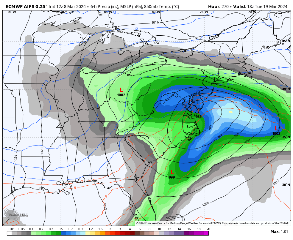
22 hours ago, psuhoffman said:
Look at this beautiful rainstorm
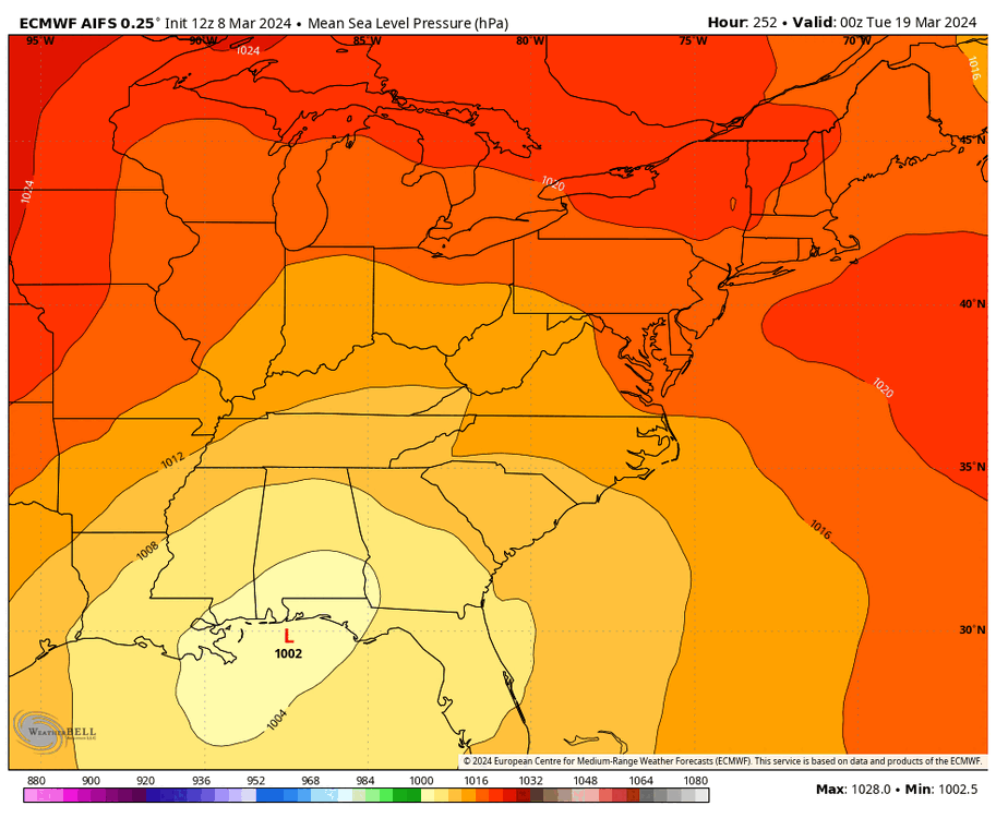

we get destroyed by heavy CCB rain! Stormy will be very happy
I think Ji would be happier with a 976 over Nagshead and a 1036 over Ogdensburg. Me? I can be happy with either as long as we have rain or snow on the 19th, after all, my region has had a dry February and early March. We have been dry slotted again today.
-
.15" yesterday. As usual, I-95 to the coast won the sweepstakes. Deltaville reports 2.09"
-
3
-
-
18 hours ago, psuhoffman said:
Are you questioning his legitimacy as a meteorologist?
Absolutely not! I have confidence that the screening is adequate to eliminate counterfeit red taggers. Supposed was a poor choice of words.
I am very surprised that someone with his obvious knowledge would seriously suggest on March 4 that "its over" except 3000' +. We are at least a month away from making that statement, even at 2000'.
March Discobs 2024
in Mid Atlantic
Posted
March has been very dry across the Central Valley. I have received a total of 1.38" compared to a normal on March 21 of 2.31". This is only 60% of normal rainfall.
This reality has resulted in a rash of wildfires aggravated by high winds.