

stormy
-
Posts
1,012 -
Joined
-
Last visited
Content Type
Profiles
Blogs
Forums
American Weather
Media Demo
Store
Gallery
Posts posted by stormy
-
-
18 hours ago, clskinsfan said:
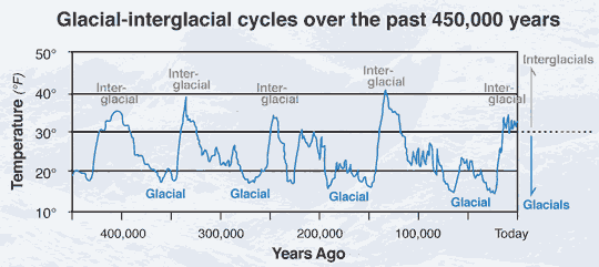
We arent even in the middle of the current interglacial yet. The planet will get way warmer before it happens. Although maybe we have sped it up.
I will be brief with an answer before deferring to the C.C. Thread.
You obviously misunderstand the premise.
This study suggests that the Glacial-interglacial cycles are not germane anymore because of our CO2 transgressions.
The climate gurus at the U.N. said 5 years ago that it would be more than 300 years before the AMOC shuts down. Now, many scientists are saying with the AMOC at its weakest in 1,600 years, it could shut down completely between 2025 and 2095.
-
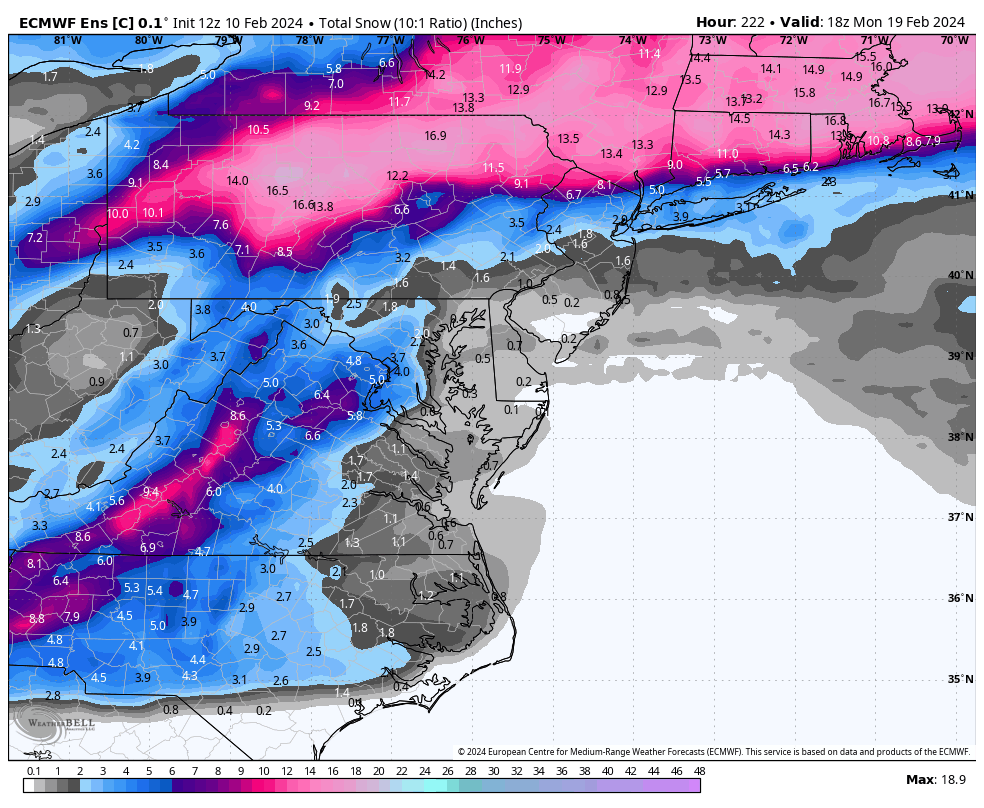
The ens. control is a little more bullish than the op. for PD.

-
 2
2
-
-
GEFS a little more generous with rain thru Tuesday than op.. 1.40 vs. 1.00"
JB will enjoy his 8 inches of snow.
-
12z op. Euro is a PD hit for the Central Valley with 6 - 7 inches of snow.
90% probability it will be gone at 00z, but nice to see.
-
GEFS is suppression city with PD, Weeklies give some possibility of northward translation.
Both GEFS and Weeklies give a reasonable threat for 23 & 24.
-
9 minutes ago, Maestrobjwa said:
Yeeeah sorting this out might take a bit...we won't know anything about this until...next Thursday
 By then we'll either be preparing to by PD3 stuff or trying to track the PSU storm!
It will all sort out and settle down by about March 20.
-
 1
1
-
-
13 hours ago, WinterWxLuvr said:
How ya feeling now?
It's a mixed bag beyond the range of the ECM and GEM. The 06Z GFS is a huge winner giving me 19 inches!!!!!!!
-
2 hours ago, psuhoffman said:
@stormybe careful of that gfs storm. It’s alone. And frankly I’m not even rooting for it because it gets to that solution because it never develops the nao block and swings a NS wave over is which opens the door to that stj wave to come north. But it’s a weird convoluted evolution with high bust potential and if that general progression is correct that’s our only shot as it totally breaks down the pattern after. No thanks. Give me the all other guidance solution. Maybe it means no PD storm but it leads to a long extends window of opportunity not just a low probability one off.
I hear ya! The 240 big 3 were close in the NW Gulf at 12z and the extended GFS op produced with support from the GEFS.
The 18 GFS has went to crap in the OV.
The Weeklies still look good Feb 21 - Mar. 20 and the potentially suppressive block has diminished.
-
5 minutes ago, Steve25 said:
Am I wrong to think that COULD be an okay thing, in terms of making the chance of cold/dry/suppressed less of a possibility?
You could be in the dough with that bet.
-
2 minutes ago, midatlanticweather said:
You made a classic blunder. The first and most important is to never start a land war in Asia. The second, somewhat less know but equally as important, is never trust weather models showing snow in the Mid Atlantic until you see it on radar at your doorstep or out your window.
Yea man! I have even seen radar fail because the scan is about 12,000 ft. over Augusta. Radar has indicated snow for hours that all evaporated before reaching the surface. That virga can be a beast out here!
-
 1
1
-
-
I'll take this at 270. 3 consecutive runs. At 240 the GFS, ECM and GEM all have the goods brewing in the NW Gulf and S. Texas. It's a SLAM DUNK with all 3 on board at 240. Rather unusual.

-
1
-
-
15.7 degrees this morning. Thats 10 degrees colder than normal!!
Regarding the lack of snow at Blackwater Falls, I remember visiting the summit of Spruce Knob at 4862 ft. during the winter back during the early 70's. It was 8 below zero at the summit at mid afternoon. There was not a trace of snow anywhere!! That was 50 years ago. It sometimes happens that way.
-
7 minutes ago, psuhoffman said:
Adding on to my general thoughts from earlier. If you add up the variables. A very slow mjo progression. The timing of the soi tanking. The block coupling with another SPV weakening. I don’t think the pattern flips again. I think we simply run the table here and winter just slowly fades later in March or April as it just gets too warm barring an extreme event eventually. Yes there will be fluctuations within that period but I don’t think we we another overall hostile long wave period this cold season.
That said if we do the timing of possible waves and project that we have at least until March 10 before climo starts to become a big problem, starting with Feb 14 we should have at a minimum 5 waves to track and maybe as many as 7. Each of these waves will have a chance as they eject from the west. Maybe some cut. Maybe some are suppressed. The lead wave could have temp issues. But it would take monumental bad luck to strike out on every one of these! And I’m being very conservative here. If we extend the window to perhaps March 15 or even March 20 given the right pattern, it could be as many as 8-10 waves with a chance. No we won’t hit them all. We won’t even hit most. But damn it we just need one big flush hit. Throw in maybe one or two other lesser events and we walk off into the sunset as the credits roll.
The big difference between now and 50 years ago is that 50 years we didn't have a clue to what your saying. Nobody did. We only knew that sometimes in winter it snowed and sometimes a lot.
Other times, folks generally said, hey! we're lucky to have an easy winter this year.
-
18z GFS pulls much more cold air upstairs at 850mb into the system on Monday. Makes a big difference.
-
5 minutes ago, CAPE said:
That's a lot of cold HP lol

Weaken that HP a little
-
5 minutes ago, Kevin Reilly said:
Yea its great thermals are all messed up though.
925 is marginal upfront, 850 will work for most.
-
3 hours ago, Ji said:
i think the Feb 13-14 storm has disappeared
Look again on the 18z GFS
-
13/14 comes to life on 18z GFS
-
2
-
-
18 minutes ago, Wonderdog said:
What's coming up next year?
The CPC believes we will be close to -.75 C. come October.
-
2 hours ago, CAPE said:
What's probably coming next winter is a Nina. There are variations, just like there are with Ninos. They don't all suck for snow, but a lot of folks in the MA seem to believe that is the case.
Exactly right, Nina's don't all suck for snow. 21-22 was a -1.0 Nina. I received 29 inches of snow.
-
1
-
-
20 minutes ago, Ji said:
If we just get to climo..winter is a disaster43% of Nino winters since 1980 have given me below normal snowfall.
I would be happy to reach climo considering that stat..
-
Saturday afternoon I predicted that southern suppression would probably be a problem going forward through February because of NS strength. Other factors can also contribute to a generally dryer than normal precipitation pattern. This morning the EPS, CMC and GEFS all support that idea through PD.
Always remember, we can sometimes have significant snow with below normal precipitation.
-
What keeps me awake at night????
February - March 1 will witness several threats but southward suppression will disappoint many.
I fear the NS will be too strong. I hope I'm wrong but I must be honest.
-
8 minutes ago, NorthArlington101 said:
Is that our HECS?Do you really believe that?? Ji is being Ji.............................
Mid/Late February will be rocking. (This year we mean it!) February long range discussion.
in Mid Atlantic
Posted
Foolishness will have to be taken up with the scientists who conducted this study because they are saying that an abrupt interruption of natural cycles very similar to the Younger Dryas may be coming soon. It could have devastating impact around the world.
When you say that the level of impact that humans can have on the climate is limited, I believe You and I could be friends.
Enjoy the Super Bowl.