

stormy
-
Posts
1,012 -
Joined
-
Last visited
Content Type
Profiles
Blogs
Forums
American Weather
Media Demo
Store
Gallery
Posts posted by stormy
-
-
7 hours ago, rjvanals said:
The crazy thing is the Mid-Atlantic forum is doing better relative to average compared to pretty much anywhere on the east coast (Syracuse and Erie with under 30 inches so far this year is crazy). It's been a failure for the entire east coast not just us.
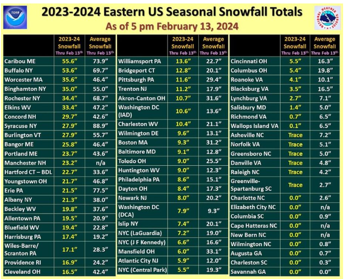
Statistics are always fascinating to me. The very interesting thing here is that Caribou,Maine has only received 75% of normal snowfall while DCA has received 85%!!!
There is much more at issue here than simply being too warm.
Thanks for posting this very revealing information!!
-
GFS much better than NAM
-
2 minutes ago, psuhoffman said:
The 1960's were a -PDO, 2017-2019 were a positive PDO, the PDO alone is not an excuse for what is happening recently.
Psu, you are a smart man. Regarding, "what is happening recently". Tell me, what is your solution to "what is happening"........................ What should we do????? I am very serious...........
-
1 minute ago, Eskimo Joe said:
Let's see if we can add 0.25" QPF regionwide and drop temps by 2 to 4 degrees.
Don't be greedy!!!!!!
-
The 18z GFS has trended south.
-
The 18z NAM has an ESE trajectory from N Kentucky with cold air filtering in from the NW. This could work for a 1-3 swat. 850 looks fine.
-
17 minutes ago, Maestrobjwa said:
Babar?
Babar the elephant
-
1 hour ago, AlexD1990 said:
Can the Gulf Stream hurry up and collapse? I want snow.

If that happens during your lifetime you may be very disappointed!
-
7 minutes ago, baltosquid said:
Dry slot on 01z HRRR messes up the transition period, doubt something like that is going to get modeled just as it really ends up but something to watch. If the best opportunity for column cooling rates gets wasted by a dry slot, many will end up with little to nothing.
The Valley dry slot filled in from 00 - 01 and shifted east to Charlottesville.
-
8 minutes ago, WinterWxLuvr said:
The main difference from earlier is precip amounts, which truthfully are probably very difficult to nail down. People talk about warm ground and yes we had a couple of warm days but we also had about 3-4 straight days last week in the upper teens.
It is a trend. If you see qp amounts drop run after run on the HRRR that is not good. A 1 run fluke is no big deal but run after run is a big deal most of the time.
-
The NAM drops Winchester from 4.5 - 1.3.
The HRRR dry slot I pointed out a little while ago is all over the NAM. Qp drops 50% 20 mi south of D.C.
-
The 00z HRRR is now dry slotting the Valley up to New Market. QP has dropped 1.00" in 4 hrs..
-
16 minutes ago, WesternFringe said:
Is it telling that it’s 46° in Staunton and is snowing and raining at the same time right now?
I just left Staunton and only had a few sprinkles.
-
My forecast: DC 1-2", Baltimore 3", Winchester 2", Hogback at 3,500' 6"........................
-
5 minutes ago, snowmagnet said:
I’m wondering why the NWS hasn’t posted at least a Hazardous Outlook for the counties surrounding DC N and W since this could impact rush hour.
That should be very telling to you.
-
58 minutes ago, high risk said:
Goddamnit, y'all. I have literally worked as a RAP/HRRR developer, and I would still use the JMA or NAVGEM before I used the RAP/HRRR system for snow amounts.
")
These people have a fever for high snow amounts.
-
15 minutes ago, Terpeast said:
At this rate, this will be a EZF-RIC hit

(half joking)
This morning I told Ji Short Pump
-
42 minutes ago, NorthArlington101 said:
RAP stands for Really Always Perfect model... right?

8 inches in Harrisonburg LOL
-
11 minutes ago, stormtracker said:
This is definitely a low point and things look kinda bleak tbh. But I urge everyone to hang in there until at least this weekend or even Monday 0z. Models are all over the place. If the pattern is looking like shit or we're not tracking by then, I dunno man
Keep the faith, March will be rockin!
-
3 minutes ago, stormy said:
The 12z NAM has warmed. Went from 35 - 37 at 10am Tuesday up to 44 by 1 pm.
3k NAM is about 5 degrees colder
-
The 12z NAM has warmed. Went from 35 - 37 at 10am Tuesday up to 44 by 1 pm.
-
 1
1
-
-
9 minutes ago, SnowenOutThere said:
Noticing the use of past tense here, are you close to saying its more or less over besides the 18th-22nd time period?
Its never over for significant snow until at least March 15, especially this year.
-
5 hours ago, Ji said:
How much further south can this go?
Sent from my SM-A515U using Tapatalk
Short Pump
-
2 minutes ago, SnowenOutThere said:
Blud thinks he assembling a team

Its already 2 - 1
The Weekend Rule? Saturday 2/17 - The Icon Storm
in Mid Atlantic
Posted
My latest 3 model blend for DC is 1.9 inches, Kuchera, GFS ECM GEM.
West of the BR, Staunton to New Market is 3.1".