stormy
-
Posts
1,023 -
Joined
-
Last visited
Content Type
Profiles
Blogs
Forums
American Weather
Media Demo
Store
Gallery
Posts posted by stormy
-
-
7 minutes ago, clueless said:
My question as well. Do we go past the first week of March? Crystal ball, anyone?
I don't believe "we go past the first week of March" but we could be in the last week of February to first week of March before significant pay-dirt.
-
I Love those classic cars buried in snow during early March of 1960............................................. https://winstonsalemtimetraveler.com/2020/03/18/wayback-wednesday-the-snowy-march-1960-wednesdays/
-
 2
2
-
-
11 minutes ago, WVclimo said:
Thanks!! I was just ready to try again with the link.
-
A lot of high anticipation is quite obvious this afternoon. Will mid February to mid March thrill snow lovers in the tristate region or will it end in disappointment????
We cannot know at this time. Ask me around April 1.
Psu has often referred to 1958 Feb/March. The advertised possibilities are now reminding me of 1960. During mid Feb - mid March of 1960, brutal cold and repetitive snowstorms nearly paralyzed the western Carolina's and Virginia.
While your dreaming about the possibilities, read the details of 1960 from Laurence Lee of NOAA: file:///C:/Users/James/Downloads/Review_Feb-Mar_1960(1).pdf
-
1 hour ago, IronTy said:
I've only been down here in Maryland for 19yrs, so 09-10 I had been here for five years. I wish I knew then what I know now - I sort of just figured those types of monster storms were not common, but relatively regular. Knowing what I know now I think I would have taken a lot more time off work to enjoy it and play in the snow to savor how awesome that winter was. If I was still in my 20s maybe I'd more to Alta, UT to live in the snow. Now in my 40s that seems a little too much, but man, life regrets.
I'm with you man!! We all have regrets looking back over our lives.
-
29 minutes ago, psuhoffman said:
@Terpeast I’m not sure the lack of an HECS after PD isn’t partly just small ample size. Baltimore has only had 9 20” storms in 130+ years of records. One of those did happen in late March! They’ve had several 10” plus storms after Feb 20. I’m not sure with a sample of 9 in 130 years we can say that the odds really collapse that much between Feb 20-March 10. Obviously they do degrade some and after mid March there is a cliff at some point. But given the right pattern I don’t think a 20” storm late Feb or early March is that much less likely.
Thinking back on my lifetime the bigger issue is there often has not been the right pattern between Feb 20-March 10 for that kind of storm. We’ve had some great looks mid and late March when I do think it was getting difficult for DC and Baltimore to cash in big. But Feb 20-March 10 has kinda been a weird dead zone many years. Plenty of “good” patterns but not really many I can remember thinking an hecs was likely or even possible.
You just haven't lived quite long enough!
-
17 minutes ago, Shad said:
is there any hope that cold air improves as this gets closer......seems like a true CAD type event. Ice a possibility here?
Ice is trending in your direction. Perhaps a half inch of ice in southwest Va.
-
21 minutes ago, Shad said:
If the Feb 5 event does end up coming North to much of the mid atlantic are temps not going to be an issue??....seems as we are either going to get moisture with warmer air or dry and cold.....typical I guess? Does this have a shot at being a Mid Atlantic snow event for VA, MD
If the GFS 24 hr. trend continues the 12z run will have precipitation up into central Virginia. Surface and 850 temps. would be borderline.
-
7 minutes ago, Bob Chill said:
Next 10 days looks like a variation of Dec with the central/eastern Canada blocking ridge. I never want to see one again lol. H5 mean plots in the rear view will look "good". PSU illustrated that earlier this month. But ground truth is anything but.
We don't see that type of setup much and I learned something.... It will prob never be cold enough for snow when the streams stay separate in this regime. When they do, they keep the warm and cold air all neat and bottled up away from each other with no mechanism to mix. . So it requires a phase of sorts to pull down workable air. But phasing also curls storms and a big flat Canadian ridge really isn't a block as much as a guardrail. So the phase requirement introduces significant storm track risk. Idk man. The longwave pattern has been hostile for east coast snow door to door so far except for fits and spurts. Sometimes it's just how it goes and not some big lesson or evidence of trouble in years to come. That's where my head is. I don't see this year as some big scary piece of evidence to fear the future. We get a lot of rain and warmth on the winter. The early 80s were terrible for that stuff. I mean TERRIBLE. This winter has reminded me of those stinker periods.
Thanks Bob for your usual bundle of wisdom.
-
 1
1
-
-
18 minutes ago, Terpeast said:
And I don’t see any potential for wintry weather until VDay and beyond. My target was Feb 10-12 a week or so ago, and this is the first sign of a can kick, even if its by just a few days. Clock is ticking. Think I was right to revise my snowfall forecast. Another minor/moderate event might get us to the low end of my forecast. Otherwise it will be a bust. Hope I’m wrong, but things seem to be trending that way.
Honestly, I had this feeling 24 hrs. ago. after I looked at the latest Weeklies.
I tracked the trajectory of the lowest heights and got an uneasy feeling. I still have high hopes but not as confident as 5 days ago.
-
10 hours ago, clskinsfan said:
I dont even see his posts. He has been on ignore for weeks. He adds absolutely nothing of value to this board. Nothing.
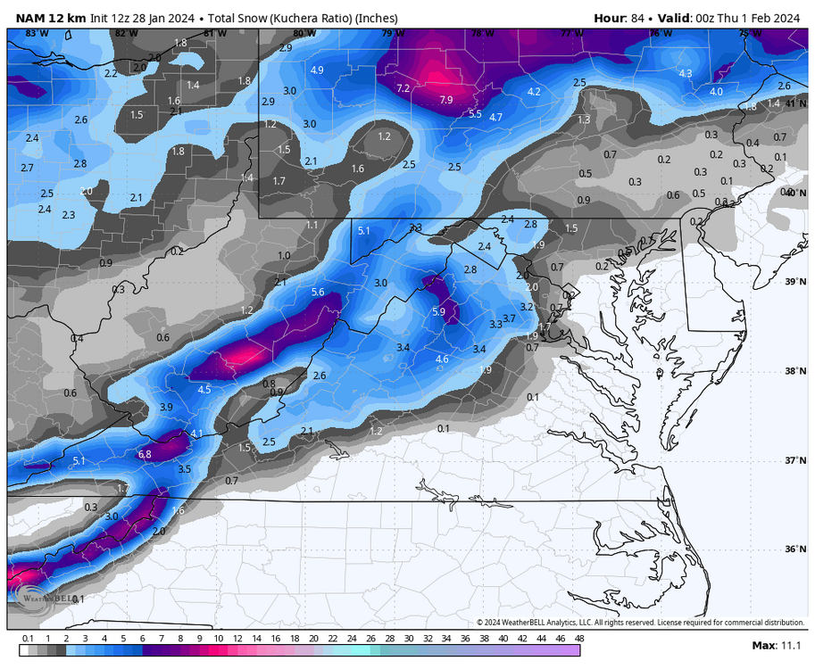
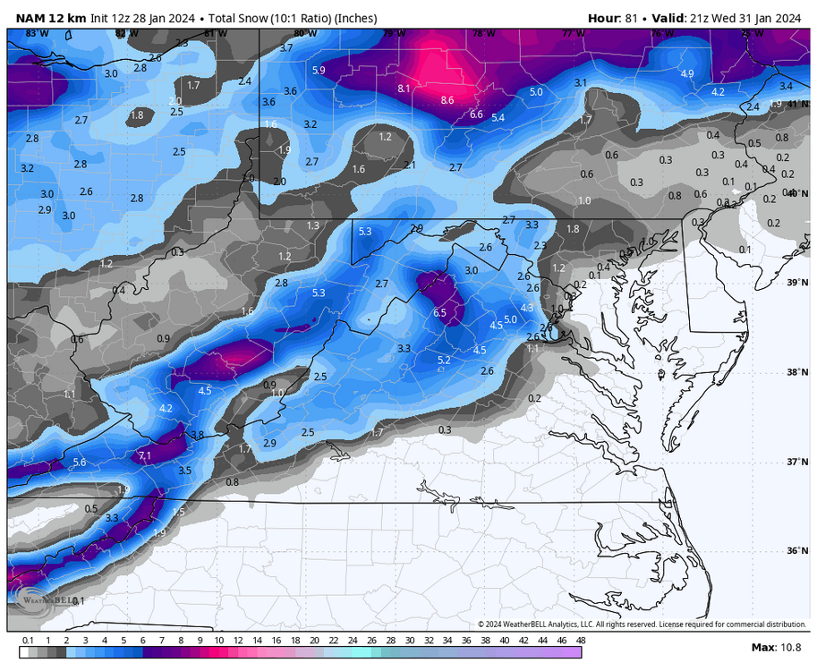
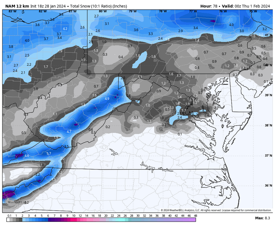
You say that you ignore me because I don't make contributions. A lot of posters don't really make contributions. Do you believe that making blatantly incorrect posts is making a contribution?? You said the 18z NAM " was " better this run". Considering the significant down grade on WB I find it unlikely that Pivotol was better unless you want less snow!! Anyone can make a mistake, I believe you made one and don't have the courage to admit it. All you can do is attack others. That is very disappointing.
-
 1
1
-
-
-
-
This potential will affect areas along and west of the Blue Ridge, focusing on the central and southern Valley and western highlands.
Tuesday night: Mostly cloudy with a 60% likelihood of snow showers after midnight. Lows of 31 - 33
Wednesday: Early snow showers tapering off, remaining mostly cloudy with highs of 35 - 40.
Accumulations of a dusting to 1 inch below 2000 ft. elevation.
Accumulations of 1 -3 inches, 2500 - 4500 ft. elevation.
-
1 hour ago, CAPE said:
Not gonna lie, I really want the 5-6th window to work out. Been tracking it for ages it seems, and it is still almost 10 days away lol. How great would it be to get a moderate event leading into what looks like the period with the most upside this winter.
Good Luck Cape! The 18z GFS says southern suppression but there is a plenty of time!
-
-
-
The Euro just won't give up on 2-5 !!!!!!! 7 inches at Norfolk .......... On to 00z.
-
13 minutes ago, stormtracker said:
No sensible change for us, but the look is way different vs 0z. Didn't see 6z. Let's see how this changes things downstream
This is beyond 6z. The Euro is interested.
-
 1
1
-
-
45 minutes ago, NorthArlington101 said:
Are we ignoring the GFS/CMC/EURO all having a clipper push through on Wednesday? Doesn’t look super exciting but favored spots get T-2” out of it. Only 5 days out
The 12z GFS and now on board GEM gives Augusta 1.5 - 3.0 inches from this system at 96 - 120
Upstairs temps. look good but likely an elevation event unless we chill a few degrees.
-
-
45 minutes ago, Weather Will said:
Things are looking a lot better, but parts of the Valley are still abnormally dry. My water table is still 10.68 ft. below normal according to the USGS.
-
 1
1
-
 1
1
-
-
47 minutes ago, snowmagnet said:
That explains DT's Pamela Anderson pattern. LOL
DT's PA Pattern died with the issuance of the 00z GFS.
-
14 hours ago, stormy said:
Are we seeing something here that should not be happening??
This was my post late yesterday after being surprised by the 18z GFS op for a few minutes. I then realized with these words that the 18z was likely trash that would not stand the test of time. I didn't call it trash at the time for obvious reasons considering the euphoria. 240+ hours is almost always fantasy land for the GFS op.
The EPS still looks fine for Feb. 12 - March 12.


Mid/Late February will be rocking. (This year we mean it!) February long range discussion.
in Mid Atlantic
Posted
That's usually about once every 3 or 4 years and mostly in December.