

stormy
-
Posts
1,030 -
Joined
-
Last visited
Content Type
Profiles
Blogs
Forums
American Weather
Media Demo
Store
Gallery
Posts posted by stormy
-
-
This morning it is basically GFS/ICON vs. ECM/GEM . What is your preference?
-
 3
3
-
 3
3
-
-
The blue shrinks on the 06 EPS
-
4
-
-
43 minutes ago, LeesburgWx said:
Looks like we may be reeling this one in. Euro looks like GFS now with snow amounts. I’ll be damned. Those ensembles look beautiful too
You better look again
-
We're on an 18z GFS high right now................. Where will we be at 6 am if Dr. No persists???
-
 1
1
-
-
At 15z Tuesday the GFS places the LP inside of Hatteras. That is very important for inland areas!
The EURO will cave at 00Z IMAO........................
-
 1
1
-
-
GFS STANDS PAT..........................
-
At this point the deck is stacked against the Op. Euro.
It is an outlier without a friend. The EPS, GFS and GGEM all say yes and it is Dr. NO
If the 18z GFS stands pat, I believe the 00z Euro will come back into the fold.
If the 18z GFS collapses , well....... better luck next time.
Remember, the models are smarter than we are. Wouldn't it be nice if they gave a 3 paragraph reasoning explanation of every run?
-
1
-
-
8 minutes ago, Ji said:
this would never happen with a cutter/Rainstorm
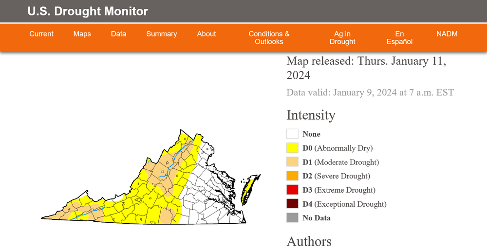
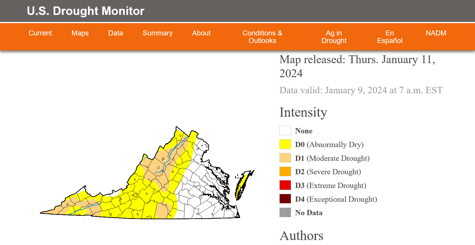
It's been happening all last summer. That's why we're still in a moderate drought in the Valley.
I'm not saying that! The U.S. Drought Monitor is...........................
-
About noon yesterday when I said in this thread that "I would rather place this lp near Myrtle Beach than 275 se of NYC", I of course had no idea that future runs of the Euro would come close to that desire. I only knew from historical observation that a coastal hugger from Charleston to Norfolk with cold air in place usually does the trick for inland areas.
January 29 of 1966 witnessed the coldest major snowstorm of my life. At 4 pm in Augusta County I recorded whiteout conditions with a temperature of +4. The lp at 6 pm was near New Bern in southeast N.C..
Tuesday's threat as currently modeled should make many happy with a light to moderate several inches of snow. Changes can and will occur at 5 days out. The Euro could fringe inland area's with lp 50 - 100 miles off the N.C. coast. The GFS would only give flurries with no organization but a frisky sw and incoming trough over western Va. enhances snowfall.
The next few days should be very interesting!
-
1
-
-
4 minutes ago, Yeoman said:
Looks like we'll need a travelers advisory for Short Pump
Make that a Hazardous Driving Warning
-
2 hours ago, brooklynwx99 said:
the 12z ECMWF has a coastal storm
Thanks for your correction!
Closer scrutiny would have said the 12z ECM is OTS as modeled regarding significant Va. impact but does give significant snowfall up the coast from Delaware to Boston with the center well offshore. The GFS follows a similar track but flounders around in the Atlantic until consolidating about 200 miles east of Cape Cod on Wed. morning.
-
1
-
-
Though the GFS has trended toward the ECM off the SC coast, the pattern is too progressive and its still OTS like the 12z ECM.
-
The Big Three are all trending in the right direction.
This is not the final solution but a definite sw shift with action by the current leader. My wish in this thread 2 hours ago about Myrtle Beach instead of 275 se NYC seems to be in the cards.
-
Just now, LeesburgWx said:
What is the give up date for snow this year?
April 10
-
1
-
1
-
-
I believe the 12z GFS is a step in the right direction. To be simple, more flakes over us. Dear God! No need to be so negative, this is 6 days away. Sure, at 06z next Tuesday I would rather place that developing lp over Myrtle Beach instead of 275 m se of NYC. Give it time and hope for the best.
-
1
-
-
1 hour ago, Terpeast said:
1994 and 1988 I can see why we got screwed (50/50 ridging).
But that Feb 1977? By all rights we should have gotten buried up to the second floor of our houses. 50/50? Check. NAO? Check. Western ridge? Check. Aleutian low? Check. And yet we got almost nothing.
I'm happy to learn that we "got almost nothing" from a professional meteorologist 47 years ago back in Feb of 1977 when we should have "gotton buried up to the second floor of our houses". Some on this board seem to believe that severe snow droughts have only occurred in recent years.
76-77 was very cold with the up-slope mts. to our west getting buried while we often came up frigid and DRY.
-
2
-
-
15 hours ago, clskinsfan said:
Thats wild. It is calm as can be out here west of the Blue Ridge.
The models predicted minimal winds west of the BR on Monday.
-
3 minutes ago, pazzo83 said:
lol what
The US Geological Survey at 3:15 pm gives the following data for the D.C. Little Falls Pump Station on the Potomac. Gage height 3.90 Ft. 24 hrs. ago gage height 3.55' . Up about 5 inches.
Downstream from DC runoff I would guesstimate a 1 ft. increase. But strong s and se winds are producing a backswell rise from the bay. High tide at Alexandria is coming at 6 pm. This exacerbates the problem.
-
1 minute ago, jacindc said:
NBC 4 showing the Potomac over its banks in Alexandria.
I seriously doubt this.
-
1
-
-
2.00" at 4 pm. 39 degrees at 4:30.
-
27 minutes ago, Jrlg1181 said:
Already up to 1.15 inches of rain this morning ...
I'm dry at only .92"
-
6 minutes ago, Ralph Wiggum said:
Wasn't a bad run. I don't think anyone is expecting a huge hit or this to trend into anything too intense with the 15th-16th thing. Maybe I'm wrong but I think the upside is somewhat capped with this one. However, I'm certain many would be OK with a ground whitener followed by BN cold.
My lifelong fascination with the weather and 60 years of observations tell me that Jan. 15 - Mar. 15 will produce. This winter is removed from recent crap. Just please be patient and give it a chance.
-
4
-
-
GFS just can't jel with the front on Monday. Tomorrow will be better.
-
5 minutes ago, CAPE said:
Founders CBS. A tad bit more substantial.
")
At 5.9 % I can enjoy with a little buzz. 11.7% would put me on a psychedelic spin.
-
2
-
Jan Medium/Long Range Disco 2: Total Obliteration is Coming
in Mid Atlantic
Posted
The CMC ens is OK. The GEM op is lacking blue over D.C./ Augusta