

BuffaloWeather
-
Posts
25,688 -
Joined
-
Last visited
Content Type
Profiles
Blogs
Forums
American Weather
Media Demo
Store
Gallery
Everything posted by BuffaloWeather
-

Historic Christmas Lake Effect Blizzard
BuffaloWeather replied to BuffaloWeather's topic in Upstate New York/Pennsylvania
If you're looking for the snowiest city in Erie county with modern conveniences that would 100% be Springville. It's about a 40-45 minute drive from the city of Buffalo. They average around 200" per year. If you're looking for the secondary snowbelt only 25-30 minutes away from the city that would be Colden/Boston Hills area. Where I live in Hamburg is the immediate southtowns where I can walk to everything I need and still average 110-120" per. I can drive to downtown Buffalo in 15 minutes and I can get to the lake in 5 minutes. Which I love in the summer as the sun sets in the west over lake Erie. The sunsets here in the summer are incredible. The farther away you get from the lake the better snow retention as the elevation increases pretty quickly from west to east across the county. If you don't want a lot of snow you want to move north of Buffalo, some the averages up there are 70-80" per year. The taxes are pretty high in every suburb. The farther you go out from the city the lower the taxes on average. If you want to go for maximum snowfall in Western New York you want to head even further south into ski country. Towns like Perrysburg, Mayville, South Dayton all average 200"+ per year but are about 45 minutes-1 hour away from the city of Buffalo. They get the best of both worlds with maximum elevation and orographic lift off the hills off of the lake. -
Historic Christmas Lake Effect Blizzard
BuffaloWeather replied to BuffaloWeather's topic in Upstate New York/Pennsylvania
-
Historic Christmas Lake Effect Blizzard
BuffaloWeather replied to BuffaloWeather's topic in Upstate New York/Pennsylvania
Are you moving here for the snow or for work? What's most important to you conveniences, land, close to the lake? -
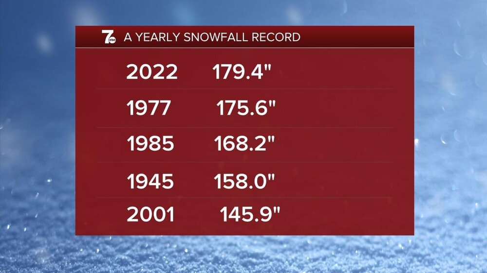
It really has, I love the snow as much as the next person but this city needs a break and we look to get that the next 10 days with the warmup. I'm up to 149" on the season and winter started 5 days ago...Another snow band is moving in as we speak thats supposed to drop 6-8" tonight. I've never seen anything like it. My town here in Hamburg averages 110-120" a year.
-
Historic Christmas Lake Effect Blizzard
BuffaloWeather replied to BuffaloWeather's topic in Upstate New York/Pennsylvania
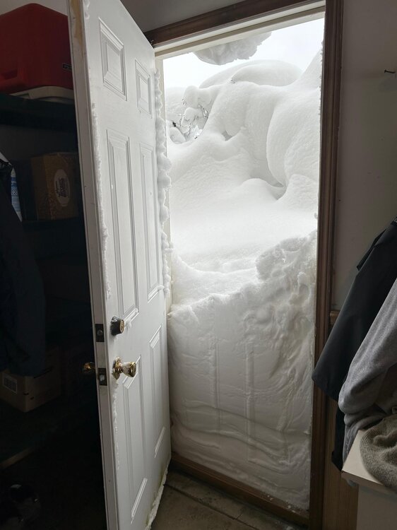
I think around 6-7". It was melting quick with the rain and warmth before the storm hit. That is solid concrete now. -
Historic Christmas Lake Effect Blizzard
BuffaloWeather replied to BuffaloWeather's topic in Upstate New York/Pennsylvania
47.6" storm total up to 149" on the year. -
-
Historic Christmas Lake Effect Blizzard
BuffaloWeather replied to BuffaloWeather's topic in Upstate New York/Pennsylvania
-
Historic Christmas Lake Effect Blizzard
BuffaloWeather replied to BuffaloWeather's topic in Upstate New York/Pennsylvania
Cheektowaga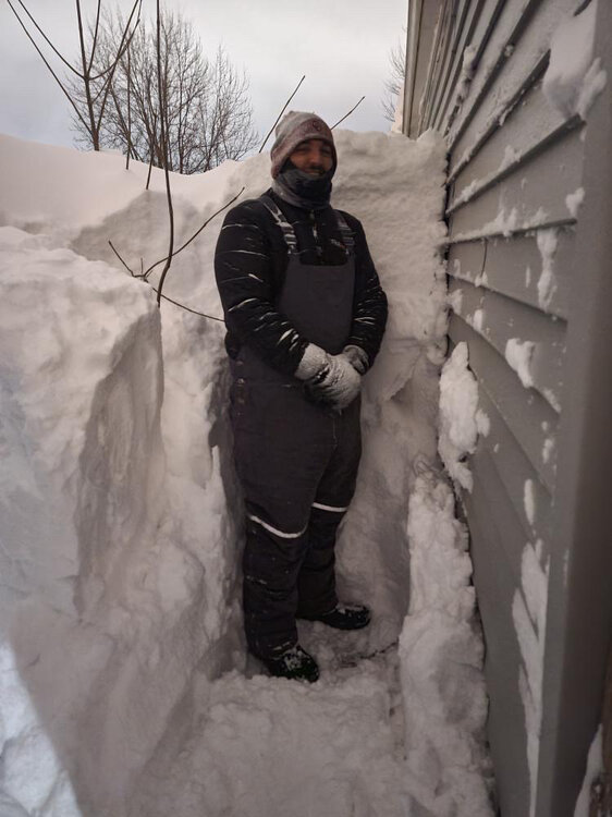
-
Historic Christmas Lake Effect Blizzard
BuffaloWeather replied to BuffaloWeather's topic in Upstate New York/Pennsylvania
14 people found outside… -
Historic Christmas Lake Effect Blizzard
BuffaloWeather replied to BuffaloWeather's topic in Upstate New York/Pennsylvania
Little more coming tonight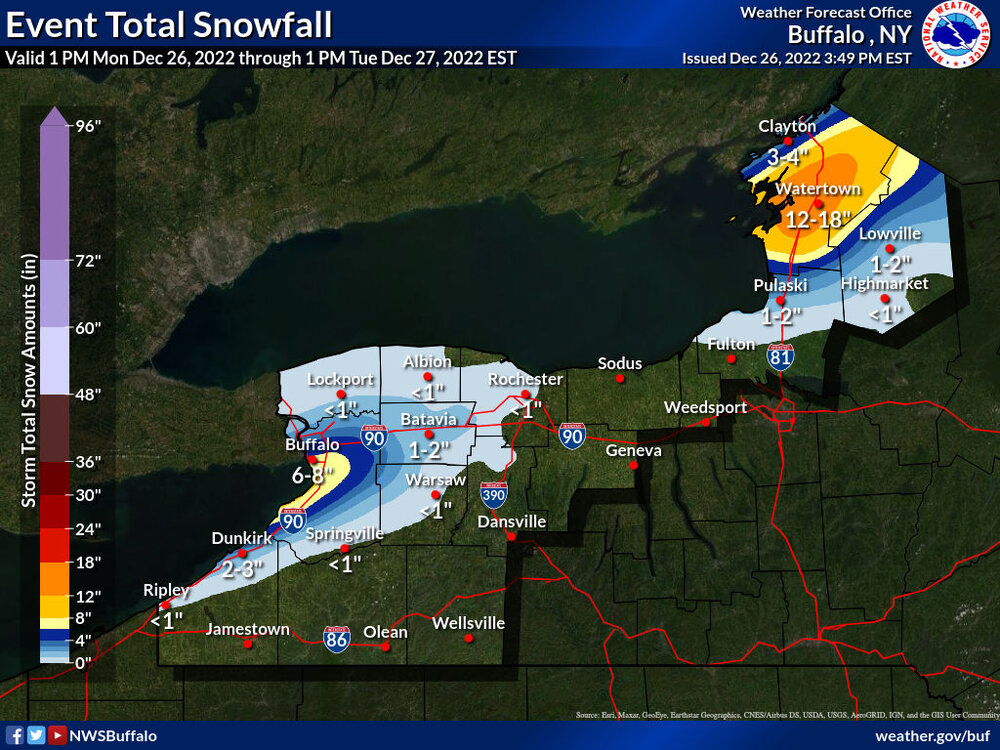
-
Historic Christmas Lake Effect Blizzard
BuffaloWeather replied to BuffaloWeather's topic in Upstate New York/Pennsylvania
-
Historic Christmas Lake Effect Blizzard
BuffaloWeather replied to BuffaloWeather's topic in Upstate New York/Pennsylvania
Death toll is up to 27 -
Historic Christmas Lake Effect Blizzard
BuffaloWeather replied to BuffaloWeather's topic in Upstate New York/Pennsylvania
-
Historic Christmas Lake Effect Blizzard
BuffaloWeather replied to BuffaloWeather's topic in Upstate New York/Pennsylvania
-
Historic Christmas Lake Effect Blizzard
BuffaloWeather replied to BuffaloWeather's topic in Upstate New York/Pennsylvania
-
Historic Christmas Lake Effect Blizzard
BuffaloWeather replied to BuffaloWeather's topic in Upstate New York/Pennsylvania
Cheektowaga - Emergency units have confirmed the total collapse of a 160 foot cell tower behind Wegmans on Dick Road. -
Historic Christmas Lake Effect Blizzard
BuffaloWeather replied to BuffaloWeather's topic in Upstate New York/Pennsylvania
heaviest part of band is back over me ...A BAND OF HEAVY SNOW WILL AFFECT PARTS OF ERIE...NORTHWESTERN WYOMING...AND WESTERN GENESEE COUNTIES... HAZARDS...A BAND OF HEAVY LAKE EFFECT SNOW WILL CONTINUE ACROSS SOUTHERN AND CENTRAL ERIE COUNTY EAST INTO SOUTHWESTERN GENESEE AND NORTHWESTERN WYOMING COUNTIES. SNOWFALL RATES UP TO 2 INCHES PER HOUR WILL CONTINUE IN THE MOST INTENSE PORTION OF THE BAND. LOCATION AND MOVEMENT...THE BAND OF HEAVY LAKE EFFECT SNOW WILL REMAIN NEARLY STATIONARY THROUGH THE EARLY OVERNIGHT HOURS, WITH MINOR NORTH SOUTH OSCILLATIONS. -
Historic Christmas Lake Effect Blizzard
BuffaloWeather replied to BuffaloWeather's topic in Upstate New York/Pennsylvania
-
Historic Christmas Lake Effect Blizzard
BuffaloWeather replied to BuffaloWeather's topic in Upstate New York/Pennsylvania
Derby is at 56" -
Historic Christmas Lake Effect Blizzard
BuffaloWeather replied to BuffaloWeather's topic in Upstate New York/Pennsylvania
I got this drift on my live stream tonight Heres the full walk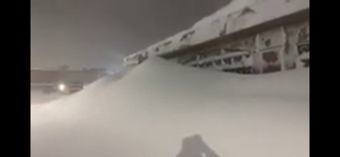
-
Historic Christmas Lake Effect Blizzard
BuffaloWeather replied to BuffaloWeather's topic in Upstate New York/Pennsylvania
Check out reeds recap. Just insane conditions during the peak. A literal snow hurricane. -
Historic Christmas Lake Effect Blizzard
BuffaloWeather replied to BuffaloWeather's topic in Upstate New York/Pennsylvania
https://www.foxweather.com/extreme-weather/buffalo-blizzard-1977-history.amp -
Historic Christmas Lake Effect Blizzard
BuffaloWeather replied to BuffaloWeather's topic in Upstate New York/Pennsylvania
46.1" storm total


