BuffaloWeather
-
Posts
25,688 -
Joined
-
Last visited
Content Type
Profiles
Blogs
Forums
American Weather
Media Demo
Store
Gallery
Everything posted by BuffaloWeather
-
 There is already a thread created for general upstate weather talk. I tried to keep it active but people highly prefer discord over it. Weather has been quite boring as well besides the big LES events that have their own separate threads.
 -
Historic Christmas Lake Effect Blizzard
BuffaloWeather replied to BuffaloWeather's topic in Upstate New York/Pennsylvania
-
Historic Christmas Lake Effect Blizzard
BuffaloWeather replied to BuffaloWeather's topic in Upstate New York/Pennsylvania
-
None. I think the blizzard conditions lasted over 40 hours straight. It will go down as the deadliest and worst storm in Buffalos history. The highest wind gust was 79 MPH, highest snow total was 53". All of Erie county got over 3 feet of snow which is quite expansive and well over a million people in total were affected. The airport was closed from Friday morning until today. The city of buffalo had a driving ban for 6 days.
-
Historic Christmas Lake Effect Blizzard
BuffaloWeather replied to BuffaloWeather's topic in Upstate New York/Pennsylvania
-
Historic Christmas Lake Effect Blizzard
BuffaloWeather replied to BuffaloWeather's topic in Upstate New York/Pennsylvania
-
Historic Christmas Lake Effect Blizzard
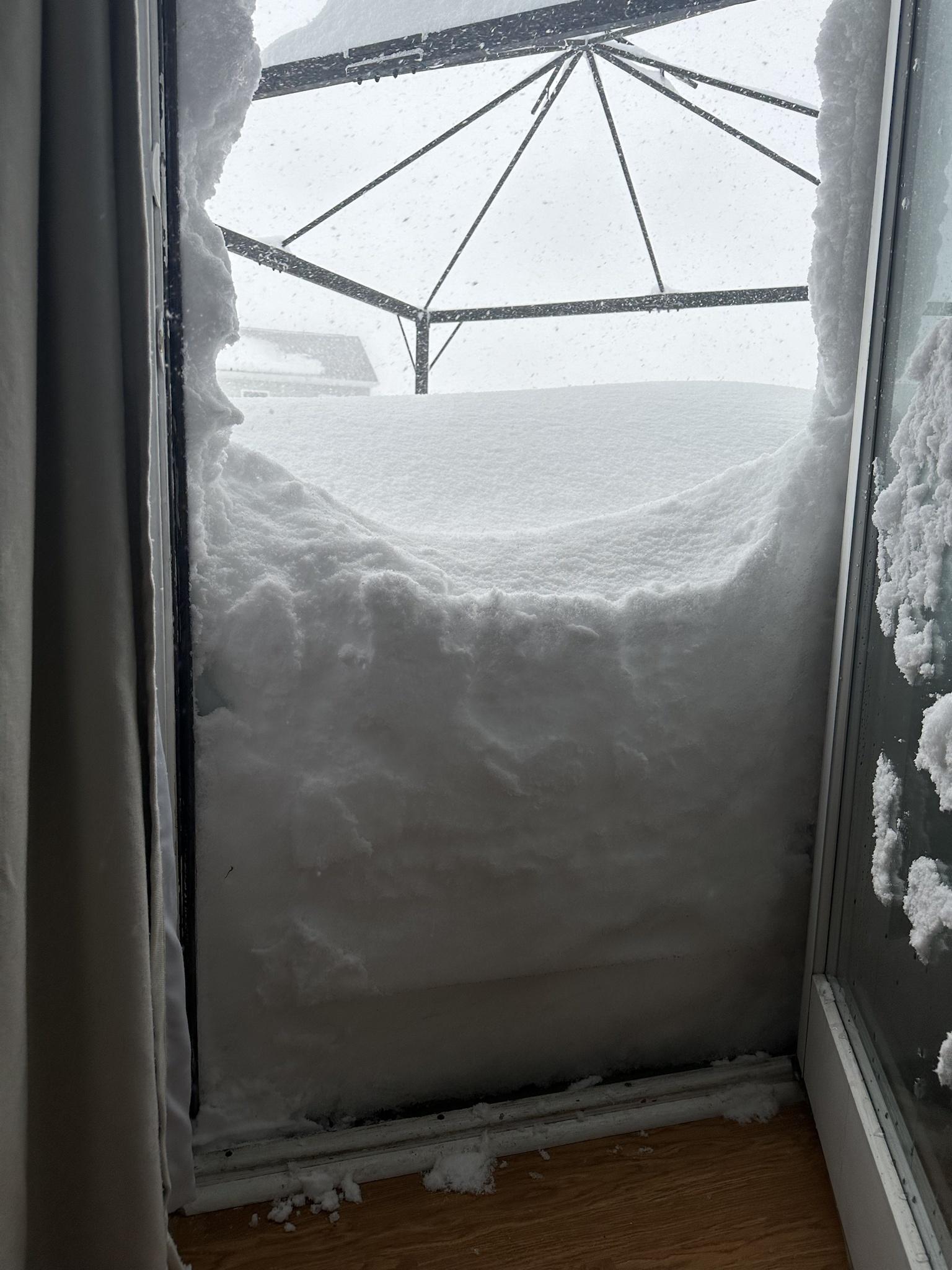
BuffaloWeather replied to BuffaloWeather's topic in Upstate New York/Pennsylvania
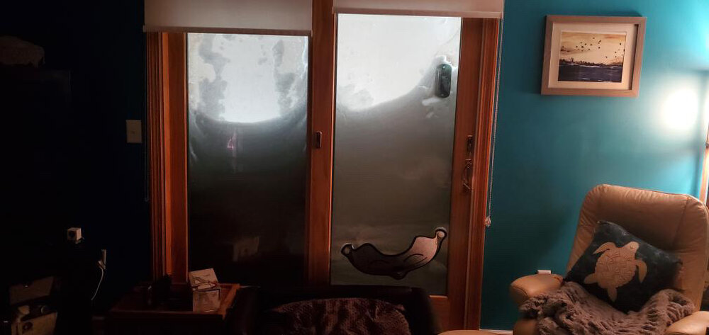
Here was my deck
-
Historic Christmas Lake Effect Blizzard
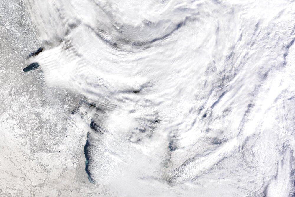
BuffaloWeather replied to BuffaloWeather's topic in Upstate New York/Pennsylvania
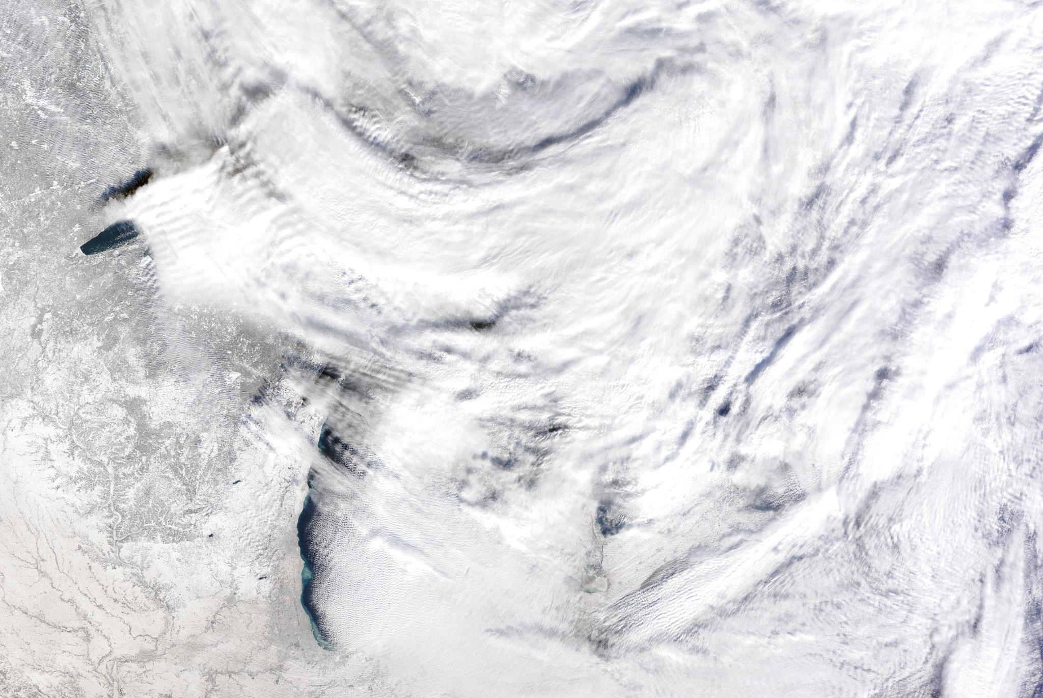
Lake Erie is still ice free, check out the silt from all the winds and the sand being brought up from the lake floor. -
Historic Christmas Lake Effect Blizzard
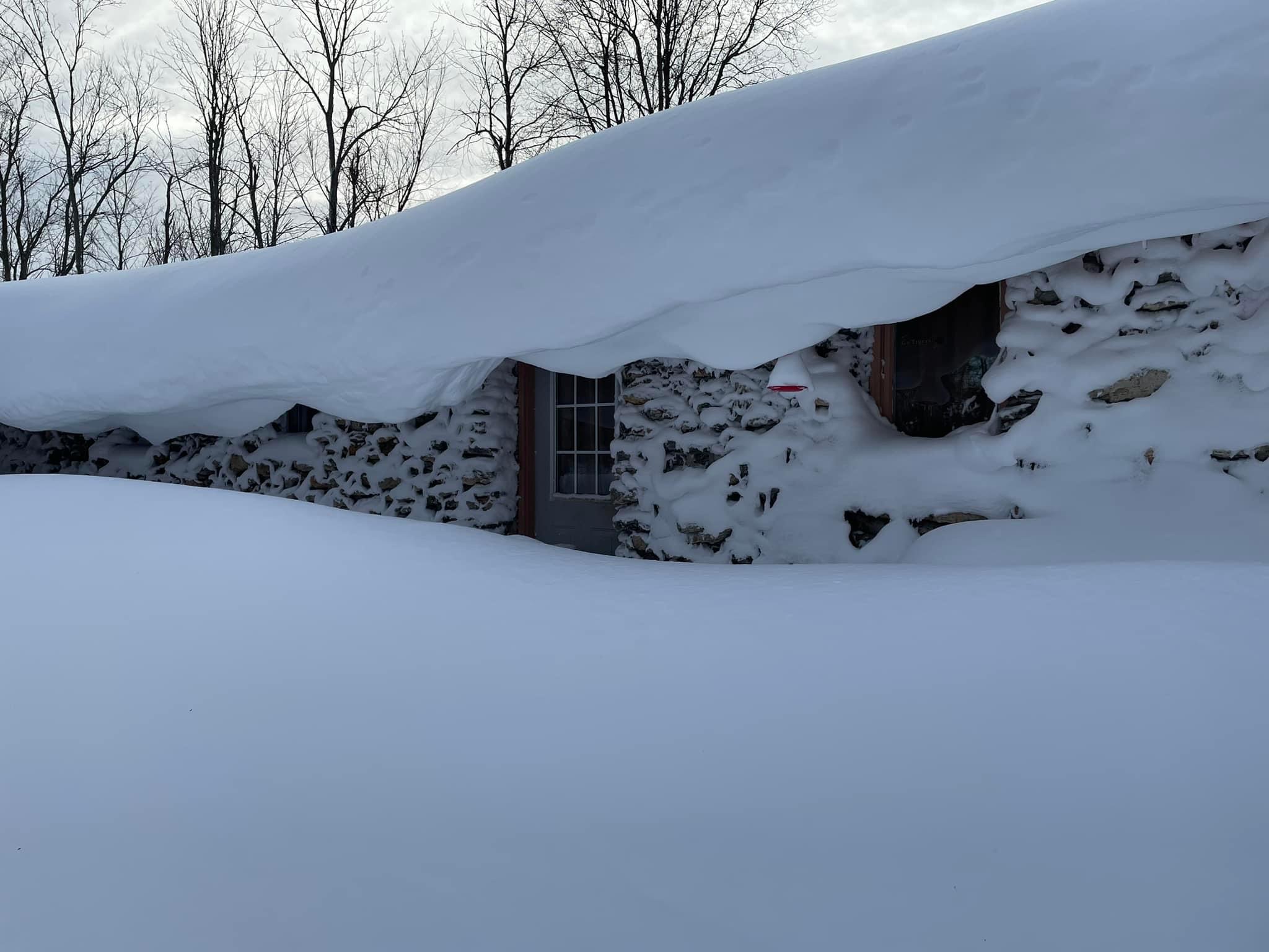
BuffaloWeather replied to BuffaloWeather's topic in Upstate New York/Pennsylvania
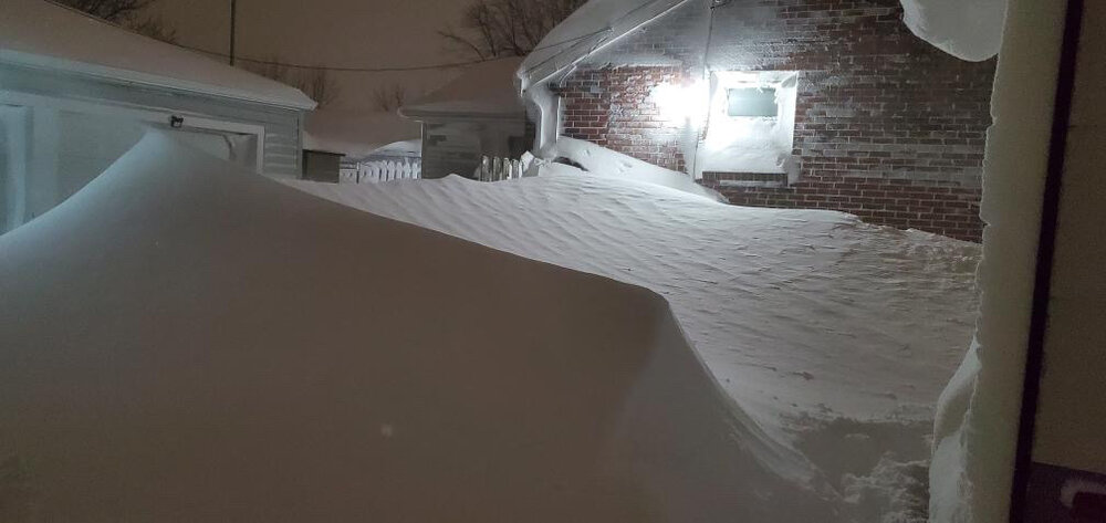
My sisters house in Cheektowaga. -
Historic Christmas Lake Effect Blizzard
BuffaloWeather replied to BuffaloWeather's topic in Upstate New York/Pennsylvania

-
Historic Christmas Lake Effect Blizzard
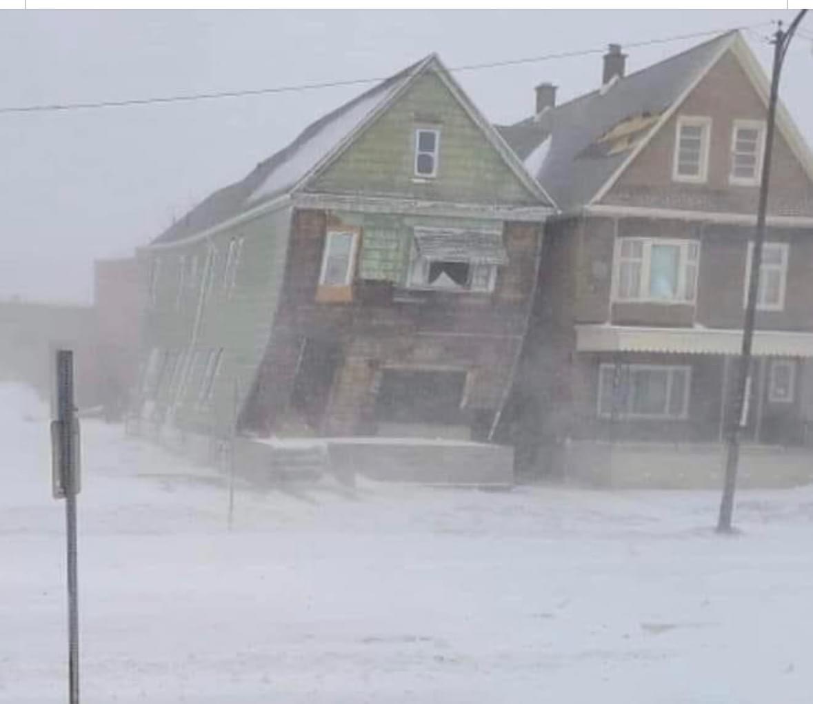
BuffaloWeather replied to BuffaloWeather's topic in Upstate New York/Pennsylvania
The wind caused this house to move off it’s foundation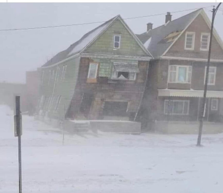
-
Historic Christmas Lake Effect Blizzard
BuffaloWeather replied to BuffaloWeather's topic in Upstate New York/Pennsylvania
-
Historic Christmas Lake Effect Blizzard
BuffaloWeather replied to BuffaloWeather's topic in Upstate New York/Pennsylvania

-
Historic Christmas Lake Effect Blizzard
BuffaloWeather replied to BuffaloWeather's topic in Upstate New York/Pennsylvania
The airport opens today at 11 after being closed since early Friday morning. Driving ban going on day 6 for the city of Buffalo. -
Historic Christmas Lake Effect Blizzard
BuffaloWeather replied to BuffaloWeather's topic in Upstate New York/Pennsylvania
Quick video I did of the lake erie ice sculptures -
Historic Christmas Lake Effect Blizzard
BuffaloWeather replied to BuffaloWeather's topic in Upstate New York/Pennsylvania
-
Historic Christmas Lake Effect Blizzard
BuffaloWeather replied to BuffaloWeather's topic in Upstate New York/Pennsylvania
A couple live streams if you guys want to see. I tried to go out in the worst conditions. I was constantly talking to chat so I don't believe the video records that so might sound a little weird watching the videos lol. At one point we topped out at over 1600 concurrent viewers -
Historic Christmas Lake Effect Blizzard
BuffaloWeather replied to BuffaloWeather's topic in Upstate New York/Pennsylvania
I have a bunch of videos walking around in the storm, was so much fun on youtube we had over 1,000 people viewing each time I went out and walked around the storm. Here are a few videos -
Historic Christmas Lake Effect Blizzard
BuffaloWeather replied to BuffaloWeather's topic in Upstate New York/Pennsylvania
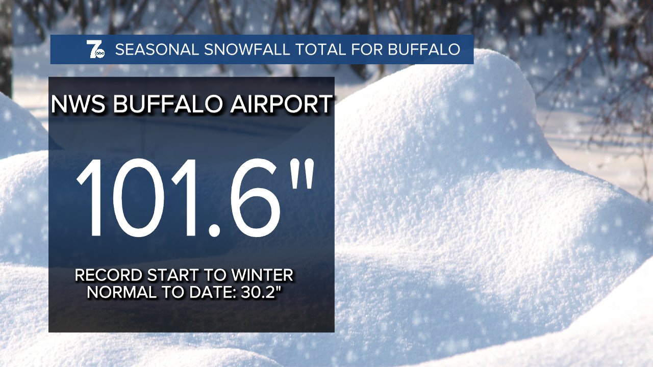
My storm total was 51.3", 152.7" on the year. -
Historic Christmas Lake Effect Blizzard
BuffaloWeather replied to BuffaloWeather's topic in Upstate New York/Pennsylvania
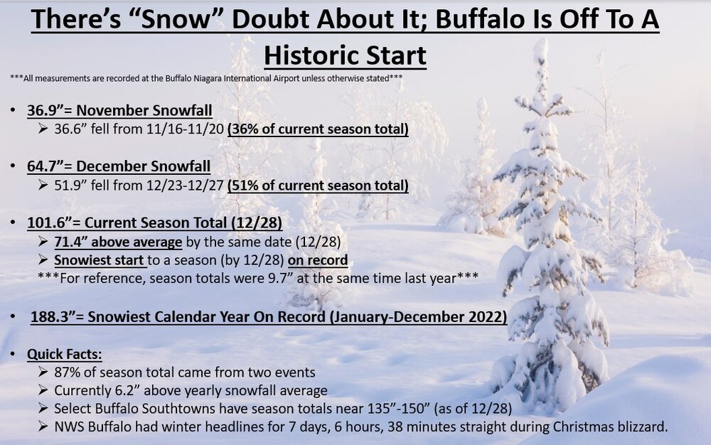
With the cancellation of our winter weather advisories for Jefferson and Lewis counties at 9 PM, it is the first time since 2:22 PM on December 20 that we have had NO winter weather headlines in effect for our area. That's one week, 6 hours, 38 minutes. -
Historic Christmas Lake Effect Blizzard
BuffaloWeather replied to BuffaloWeather's topic in Upstate New York/Pennsylvania
A story like this shows just how severe this blizzard was, can’t even imagine something like this happening. -
Historic Christmas Lake Effect Blizzard
BuffaloWeather replied to BuffaloWeather's topic in Upstate New York/Pennsylvania
-
Historic Christmas Lake Effect Blizzard
BuffaloWeather replied to BuffaloWeather's topic in Upstate New York/Pennsylvania
Totals: https://forecast.weather.gov/product.php?site=NWS&product=PNS&issuedby=BUF -
Historic Christmas Lake Effect Blizzard
BuffaloWeather replied to BuffaloWeather's topic in Upstate New York/Pennsylvania
.HYDROLOGY... There is a small risk for flooding during the upcoming weekend, with any flooding likely to be more of the minor/nuisance variety. Much warmer weather is on the way, and significant snow melt will start on Thursday when highs reach into the 40s. Warm weather will continue through the weekend and into next week with highs in the lower 50s at most locations. There is high confidence in this, however snow melt alone rarely causes flooding. Latest model guidance suggests a couple weak systems will bring generally light rainfall to the region during the weekend, with rainfall amounts generally around a half inch. This is likely to push many of the Buffalo area Creeks and the Black River to action stage, but it should take around an inch of rain from this system before flooding becomes a concern. There`s a small risk this will happen, but in general the flood risk is low but non- zero. Outside of creek flooding, there could be issues with flooded basements in urban areas as the extensive snow pack gradually melts this weekend and into next week. Typically, this would not prompt a flood warning, but this still could be an impact. One other thing to note, is that there are some ice jams frozen in place on some creeks. For example, the gauge at Ebenezer on Cazenovia Creek is reading erroneously high due to an ice jam, and there`s likely a freeze up ice jam on Sandy Creek. Ice thickness is marginal to support ice jams, but these will have to be monitored as the warmer weather moves in. -
Historic Christmas Lake Effect Blizzard
BuffaloWeather replied to BuffaloWeather's topic in Upstate New York/Pennsylvania
I agree with this. I think the only hypothesis that could be made based on AGW are the constant thaws after nearly every event. In a "normal" winter lake Erie is frozen by the 2nd/3rd week of January. The last 10 years or so we're seeing the lake effect season last well into February. We saw 2 examples of that already this year. 80" in the November event and then a massive thaw and again with this event we are going to see 10 days of 40+ degrees. This results in Lake Eries lake effect potential lasting far longer than in past years. KBUF is going to have an above average Nov/Dec in terms of temperature, and they already had 100"+ of snow. That statistic is absolutely insane....