Powerball
-
Posts
14,466 -
Joined
-
Last visited
Content Type
Profiles
Blogs
Forums
American Weather
Media Demo
Store
Gallery
Everything posted by Powerball
-

Texas 2025 Discussion/Observations
Powerball replied to Stx_Thunder's topic in Central/Western States
Avergae highs for DFW this time of year are in the mid 50s. -
Winter 2025-26 Medium/Long Range Discussion
Powerball replied to michsnowfreak's topic in Lakes/Ohio Valley
Pretty (somewhat unexpected) active morning across the OKC Metro this morning with widespread severe t'storm warnings and even a couple tornado warnings. The last time this happened in January was 2021, which foreshadowed a very (for some folks, historic) cold/stormy pattern the following month. -
^^^Cool...
-
If you could re-experience ONE winter event....
Powerball replied to cyclone77's topic in Lakes/Ohio Valley
Since you didn't make location a condition (as your lifetime condition frankly just ain't fair for a lot of us younger folks from the Detroit area), I would say GHD 1 in Chicago... -
Winter 2025-26 Medium/Long Range Discussion
Powerball replied to michsnowfreak's topic in Lakes/Ohio Valley
It's definitely michsnowfreak's time for sure this winter Nickel & dimed to death, but mostly consistent snowcover and cold, lol... -
Texas 2025 Discussion/Observations
Powerball replied to Stx_Thunder's topic in Central/Western States
Believe it or not, despite a roller coastet month tempwise, December 2025 is still on track for a top 10 warmest at DFW, possibly even tying or beating 2023 for #6... For perspective, this will be the 3rd consecutive top 10 warmest December for DFW (2024 was #3) and 4th top 10 warmesr December this decade (for those who might have forgot, 2021 sits at a extremely comfortable #1). -
Texas 2025 Discussion/Observations
Powerball replied to Stx_Thunder's topic in Central/Western States
December 2025 is also on track for the 6th driest at DFW. -
Texas 2025 Discussion/Observations
Powerball replied to Stx_Thunder's topic in Central/Western States
DFW overachieved a few degrees today to hit 84*F (breaking the previous record high of 83*F) CORRECTION: 85*F was the high. -
-
Radar looks awesome for you. Enjoy! Can't say I'm not jealous...
-
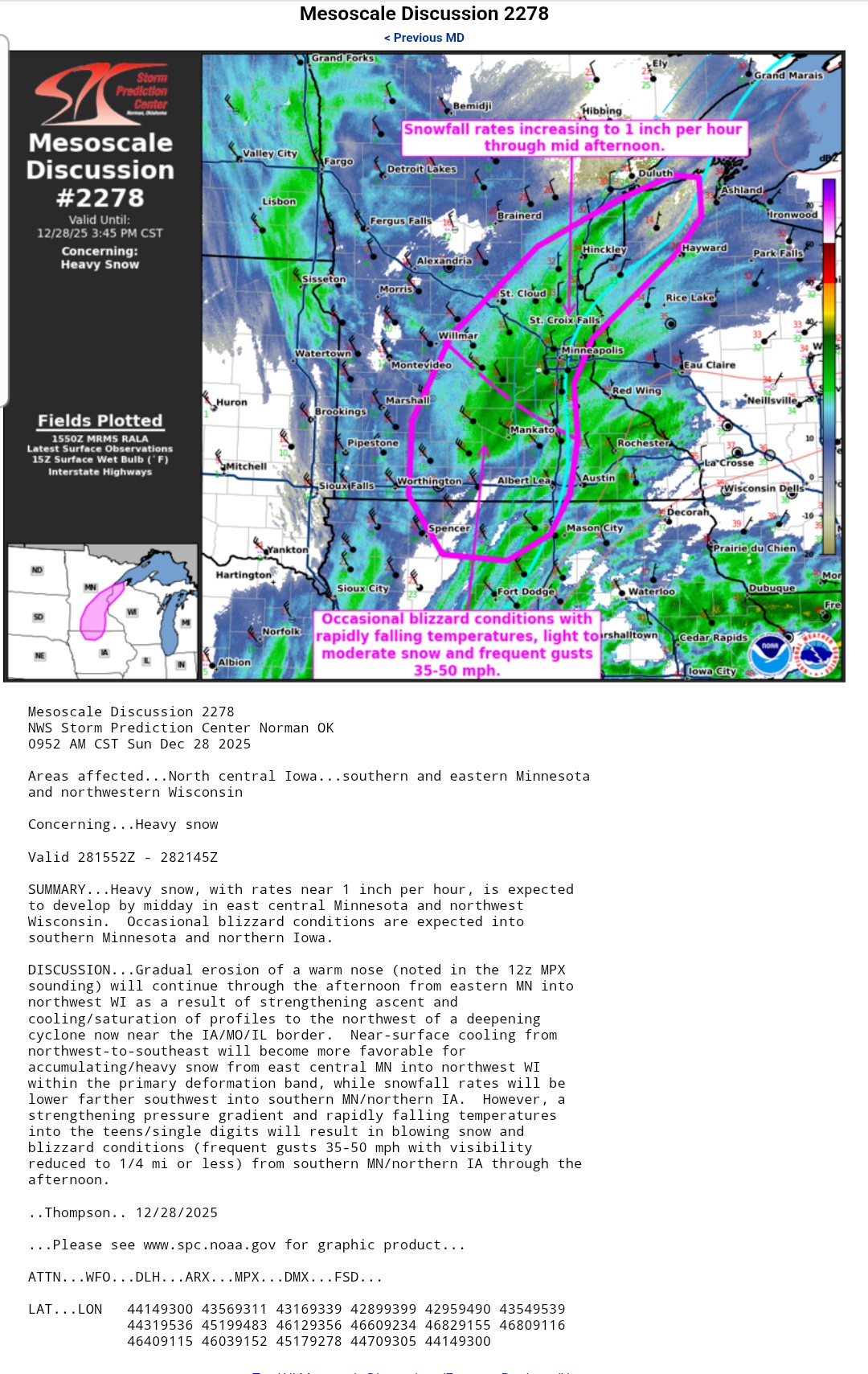
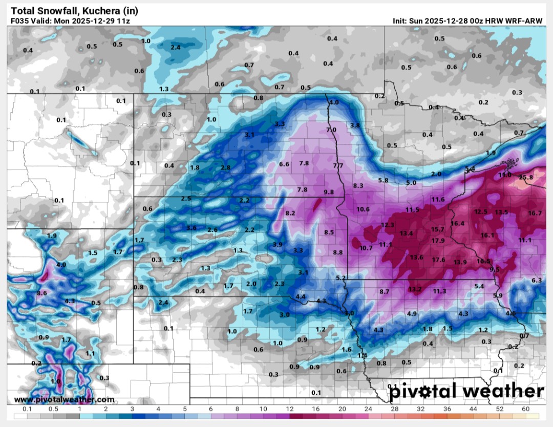
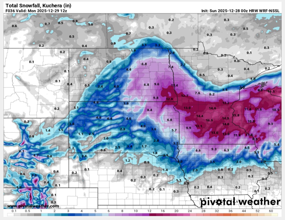
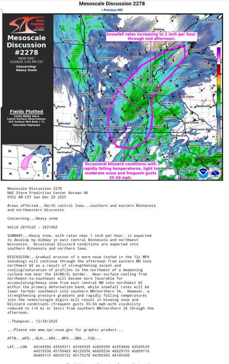
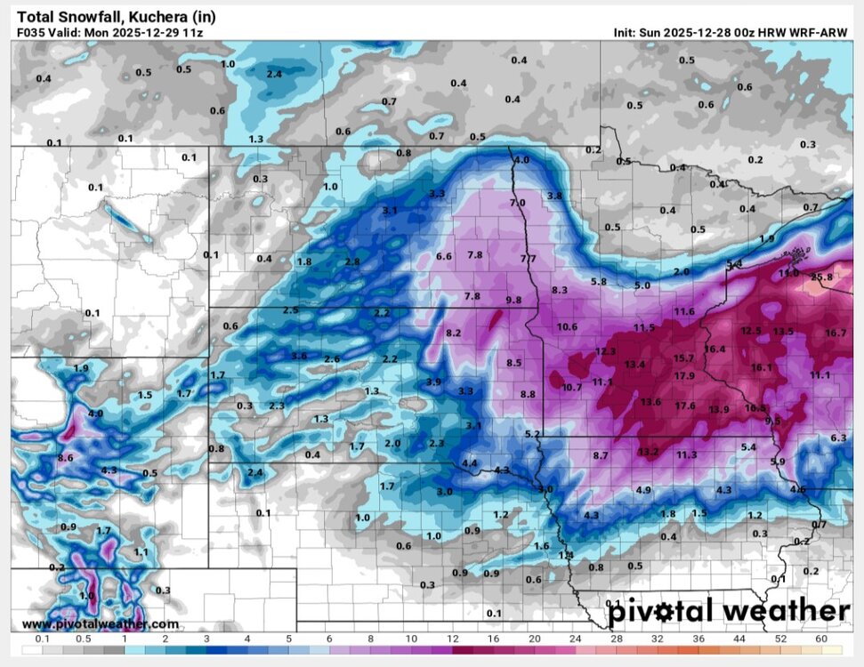
Seeing some TSSN+ showing up in MN, and MSP should be flipping over now (if it hasn't already).
-
Slight risk for severe weather comimg for E. IL and W. IN...
-
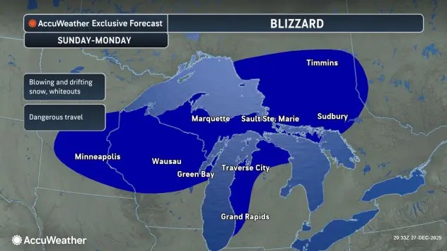
https://www.americanwx.com/bb/topic/62477-december-28th-29th-blizzard/
-
It deserves its own thread...
-
And the fact that they're all beefing up the totals in the 11th hour. It's all going to come down to timing of the phase. A few hours delay (or sooner) could mean the difference between a run-of-the-mill snowstorm or a major blizzard for MSP. Ceiling's fairly high though with the dynamics in place
-

-
Texas 2025 Discussion/Observations
Powerball replied to Stx_Thunder's topic in Central/Western States
DFW tied the record high of 82*F today. -
What's wild is this storm still has the potential to overachieve beyond what's already forecasted for MSP.
-
Texas 2025 Discussion/Observations
Powerball replied to Stx_Thunder's topic in Central/Western States
DFW should end up tying the record high minimum for today (62*F). -
Texas 2025 Discussion/Observations
Powerball replied to Stx_Thunder's topic in Central/Western States
86*F is the official high. -
Texas 2025 Discussion/Observations
Powerball replied to Stx_Thunder's topic in Central/Western States
Already 85*F at DFW as of 1pm (record high was 83*F). -
Winter 2025-26 Medium/Long Range Discussion
Powerball replied to michsnowfreak's topic in Lakes/Ohio Valley
As depressing as that might be, it still beats a crippling ice storm... -
Winter 2025-26 Medium/Long Range Discussion
Powerball replied to michsnowfreak's topic in Lakes/Ohio Valley
Definitely happy this event busted for y'all... -
The NWS wanted to grace us with its finest dad joke for the holidays...

-
Texas 2025 Discussion/Observations
Powerball replied to Stx_Thunder's topic in Central/Western States
There was no record high today at DFW, mainly because the record happened to be out of reach (88*F). However, another record high minimum was set (61*F), breaking the previous record of 60*F.