Powerball
-
Posts
14,420 -
Joined
-
Last visited
Content Type
Profiles
Blogs
Forums
American Weather
Media Demo
Store
Gallery
Everything posted by Powerball
-
Between increased cloud cover, a weaker shortwave, somewhat weaker low level flow and somewhat drier air, today's setup looks a bit more messy than Thursday's. That's not saying much though, because the parameters are still impressive when you disregard Thursday's extremely high ceiling. It's looking more like a damaging straight-line wind threat today than anything. And it seems there will potentially be 2 separate areas of organized activity to watch later this afternoon / tonight. 1. I-20/I-30 corridors in Texas from Abilene to Texarkana (including DFW) 2. North/Central OK, including OKC and Tulsa. Many of the areas that got hit hardest on Thursday in Southern OK and parts of North Texas may very well be spared today.
-
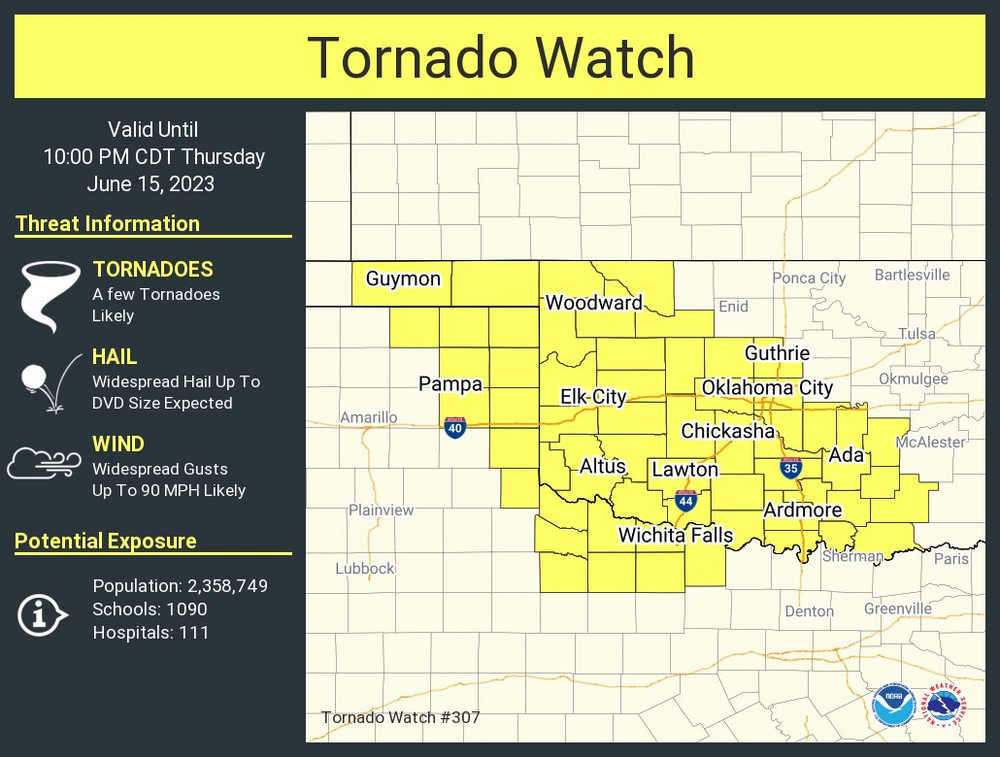
And another one with word for DVD sized hail...
-
-
-
Low level shear is unimpressive (for now), but otherwise, talk about a powder keg...
-
"Hail Up to DVD Size"
-
And there it is...
-
A regular Tornado Watch with strong wording for hail/wind is likely the way they'll go. Looks like some initiation is trying to occur near Altus.
-

Texas/Oklahoma 2023 Obs and Discussion
Powerball replied to Ed, snow and hurricane fan's topic in Central/Western States
Ooof!!!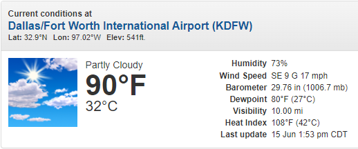
-
Not sure I've ever seen this wording in a MD... Mesoscale Discussion 1076 NWS Storm Prediction Center Norman OK 0149 PM CDT Thu Jun 15 2023 Areas affected...Central/Eastern OK Panhandle...Western/Central OK...Eastern TX Panhandle...Far Northwest TX Concerning...Severe potential...Tornado Watch likely Valid 151849Z - 152045Z Probability of Watch Issuance...95 percent SUMMARY...Intense supercell thunderstorms capable of all severe hazards, including giant hail, hurricane-force wind gusts, and tornadoes, are expected across the region this afternoon and evening. DISCUSSION...Visible satellite imagery currently shows an expanding cumulus field from the central/eastern OK Panhandle down through the eastern TX Panhandle and into far northwest TX. Thus far, most of the cumulus within this field have a relatively flat appearance, with only a few pockets with more vertical development (i.e. over far southwest OK/far northwest TX and central OK Panhandle). Recent mesoanalysis suggests some convective inhibition remains, which is verified with the appearance of the cumulus field. Continued air mass destabilization is anticipated, with the limited convective inhibition likely eroding over the next hour. This erosion of the inhibition coupled with forcing for ascent attendant to the approaching shortwave trough, and additional mesoscale ascent related to the low-level confluence over the region, will likely result in convective initiation by 20Z (perhaps even sooner). The air mass over the region represents a rare combination of buoyancy of shear during any time of the year, but particularly mid June. Forecast sounding suggest MLCAPE from 3000 to 4000 J/kg and effective bulk shear from 60 to 70 kt when storms initiate. These type of environment will result in intense supercells, capable of all severe hazards, including giant hail (3"+ in diameter), hurricane-force wind gusts, and tornadoes. The tornado potential may be mitigated somewhat by the higher LCLs and relatively modest low-level shear. However, given the overall character of the environment, tornadic supercells cannot be ruled out. ..Mosier/Thompson.. 06/15/2023 ...Please see www.spc.noaa.gov for graphic product... ATTN...WFO...FWD...OUN...LUB...AMA... LAT...LON 36000116 36710153 36990125 36970023 35899812 34249711 33809804 33989945 34189999 34620034 36000116
-
Texas/Oklahoma 2023 Obs and Discussion
Powerball replied to Ed, snow and hurricane fan's topic in Central/Western States
The record dewpoint at DFW is 80*F. It's currently 79*F now. -
The parameters over Dallas are already on the extreme end, and we haven't even reached peak heating / shear (not to mentiom, the best surge of moisture is still looming in Central TX). You can see the old outflow boundary from yesterday on the Satellite marked by a congested billowing CU field, slowly meandering NE, although nothing should come of it for now.
-
Today is really escalating quickly.
-
Hmmm, I'm liking the look of the 12z CAMs so far...
-
Texas/Oklahoma 2023 Obs and Discussion
Powerball replied to Ed, snow and hurricane fan's topic in Central/Western States
This "heat wave" is definitely looking to be a lot more messy for DFW and Oklahoma as a whole than what was depicted last week. Still plenty of heat/humidity to be had (seasonably-speaking), but with the upper level low parked over the Great Lakes / Ohio Valley forcing the jet so far south, these areas will seemingly remain susceptible to convective episodes that will force the surface front further SW than what the global models show (thus keeping high temps and solar insolation in check). The extreme stuff still appears to be a lock for SA / Austin and possibly Houston though. -
18z HRRR was definitely a worst case scenario for DFW. The 00z and especially the 06z have backed off a fair bit, with somewhat stronger capping and somewhat slower timing That said, one thing which stands out (and while I'm not entirely convinced on the upscale growth part) is all the drier air above 850mb. This could allow for a few things, which is the cells remaining discrete for a longer period (which would be concerning as low level shear really picks up during the early evening hours), but also for outflow boundaries (with there no longer being a stable surface layer unlike the past 48-72 hours) to either trigger more numerous storms further SE than what the CAMs are currently depicting or cause them to propagate further SE than currently depicted on the CAMs given the negligible capping in place.
-
I'd say Wichita Falls and Lawton (that entire vicinity) for chasing. 18z HRRR was a supercell / tornadic bonanza for DFW proper though.
-
Be careful what you wish for. Parts of DFW have had multiple rounds of monster-sized hail (2-3"+ in diameter) the past several days.
-
Interestingly enough, although we've been sleeping on it, tomorrow is looking even more ominous for all of North Texas and Southern Oklahoma (including better tornadon potential), although capping might be a bit stronger and the flow (albeit still impressive) is a bit weaker
-
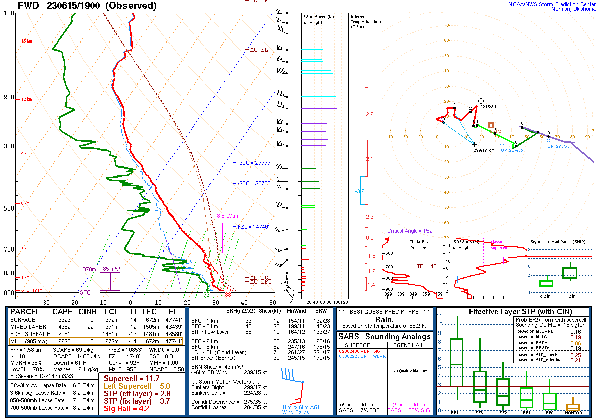
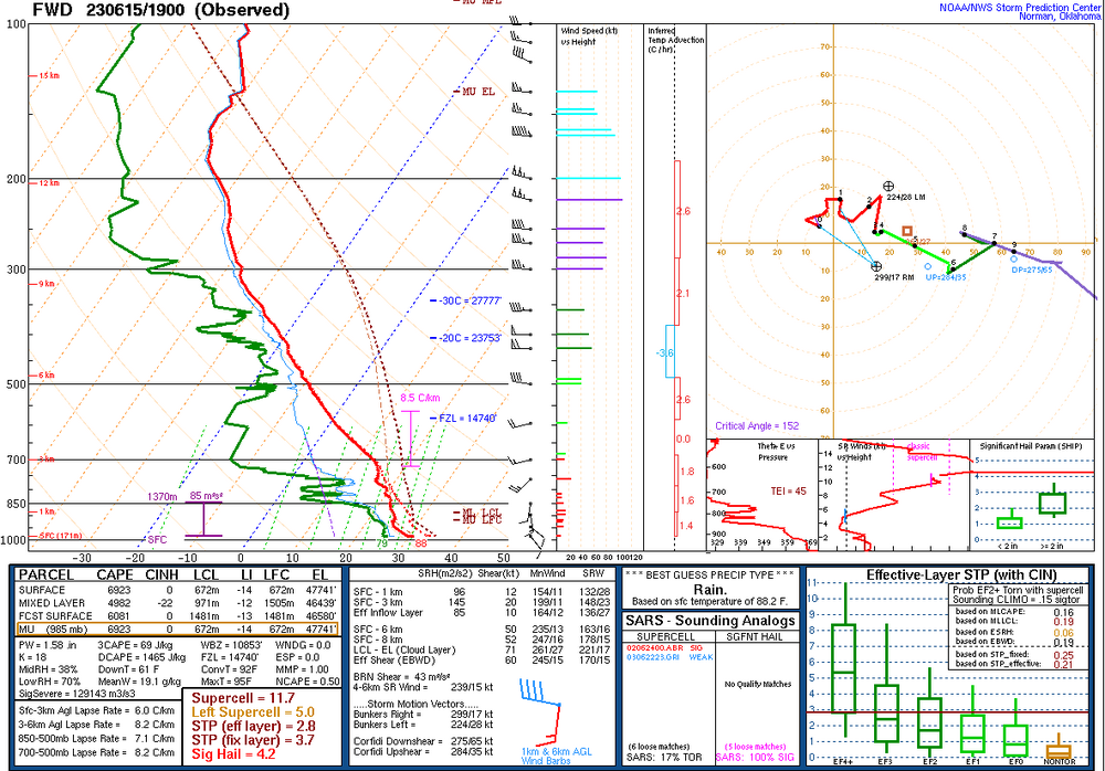
I will say though, for posterity, the parameter right over downtown Dallas are insane. I don't think I've ever see a Craven-Brooks signature of 160K...
-
Seeing the position of the outflow boundary, it's setting up to be a repeat of yesterday with respect to storm location / coverage. For everyone else in North Texas.

-
FWD finally gave up on making fetch happen, and cancelled the watch 1 hour early.
-
It's been a dud for Addison the entire period, probably one of the few areas in the entire Metroplex to not get any severe weather what so ever the past 1-2 weeks (or even a t'storm). I suppose it's a good thing in that we've avoided the hail damage... I'm sure Mansfield, DeSoto and Cedar Hill will get some more monster hail late tonight / early tomorrow morning with the next round looming.
-
*Along/South of I-30 DFW special...
-
This Summer so far is definitely giving shades of 1992.