Powerball
-
Posts
14,420 -
Joined
-
Last visited
Content Type
Profiles
Blogs
Forums
American Weather
Media Demo
Store
Gallery
Everything posted by Powerball
-
We finally got some of that down here for the first time this season yesterday. Made for a nice sunrise and sunset with thick haze.
-

Texas/Oklahoma 2023 Obs and Discussion
Powerball replied to Ed, snow and hurricane fan's topic in Central/Western States
Unless something crazy happens towards the last few days of August with the pattern (I.E. a Tropical System or a massive trough), on average, 2023 will be the 3rd warmest Summer on record for DFW (yes, surpassing 1998/2022 and only behind 2011/1980). The 2nd warmest August on record is likely a lock as well, and 2023 is still in the running to surpass 2011 for the warmest. Still amazing to think about, given it (Summer 2023) was off to a pretty tame start. -
Texas/Oklahoma 2023 Obs and Discussion
Powerball replied to Ed, snow and hurricane fan's topic in Central/Western States
Sunday has trended slightly warmer, so may have one more shot then. -
Texas/Oklahoma 2023 Obs and Discussion
Powerball replied to Ed, snow and hurricane fan's topic in Central/Western States
It's amazing how difficult it has been to get a 110*F+ day at DFW since 2011. We've now had 2 back-to-back Summers amongst the hottest on record, and neither one of them could crack it. This was about the most ideal setup for it to happen too. -
Texas/Oklahoma 2023 Obs and Discussion
Powerball replied to Ed, snow and hurricane fan's topic in Central/Western States
And it's very fitting that a potential 110*F day starts off with a hazy sunrise from Canadian Wildfire Smoke... -
Texas/Oklahoma 2023 Obs and Discussion
Powerball replied to Ed, snow and hurricane fan's topic in Central/Western States
Talk about a back-loaded Summer (2023)... What's also crazy about this number for DFW is that drought conditions haven't been nearly as severe/extreme as they were in the other top 5 years. -
Texas/Oklahoma 2023 Obs and Discussion
Powerball replied to Ed, snow and hurricane fan's topic in Central/Western States
How many 100*F+ days has Houston seen so far this season? EDIT: Never mind. I think I found the answer (26 days as of 8/17). -
Texas/Oklahoma 2023 Obs and Discussion
Powerball replied to Ed, snow and hurricane fan's topic in Central/Western States
-
Texas/Oklahoma 2023 Obs and Discussion
Powerball replied to Ed, snow and hurricane fan's topic in Central/Western States
-
Texas/Oklahoma 2023 Obs and Discussion
Powerball replied to Ed, snow and hurricane fan's topic in Central/Western States
-
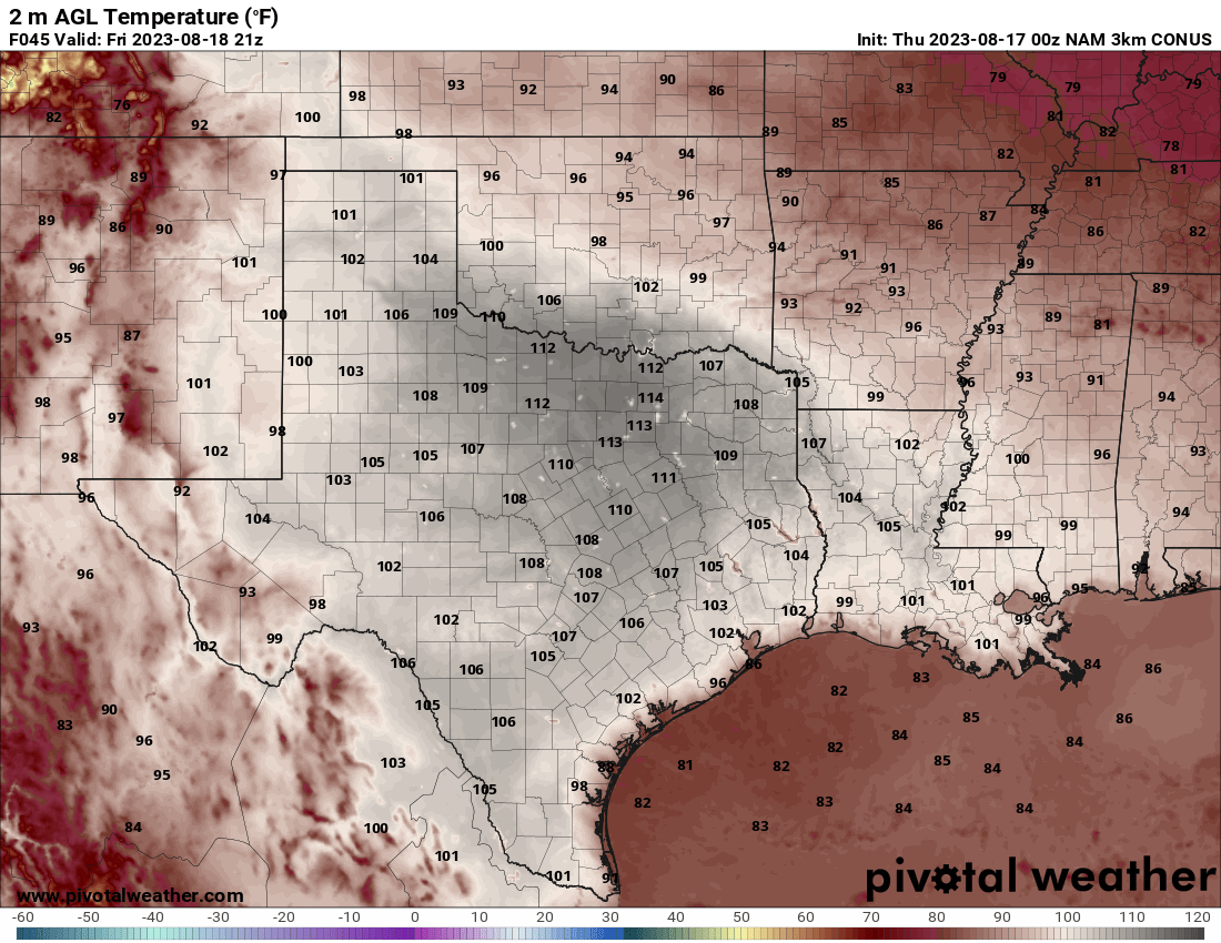
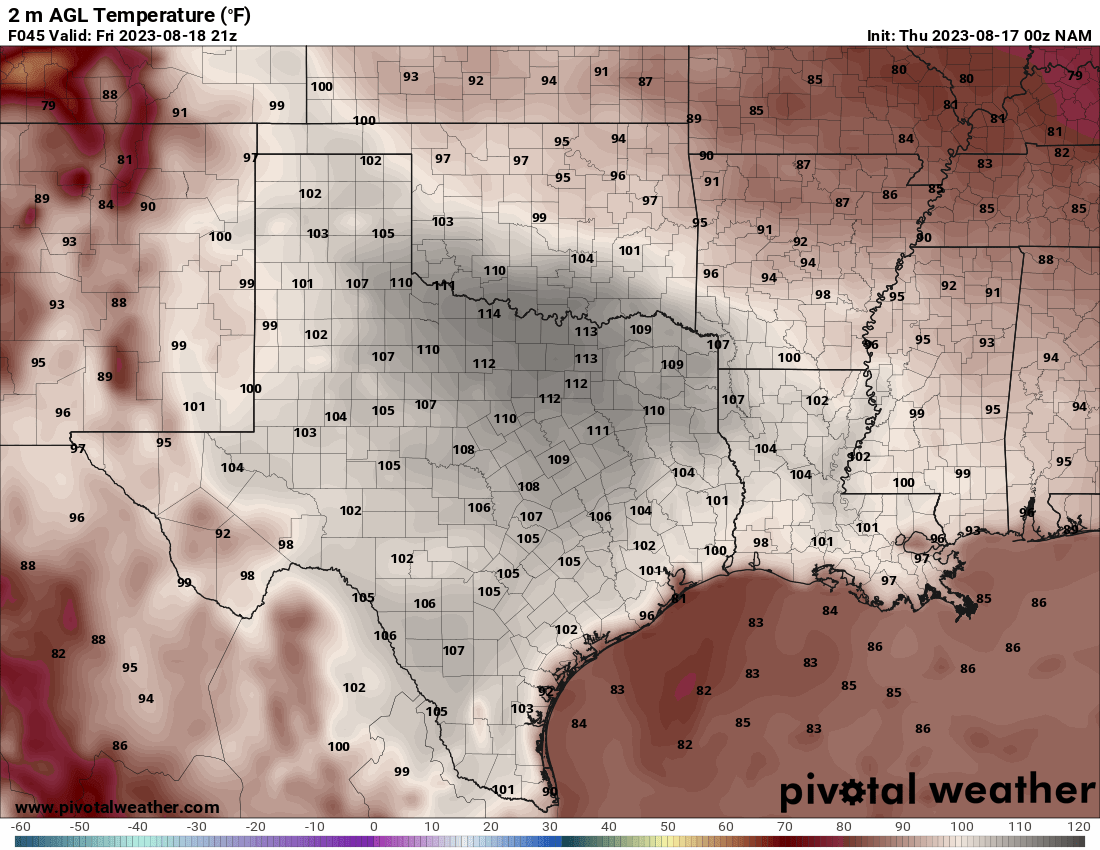
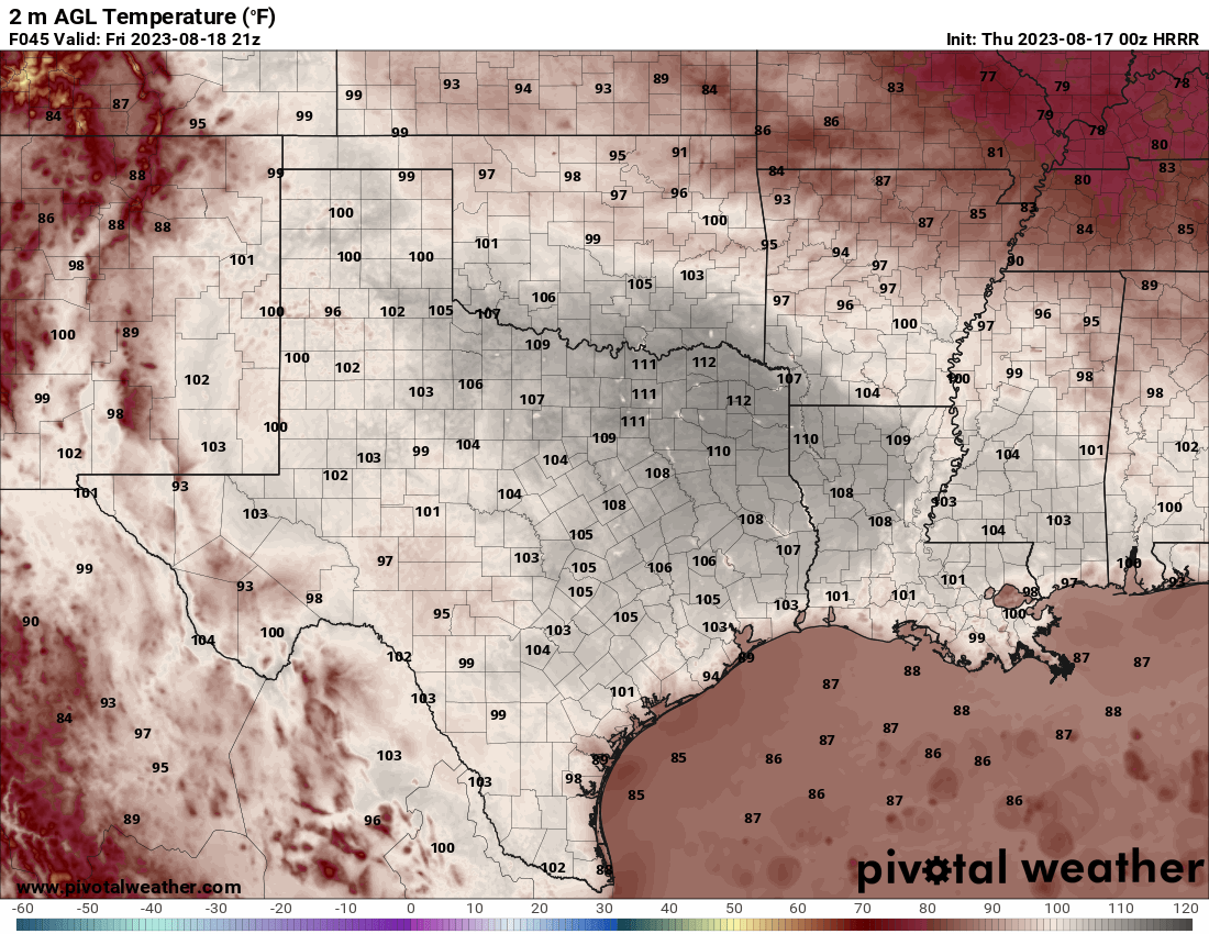
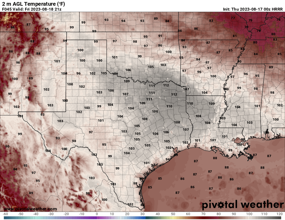
Texas/Oklahoma 2023 Obs and Discussion
Powerball replied to Ed, snow and hurricane fan's topic in Central/Western States
Ooof!!!

-
Texas/Oklahoma 2023 Obs and Discussion
Powerball replied to Ed, snow and hurricane fan's topic in Central/Western States
The 00z EURO OP run brought the tropical wave back in earnest. I'm hoping it *DOESN'T* happen so that DFW can move further up the ranking for 100*F+ days. We're 11 days away from catching up with 2022, and still 4 days away from cracking the top 10 list. We're also in the running for at least the 2nd warmest August on record (2011 being the 1st). And all but 3 of the remaining days in August will have to be 100*F+ to crack the top 10 highest number of days in a month. -
Oh my Sweet Summer Chile... Y'all got several months of that crap incoming after this last heat ridge flexs it muscles.
-
It would be funny if a 600dm death ridge did set up over Alek next week, after the way this Summer has gone.
-
Texas/Oklahoma 2023 Obs and Discussion
Powerball replied to Ed, snow and hurricane fan's topic in Central/Western States
It's 99*F at DFW as of 12pm, but the stiff NW wind has kicked into gear. Just need that last degree (with full solar insolation) to get that 22nd consecutive day... -
Texas/Oklahoma 2023 Obs and Discussion
Powerball replied to Ed, snow and hurricane fan's topic in Central/Western States
Another record for DFW: -
Texas/Oklahoma 2023 Obs and Discussion
Powerball replied to Ed, snow and hurricane fan's topic in Central/Western States
Achieved a record high of 106*F today at DFW (previous record was 105*F set in 1951). -
Texas/Oklahoma 2023 Obs and Discussion
Powerball replied to Ed, snow and hurricane fan's topic in Central/Western States
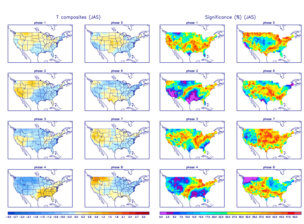
With respect to the MJO, from a temperature standpoint, Phases 8 climatologically-speaking translates to anomalies near normal across Texas. And with respect to the dewpoints, IMO, going with a blend of the GFS and the foreign mosels is likely best. You do have a point about the GFS likely being too aggressives with the lower DPs, but I also think there should be some consideration given for the dry soils & strong subsidence on the backside of the trough to help with efficient heating.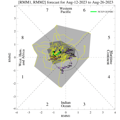
-
Texas/Oklahoma 2023 Obs and Discussion
Powerball replied to Ed, snow and hurricane fan's topic in Central/Western States
Eh, the 00z GFS is notorious for mixing too deeply (even in Compressional Heating setups), and actually has been the slowest to catch on to this "cool down." -
Texas/Oklahoma 2023 Obs and Discussion
Powerball replied to Ed, snow and hurricane fan's topic in Central/Western States
This brief reprieve in the pattern can definitely be attributed to the MJO, as it keeps meandering on the edge of the COD and Phase 8. Kind of annoying for statistical posterity though, because this 1-2 day reprieve will break what otherwise could be an impressive streak of 100*F+ highs and 80*F+ lows for DFW. Still, provided the front doesn't speed on up Monday any more than it already has, this streak should be good enough to surpass 2022 at least... -
-
Pretty impressive-looking hail cores just NW of Minneapolis on radar, although they now appear to be weakening somewhat as they push into the metro area. EDIT: Scratch the weakening part. R.I.P. to people's cars in MSP.
-
Texas/Oklahoma 2023 Obs and Discussion
Powerball replied to Ed, snow and hurricane fan's topic in Central/Western States
Alrighty then... -
Texas/Oklahoma 2023 Obs and Discussion
Powerball replied to Ed, snow and hurricane fan's topic in Central/Western States
With mostly clear skies last night, DFW finally broke the 85*F+ low streak after 6 days. The low this morning was only 8F*F -
Texas/Oklahoma 2023 Obs and Discussion
Powerball replied to Ed, snow and hurricane fan's topic in Central/Western States