Powerball
-
Posts
14,464 -
Joined
-
Last visited
Content Type
Profiles
Blogs
Forums
American Weather
Media Demo
Store
Gallery
Everything posted by Powerball
-

Texas 2025 Discussion/Observations
Powerball replied to Stx_Thunder's topic in Central/Western States
For the first time since 2/8, DFW exceeded 80*F with an official high of 81*F toxay. -
Per Delta, it ended up being 19 inured people in total (out of 80 passengers and 4 crew members), and they've all been released from the hospital as of this morning.
-
Fall/Winter '24 Banter and Complaints Go Here
Powerball replied to IWXwx's topic in Lakes/Ohio Valley
Can y'all please take this shit back? Thanks!
-
Media is now reporting 18 injured people.
-
Media reports are a Delta flight that departed MSP ended up being flipped upside down while landing at YYZ (one of the wings are also missing). Early speculation is that it was weather-related between high winds and snowy/icy runways, but it just happened within the hour and will be investigated. Fortunately, there have been no deaths, but 8 people have been confirmed as injured...
-
It is wild that parts of KY/TN coukd go from seeing 8-12" of rain to over a half foot of snow (which is msjor for that region) within a span of 72 hours...
-
I'm going to play a bit of interference here and just point out in all fairness, this subforum did see plenty of "good busts" during the unusually snowy & active 2005 - 2015 period (although granted, not everyone got a "Big Dog"). Based on past history, these strings good vs. not-so good winters happen in waves and y'all just so happen to be in a wave of not-so-good winters that will eventually pass.
-
4.6" was the final 36-hour total at DTW.
-
36-hour storm total at DTW was 3.4" as of 7am. Probably not final though.
-
Although both this and the last storm fell short (in some cases well short) of expectations overall, I'm sure the snowcover fans are happy. Congrats again to them!
-
DTX has formally dropped the Warning. Now only calling for an additional 2-4" (on top of whatever fell with the WAA snow yesterday).
-
Fall/Winter '24 Banter and Complaints Go Here
Powerball replied to IWXwx's topic in Lakes/Ohio Valley
Yes, please! Because the upcoming forecast this week is not it! -
DTX and IWX both disagree with the bolded per their AFDs, respectfully. Disruption of moisture transport is not be the *ONLY* reason, but it has ended up being *A* reason, unfortunately. The 500mb configuration was never all that favorable for a big dog despite the model runs the day before yesterday, but in the absence of the Tennessee Valley convection, a narrow but quick hitting band of heavy snow would have had a much easier time developing further NW given the instability & forcing that's in place (which is looking increasingly less likely to happen by the hour).
-
Ended up being the case after all...
-
Intereting afternoon discussion from DTX... Snowfall accumulations with this event present more uncertainty than usual less than 12 hours out from the event start, mainly due to a large area of convection over the Tennessee Valley. This creates more opportunity for this event to fall within the tails of the distribution, in other words there is bust potential on both ends. The drier outcome comes from the disruption to moisture transport that could happen with the Tennessee Valley convection. Suspect the deterministic models are latching on to this scenario as there has been a notable trend to the southeast and a drying trend that brings most 10:1 model snow accumulations in below warning criteria as model QPF falls below a half inch. This would present a lower end 2- 4 inch scenario of broad light snowfall. On the other hand, the presence of the mid-level circulation for a 6-9 hour period and glancing period of elevated instability could very well overachieve into a narrow snow band should moisture availability be sufficient. In typical mesoscale fashion, this scenario does not show up well in the guidance, but does afford a higher-end 8+ inch scenario invof metro Detroit where the warning is in effect. It is a difficult task to capture all possible outcomes within a single deterministic forecast or headline, but nonetheless opted for an advisory across most of the area for 3-6 inches and a smaller warning footprint for 5-7 inches across the eastern counties of the cwa given the SE shift in model guidance and potential lake enhancement. Some maneuverability to the headlines is possible throughout this event.
-
And the thing about it is the post in question was taken out of context by the person who overreacted.
-
Only for the lakeshore counties. Everyone else, it's a WWA for 3-6".
-
The 18z HRRR may have been too dry, but the trend can't be denied. Even the 18z NAM came in notably drier. That said, the Detroit area still looks good for 3-6" total. To be fair, that's about what was expected all along before the really amped up runs reared their ugly heads. The big difference is much of the snow will come from the deformation axis and not WAA like originally expected.
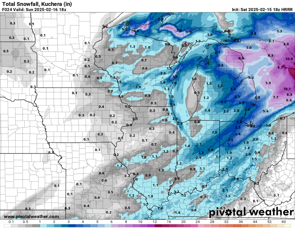
-
18z HRRR
-
The jury is still out there. WAA snows have already underperformed, and model trends aren't looking good for the "main" show tonight/tomorrow. Prior to this system, they were still at a 11-12" departure.
-
I know you're joking, but it's really been a mediocre winter for most of you in the subforum snowfall-wise. There's no point in making it a "tallest midget" competition.
-
The 12z NAM has corrected significantly from the 06z run (although still not as impressive as yesterday's runs).
-
Notable step down on the 06z NAM...
-
Models are pretty much in 2 camps now for SE MI. One shows *ONLY* 4-6", and then there's the other camp that shows widespread double digit amounts. On the plus side, there aren't any duds.
-
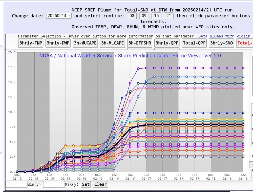
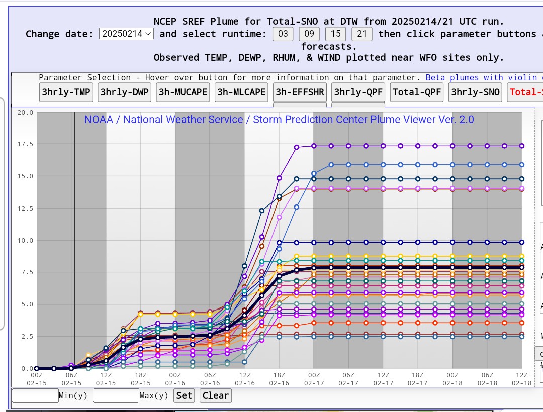
21z SREF plumes for DTW...