Powerball
-
Posts
14,471 -
Joined
-
Last visited
Content Type
Profiles
Blogs
Forums
American Weather
Media Demo
Store
Gallery
Everything posted by Powerball
-
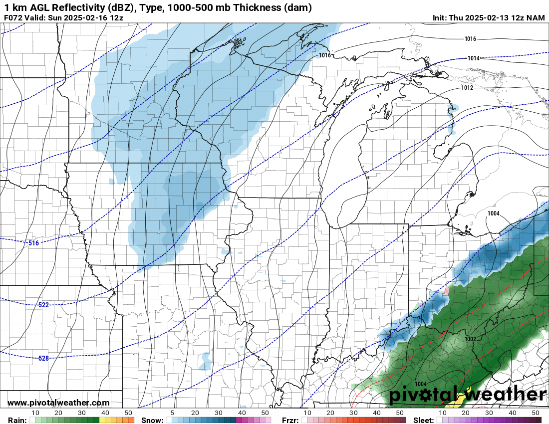
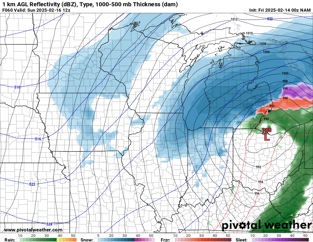
12z HRRR is holding firm with the amped / NW solution. We'll see if the other 12z models follow suit...
-
I have to imagine that DTW, IWX and GRR issue watches for portions of their CWA this morning. Certainly enough of a consensus in model guidance to support it at this stage...
-


-
lol
-
The 18z RGEM is also looking more similar to the UKMET and NAM, for what little it's worth...
-
It did end up similar to the UKMET for eastern areas.
-
I see Detroit has been NAM'd...
-
It appears only 3.6" fell at DTW. Definitely a bit of a underperformer, but perspective is key. It's the best widespread snow event y'all have seen all season...
-
BTW, what happened with the social media rumor that Jim Cantore would be in Detroit? I did check Fox Weather as well, and they're only in Grand Rapids, KC and Chicago...
-
It's definitely shaping up to be your type of pattern. Even if the snow amounts with any one storm don't end up being significant, it should be enough to build deep-ish snowcover with snow on top of snow. Congrats!
-
Isn't that a model projection for the next 10 days? The tweet was an image of temperature departures in January...
-
Lol at the US South standing out as the cool spot...
-
It was Mike Seidel who came to town then...
-
It never rains in Southern California either...
-
I double checked IEM to be certain, and 1/12/24 was *NOT* a warning. 3/3/23 was the one that had a late upgrade to a Warning, and DTX came pretty darn close to pulling the trigger on a Blizzard Warning before mixing occurred (it was *THAT* close to being a biggie).
-
Cool! And will do!
-
There's going to be hard limit on the NW extent of this storm, given the overall flat/progressive pattern aloft. That said, the impressive baroclinic zone in place will support some nice frontogenesis banding in the cold sector. Feb. 2007 and Dec. 2000 might be good analogs...
-

Winter 2024-25 Medium/Long Range Discussion
Powerball replied to michsnowfreak's topic in Lakes/Ohio Valley
lol beavis... -
The models verbatim don't look all that promising right now, but with the impressive baroclinic zone that's appearing to set up, conditions would be ripe for a major winter storm in this subforum (and no, I'm not talking about the ice storm thread) at some point in the next couple of weeks with just a bit of buckling in the upper level pattern. Meanwhile, I'm loving the 80s and near-record highs we're going to have all week!
-
Fall/Winter '24 Banter and Complaints Go Here
Powerball replied to IWXwx's topic in Lakes/Ohio Valley
With exception to London, ON. -
Officially at the airport, the total was 8" That said, those 1895 records are apparently questionable at best per a tweet from the NWS New Orleans. Only thing we know for certain is this was their largest snowstorm in over 125 years (a lifetime). https://x.com/NWSNewOrleans/status/1881916506923213249?t=-9yQBzSyzobIFFrpxrquzw&s=19
-
Fall/Winter '24 Banter and Complaints Go Here
Powerball replied to IWXwx's topic in Lakes/Ohio Valley
One thing I'm very skeptical about though are the QPF numbers that have been confirmed so far (NOLA airport supposedly only measured 0.24"). That said, an average snow ratio of ~12:1 does seem about right judging from the nature of the snow, which is still impressive for a daytime snowfall at that latitude... https://x.com/NWSNewOrleans/status/1881921441308021174?t=83B6o8UBiKdzgjS-XAwLew&s=19 -
Fall/Winter '24 Banter and Complaints Go Here
Powerball replied to IWXwx's topic in Lakes/Ohio Valley
Pretty sure there's quite a bit of slant sticking going on (as well as people measuring drifts), but even accounting for that, it's still quite exceptional for that latitude. -
Fall/Winter '24 Banter and Complaints Go Here
Powerball replied to IWXwx's topic in Lakes/Ohio Valley
https://x.com/NWSNewOrleans/status/1881888699698561085?t=8ZtLrF-7uVxyN8XkDSAe_A&s=19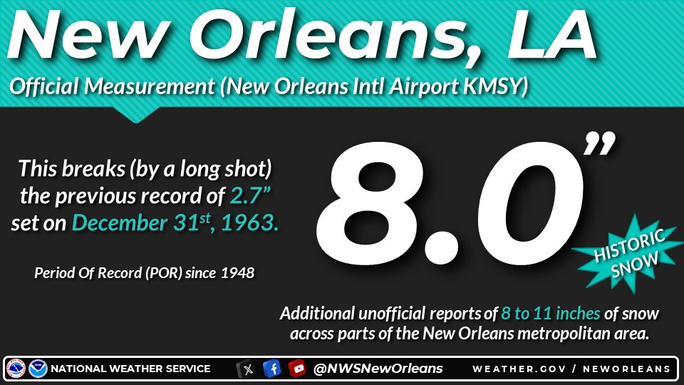
-
Fall/Winter '24 Banter and Complaints Go Here
Powerball replied to IWXwx's topic in Lakes/Ohio Valley
A company from Indiana actually will make (at least) a good $168K from this... https://www.wwltv.com/article/weather/weather-impact/new-orleans-hires-snow-plows-from-indiana-company-new-orleans-snow/289-f308c479-6a99-4338-bb9e-d1e0e76d90db