Powerball
-
Posts
14,471 -
Joined
-
Last visited
Content Type
Profiles
Blogs
Forums
American Weather
Media Demo
Store
Gallery
Everything posted by Powerball
-

Texas 2025 Discussion/Observations
Powerball replied to Stx_Thunder's topic in Central/Western States
Will be a pretty monumental fail for the EURO if it ends up wrong and caving to these other models. "Grandma not mad. Grandma just hurt." -
Texas 2025 Discussion/Observations
Powerball replied to Stx_Thunder's topic in Central/Western States
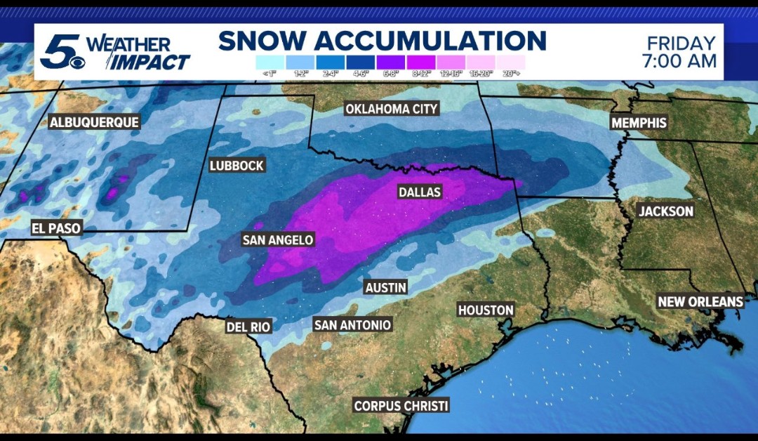
Over 15" for the Northern and Western suburbs... And a crippling Ice Storm just south of the Metroplex... -
Winter 2024-25 Medium/Long Range Discussion
Powerball replied to michsnowfreak's topic in Lakes/Ohio Valley
A little bit of both. But in all seriouaness, I'm always down for a Big Dog, and this one has above-average potential (similar to Feb. 2010 for Dallas). -
Winter 2024-25 Medium/Long Range Discussion
Powerball replied to michsnowfreak's topic in Lakes/Ohio Valley
Still far from a lock (especially with today's model trends), but....webp.7659a8a060b66dab8de7ed5efbce1438.webp)
-
Texas 2024 Discussion/Observations
Powerball replied to Stx_Thunder's topic in Central/Western States
A cold rain would be the lesser evil over Ice, although they're both disgusting. -
Texas 2024 Discussion/Observations
Powerball replied to Stx_Thunder's topic in Central/Western States
Drier *AND* warmer. Real nasty work... But the ICON is a fairly terrible model, even worse than the NAM. -
Texas 2024 Discussion/Observations
Powerball replied to Stx_Thunder's topic in Central/Western States
18z NAM shifted NW, lookimg a lot like the 12z GFS and last night's EURO. Also, update from FWD...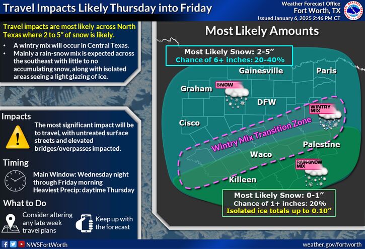
-
Texas 2024 Discussion/Observations
Powerball replied to Stx_Thunder's topic in Central/Western States
Frankie has spoken! https://x.com/frankiemacd/status/1876364861032341522?t=sK9mv32YXQL2TqaV_0vAfw&s=19 -
Texas 2024 Discussion/Observations
Powerball replied to Stx_Thunder's topic in Central/Western States
The bigget threat, power outage-wise, will be poles and limbs weighed down from the plastering of snow if it ends up having a high water content. -
Texas 2024 Discussion/Observations
Powerball replied to Stx_Thunder's topic in Central/Western States
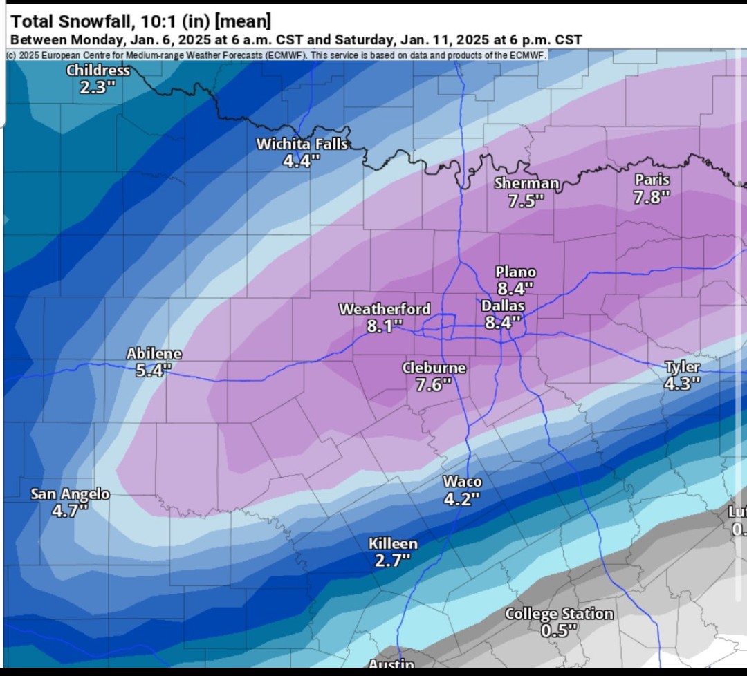
Bear in mind, that is the mean of 50 different alternative outputs from the ECMWF model (not just the OP or operational model). A few duds mixed in there, but also numerous 10"+ big dogs too. The fact that it has been consistently showing a 6-8" mean for Dallas is pretty exceptional, especially given EURO Ensembles have a reputation of being more reliable than the Emsembles for the other models. -
Texas 2024 Discussion/Observations
Powerball replied to Stx_Thunder's topic in Central/Western States
12z EURO Ensemble Mean...
-
Texas 2024 Discussion/Observations
Powerball replied to Stx_Thunder's topic in Central/Western States
EURO Ensembles look their most impressive yet, although like the GEFS they did shift a bit NW. -
Fall/Winter '24 Banter and Complaints Go Here
Powerball replied to IWXwx's topic in Lakes/Ohio Valley
lol...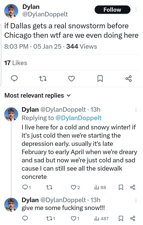
-
That's because not everyone in this sub got anything meaningful from this Winter Storm...
-
Texas 2024 Discussion/Observations
Powerball replied to Stx_Thunder's topic in Central/Western States
Amen to that! -
Texas 2024 Discussion/Observations
Powerball replied to Stx_Thunder's topic in Central/Western States
Take it with a tiny grain of salt (CBS in San Antonio): https://x.com/RDR8ER/status/1876269941646831953?t=3OHCNog_-wVj0wtiFQll0w&s=19
-
Winter 2024-25 Medium/Long Range Discussion
Powerball replied to michsnowfreak's topic in Lakes/Ohio Valley
I bet it feels good to be able to finally say that so late into a season... -
Texas 2024 Discussion/Observations
Powerball replied to Stx_Thunder's topic in Central/Western States
Ensembles remain remarkably consistent, especially the EURO, with both placement and mean totals. -
The Blizzard Warning has been expanded to include all of the KC metro area...
-
Texas 2024 Discussion/Observations
Powerball replied to Stx_Thunder's topic in Central/Western States
For what little it's worth, the EURO ensembles has a fairly widespread 6-8" mean for North Texas, which is impressive at face value. The GEFS and CMCE aren't bad-looking either. -
At best, *IF* everything aligns perfectly, it's going to be a Southern Plains and maybe Mid-Mississippi / Lower Ohio Valley special. With the blocking in the Atlantic and how progressive the trough will be, I don't think it's going to come together with meaningful impact for the majority of this subforum. It's more likely that it ends up being a strung out cold rainstorm for the Gulf Coast.
-
It's not entirely clown map shenanigans, as the potential is definitely there synoptically. But it's a true "thread the needle" setup.
-
It would be funny if Dallas sees a 6"+ snowstorm before Chicago or Detroit. Still think it's a longshot at best though...
-
Winter 2024-25 Medium/Long Range Discussion
Powerball replied to michsnowfreak's topic in Lakes/Ohio Valley
Love to see it! -
I'm sure both Lions and Vikings fans appreciate y'all losing to the Commanders though...