
Violentweatherfan
-
Posts
3,218 -
Joined
-
Last visited
Content Type
Profiles
Blogs
Forums
American Weather
Media Demo
Store
Gallery
Posts posted by Violentweatherfan
-
-
-
46 minutes ago, Ralph Wiggum said:
Closer to inside the outer banks at the surface actually. Farthest S lat it gets is Montgomery, AL before headed NE towards the Tenn Valley. So no real GOM interaction as you noted. Pure Miller B it is? Matches the EPS mean in that regard which is Miller B as well. We don't get coast hugging Miller As often at all. They mostly just slide off the Carolina coast without the phase to draw them N it seems.
I read from a site that Boxing Day storm 2010 was a Miller A. Not quite sure of it's accuracy though, because I did see portions of a video from YT that mention the surface low never really went in the GOM and just developed off the coast. I always assumed that there needed to be GOM interaction.
Miller B storms are easy peasy to recognize because the primary low/clipper travels through Midwest and eventually dies and redevelops off the coast.
If you find the time go and take a look at some of the surface maps from January 96 and check out the isobars/wind field. Just amazing.
-
 2
2
-
-
29 minutes ago, Ralph Wiggum said:
ICON has trended towards a Hybrid Miller A/B....has characteristics of both with slp coming out of Plains moving along the South then up into the Tennessee Valley before transferring off the Carolina Coast.
Then that is straight up Miller B, not looking at the map but if there is no GOM interaction it's all Miller B. Development off the Carolina coast is a positive compared to what we just went through.
-
Don't forget 2015
-
1
-
-
1 hour ago, Hurricane Agnes said:
You're a youngin'. There's plenty more time for non-Miller Bs.

Whenever you get a whiff of "Mr. Miller B" in the air, run the other way from the models, assume a dry slot will set up somewhere near or on top of you, or you get stuck under the subsidence of some Canadian high, and you'll get screwed while someone else cashes in. And if you are fortunate to get under a norlun, celebrate.

Lol, Miller B's are a given. There's no avoiding them.
-
3 hours ago, Animal said:
Who watches the stables? I need Elon musk to build a massive e weather station.
the idea that my forecast was for at a minimum of 8-10 and I end up with 5-6 if it snows to Tuesday night I’d just wrong.
Sorta asking how again how this occurs.
No longer cheering.
Wait wut, Elon Musk.
No
-
7 minutes ago, The Iceman said:
I bet levittown finishes with a higher storm total than Hopewell as that weenie band stalls out over them. I don't think that's ever occurred in a miller B but I guess there's firsts for everything...
You used to be in L-Town right?
-
Light snow, almost non accumulating snow in Langhorne Pa
-
1
-
-
Just now, JMcCaughey42 said:
Good point, hope we get to double digits!
If this continues, through past midnight we should.
-
1
-
-
14 minutes ago, JMcCaughey42 said:
7" in Langhorne, moderate snow
I think that sleet packed down an inch at least. There might be more than that since the beginning.
-
All I can say is damn is it must be frustrating to be a paid met. Everything was there, how can you go against what the "model consensus"? I'm bummed but not gonna rail against those that share what they learned over the years and posted for us to read that a huge Milller B was gonna shellac us and didn't.
-
 1
1
-
-
Just now, Ralph Wiggum said:
Monster sprawling hp in S Central extending into E Canada and the NE with plenty of cold air advection around the PV lobe with the 50/50 locking things in. That would definitely work....the cold and the source of cold are there. Just need the upper features to line up a little more.
Needs to dip southeast an park itself over the great lakes
-
3 minutes ago, Ralph Wiggum said:
Those h5 maps are really close...very diff at the surface tho. Only diffs thay standout the Euro has the stj sw off the SW coast which is likely helping the ridge out west a little more. Also, the euro is better in the AO where the GFS is more overspread into the EPO. 50/50 evident on both.
I'm missing a nice 1040hp over the great lakes, am I looking at the wrong map
-
Just now, Ralph Wiggum said:
Not sure.
Honestly, I can't remember that's why I posted 1996. Shit, I'll offer up the rest of today-tonight as a sacrificial Lamb for a Miller A.
-
 1
1
-
-
Just now, Ralph Wiggum said:
Not there yet and not even sure it gets there, but if look at 144 and go back thru last 6 runs the trend is very good. Plenty of time.
Ya know, I'll sign up. After today...what's the worst that could happen.
-
 1
1
-
-
Seriously, when was the last solid Miller A
-
4 hours ago, RedSky said:
Miller A day 9 on the euro lol
How long has it been, since 1996?
-
1
-
-
4 hours ago, RedSky said:
This might be a bad time to say this but....Eskin nailed this one for most ?

Who's Eskin?
-
6 minutes ago, Ralph Wiggum said:
This isn't a terrible look:

The 144hr look though

-
2 minutes ago, The Iceman said:
Anti snow forcefield in full effect. This effect seems to follow me no matter where I move...

Wow, that's usually prime Miller B location.
-
-
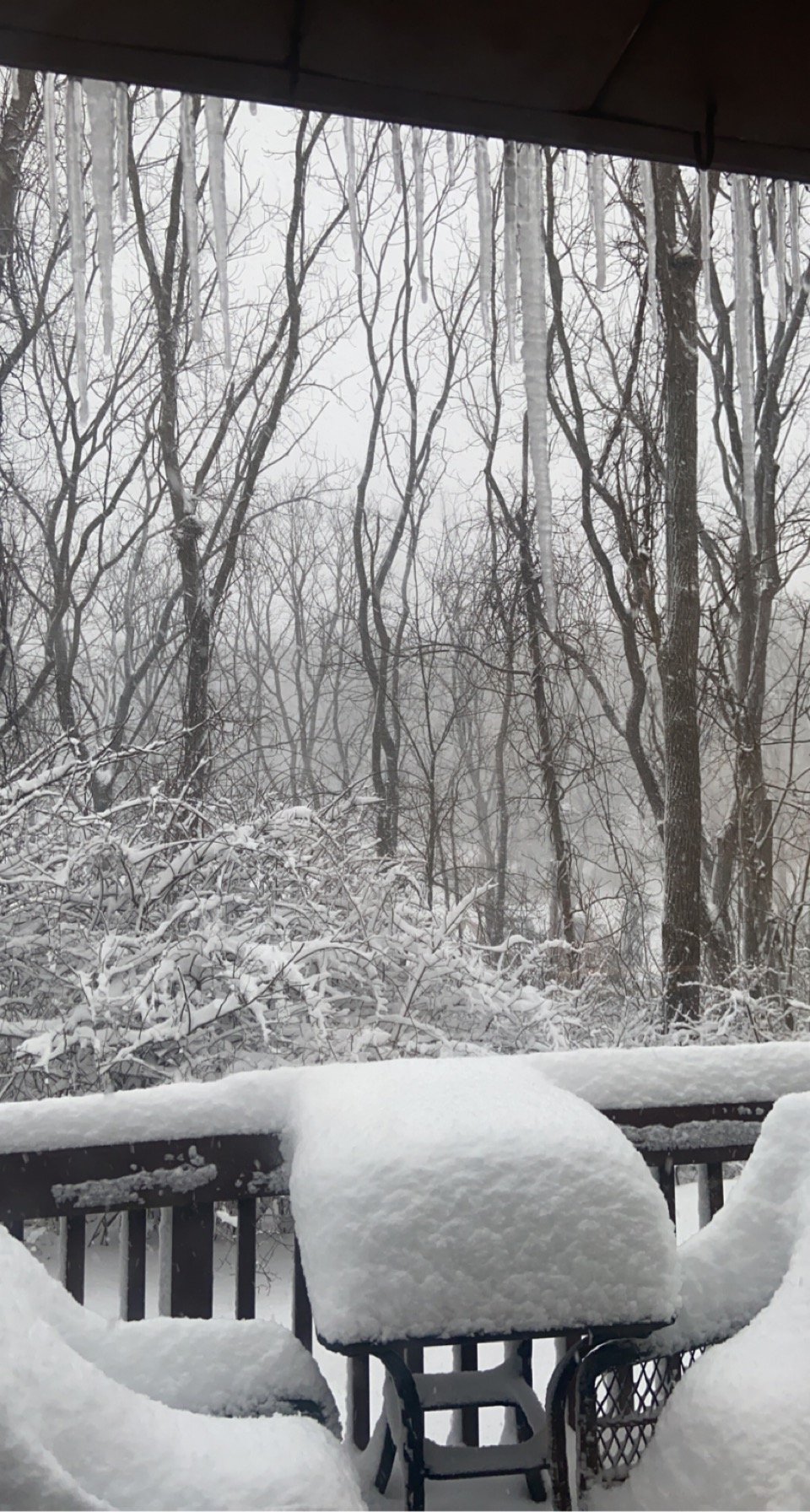
19 minutes ago, LVblizzard said:
The back deck at work in Bath, PA right now
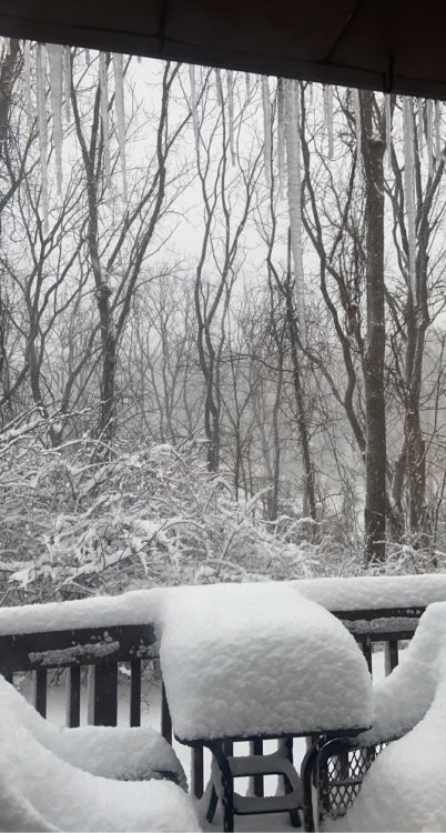
Nice backyard, must be excellent for birding.
-
Just now, MPotter_WX said:
Damn warm pocket aloft is killing me. Snow/sleet mix. Really can’t complain though. You guys had it rough south
Yeah, no complaining there red tagger lol
-
16 minutes ago, JMcCaughey42 said:
Where in Langhorne are you? Seems to be picking up
I've been meaning to make a video and post it here for the longest time offering examples of light-moderate-heavy snow conditions. I still have the video and will eventually get to it. To give you an example of true heavy snow, since you are familiar with the area think of the used car lot on the corner of (North) Oxford Valley road to the Marquee where Target is, I went down to that area during the 2011 storm to capture video and the marquee wasn't visible. That is heavy snow.

E PA/NJ/DE Winter 2020/2021 OBS Thread
in Philadelphia Region
Posted
It was a Champion of Miller A storms and definitely tapped into the Gulf