

Violentweatherfan
-
Posts
3,217 -
Joined
-
Last visited
Content Type
Profiles
Blogs
Forums
American Weather
Media Demo
Store
Gallery
Posts posted by Violentweatherfan
-
-
Just now, Ralph Wiggum said:
I dont like Kucera but they may be closer to reality this time around due to the high ratios in E PA
The wind ralph, the wind.
-
 2
2
-
-
Kuchera and weatherbell maps are a recipe for failed expectations.
-
3
-
 1
1
-
-
45 minutes ago, Kevin Reilly said:
I guess no one forecasts on snow ratios anymore Hmmm??? It will be snowing at 22-25 degrees I would think snow ratios of 15:1 so if the model is showing you 4-6" you can end up with 6-10". I don't know maybe I am missing something here??
28 minutes ago, anthonyweather said:I would add dendrite growth with the wind begs for tiny flakes and lower ratios. Not low low, but more towards 12:1.
this place could be rocking after 00z. EPS spread is west, and boy the ensembles are dragging west!
The wind will limit ratio's, breaking down the dendrites.
-
I rarely make forecast calls, but here goes. I will go with 5" along the I95 corridor, and about 4" near "Newmanville" and I think Jerseysnowrob will be the jackpot zone, topping out at 8". What will keep accumulations down is the timing. These storms always exit faster than forecasted, especially when referring to panels in models.
-
1
-
-
Like the title, it's perfect.
-
Yeah I know the back story but to ease the pain some here is possibly why.
-
1 minute ago, Hurricane Agnes said:
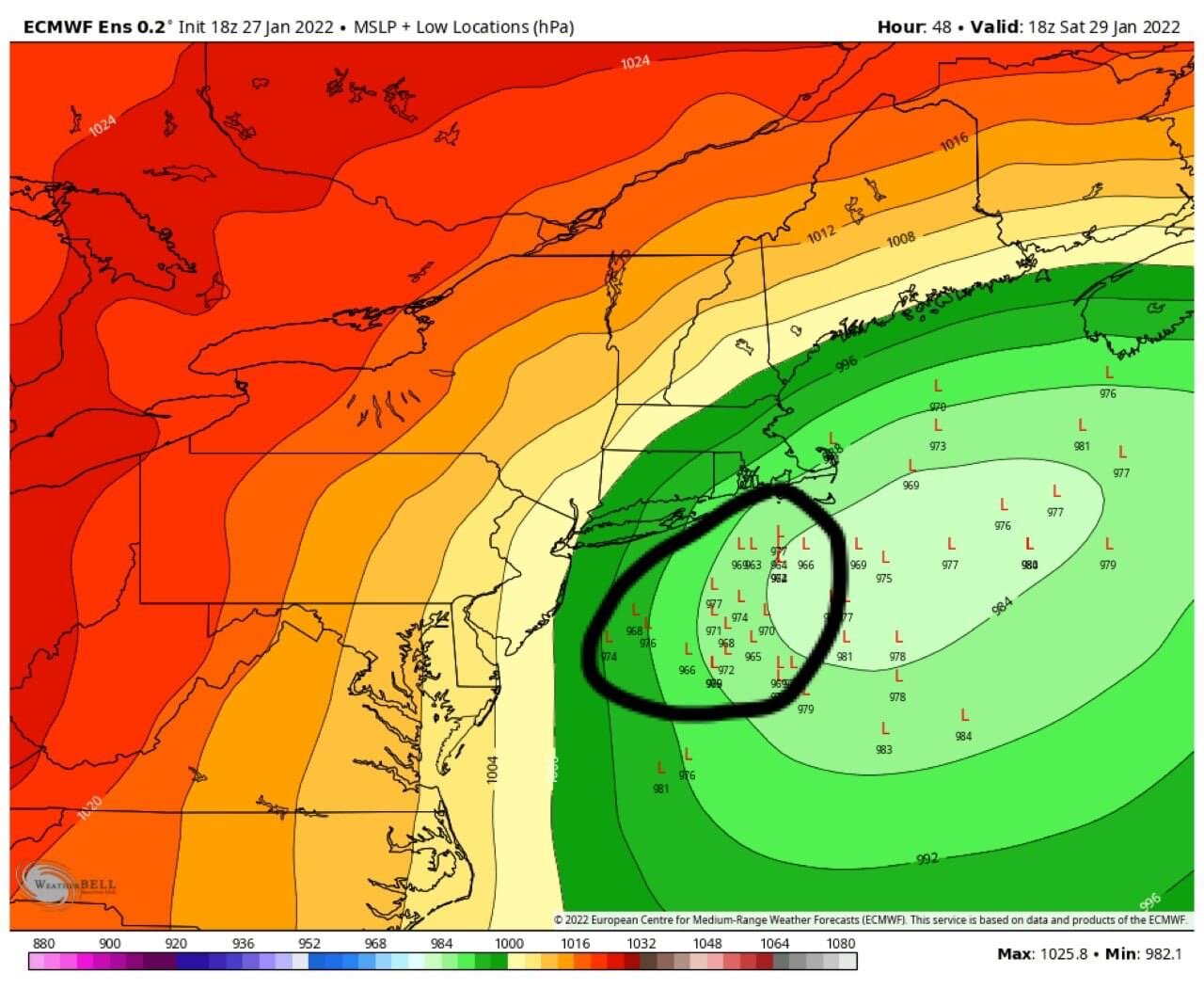
Did an annotation to show the lat/lon. (I blame you for this!
 )
)
Damn, I was off on that. Thanks, still hanging in there which is good
-
5 minutes ago, Hurricane Agnes said:
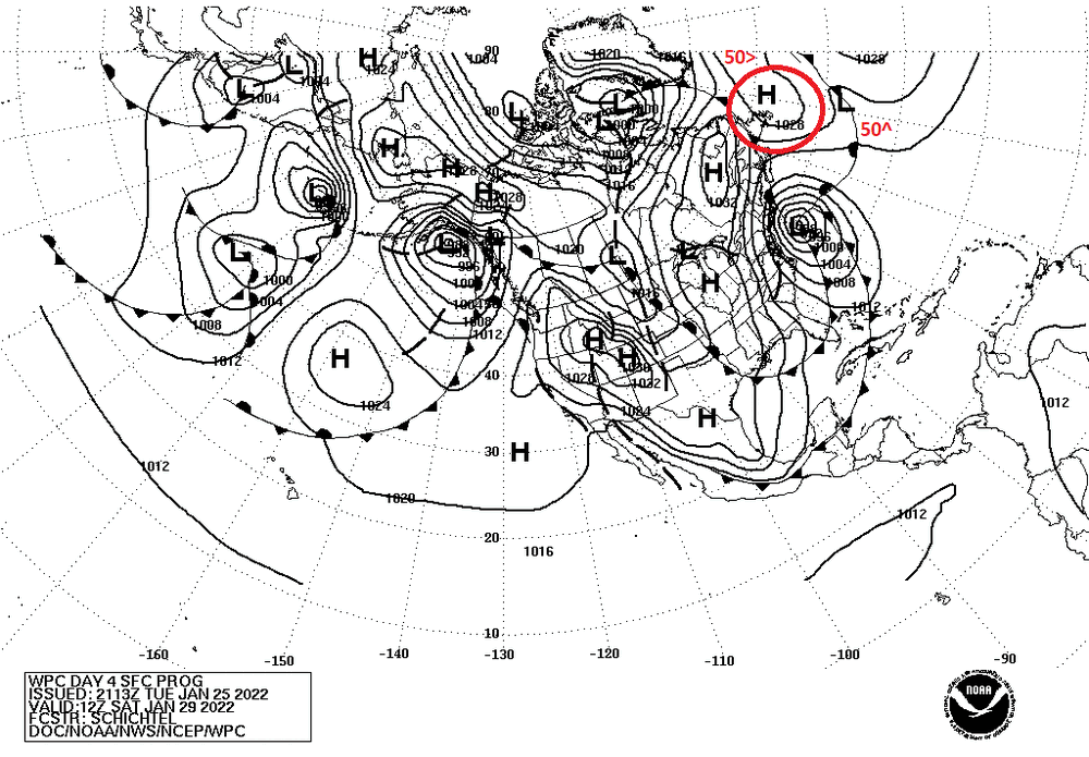
Found where WPC does some surface map forecasts - https://www.weather.gov/forecastmaps
Am attaching their b/w day 4 snapshot (for Jan. 29) where you do see the 50/50 High (at least briefly). The lat/lon lines are there but you have to carefully follow them...
Yeah you can see it gets nudged out of the way but it looks like it prevents it from being a complete miss.
-
3 minutes ago, larrye said:
And doesn't the NAM tend to overstate QPF?
3 minutes ago, MJO812 said:Yes it does
Start and stop times are what will impact accumulations.
-
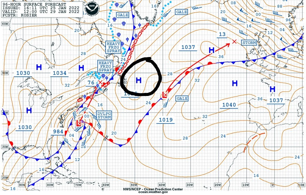
1 hour ago, Hurricane Agnes said:
Did a couple frames. The pulled out view is kinda cool.
Man I'd like to see that with longitude and latitude. I lifted this from the NYC forum, @Doorman
-
8 minutes ago, Heisy said:
Been a long time since we got NAMED
Yesterday
-
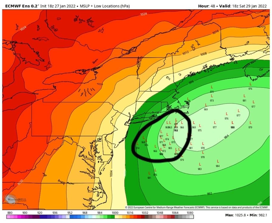
Anyone have a 500MB map of the Euro ensemble. Yesterday there was a 50/50 HP, or I guess you call it a 50/50 ridge. I'd like to see if it's location changed any causing the eastward movement
-
Ignore the snow accumulation and precip maps, but check out the temp and humidity maps.
-
1 minute ago, Blue Dream said:
I'm in Yardley/Morrisville area which looks to be on the cusp
Oops, I have you confused with a different poster, 3-6 will verify. I had you out in Bensalem.
-
2 minutes ago, Hurricane Agnes said:
Well from the Inkie article I posted upthread, including the rest of Tony Gigi's (rainshadow when he posted here) comment -
I think this Euro run might be a bit out to lunch (with a lot of obvious extrapolation going on because it's the 6z), so will have to see what the 12z does with more data.
I think I also read that the NAM and the Euro also tend to overamplify phasing.
-
Just now, Blue Dream said:
I know...I'm hoping we can get 3-6" at this point
This is doable, at this point I do think we'll see snow. I should see those amounts but in your case I'd temper that a bit.
-
Tonight's run will be the key
-
7 minutes ago, Blue Dream said:
Euro keeps hope alive...
Don't forget it has performed poorly this year.
-
1
-
-
Ignore the WxBell clown maps
-
1
-
-
'96 was just massive, it started around 2:00AM Sunday snowed till Monday afternoon.
-
Just now, JTA66 said:
If I recall, that happened with the Jan '96 blizzard (and no, I'm not suggesting we're looking at a redux of that storm here).
PD II was a SWIFE overrunning event too.
-
Another thing to keep in mind is low pressure readings don't equate to increased snow totals.
-
Minus the dryslot please.
-
1
-
1
-
-
Just now, Newman said:
Some will either score a big big coup here, or experience Juno 2.0
Damn you might be a bit West

January 28th/29th Event Obs - From KU to FU?
in Philadelphia Region
Posted
Oh man, the meltdown in the NE forum will be almost to the point of not being able to recover from. You all know those totals aren't going to verify right?