

Violentweatherfan
-
Posts
3,218 -
Joined
-
Last visited
Content Type
Profiles
Blogs
Forums
American Weather
Media Demo
Store
Gallery
Posts posted by Violentweatherfan
-
-
36 minutes ago, RedSky said:
Meso's are giving the Jan 2016 vibe
Hopefully without the dryslot
-
@JERSEYSNOWROB is not gonna like these trends, earlier he was in the bullseye
-
5 minutes ago, hazwoper said:
No it’s NE of Avondale
Oops, my geographical error. Avondale is near Kennett Square way west of Bucks.
-
 2
2
-
-
49 minutes ago, Lady Di said:
I'm sort of like extreme SE PA -where is that? Bucks is north to me, not south, but yes definitely east of me. Will see what differences we get, if any. Beautiful country up there.
I'm almost in the Mid Atlantic forum-LOL
Bucks is waaaay west of you.
-
1 hour ago, Blizzard-on-GFS said:
I have to disagree. I think this map is comically low and is supported by no model. It's straight up misleading. Especially for I-95. Solid model consensus on 10-16".
The map pushing 24 hours old, I wouldn't be too hard on their first call.
-
1
-
-
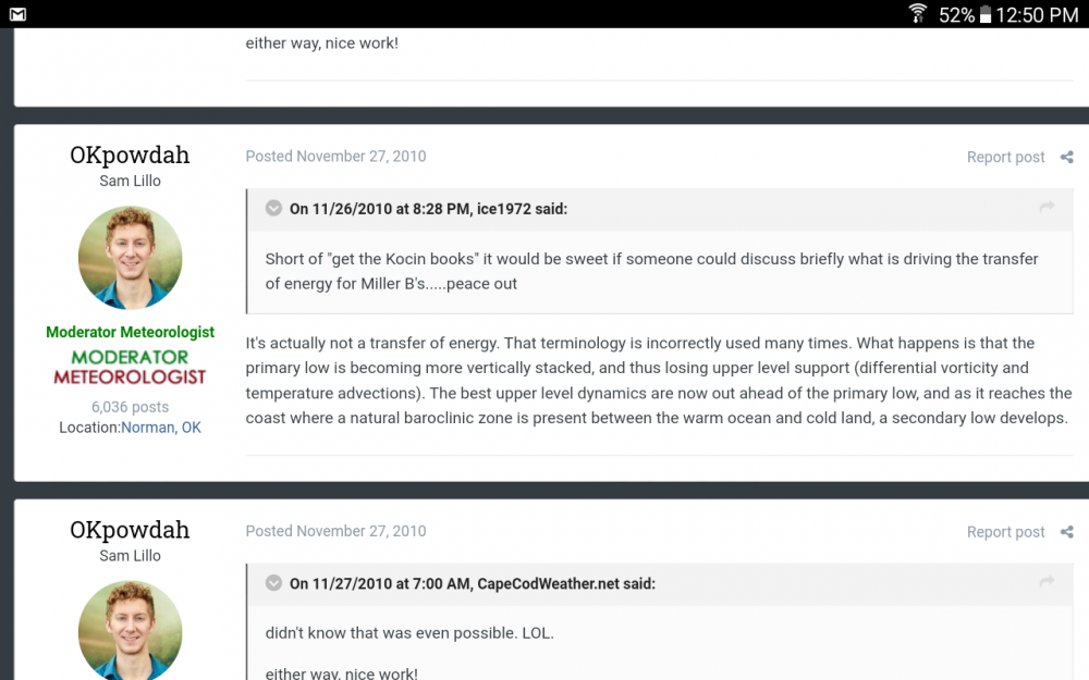
41 minutes ago, MJO812 said:
It is west of the op run. Cmc is also west.
I'm talking about the term transfer and not specifically this storm.
-
1
-
-
1 hour ago, mattinpa said:
Someone in the NYC forum said GFS ensembles are west. Anyway looks good for at least 4-6” but depending on banding and location of transfer, we still could get 12+”.
There really is no transfer of energy.
-
1
-
-
12 hours ago, forkyfork said:
snowy owls have a low tolerance for humans so that is really unusual
-
2
-
-
35 minutes ago, Will - Rutgers said:
psssh what does anyone from Pennsylvania know about weather? cloudy with a chance of 100% chance of Eagles suck. you're gonna see that in your point and click every Sunday and it's probably in the Farmer's Almanac too.
Lol, like it's any better here.
-
18 minutes ago, Ralph Wiggum said:
Really? Upper air was same exact setup. It is actually number 2 on storm analogs for this coming system.
It originated in the GOM, when I have time I'll look for better confirmation. This is from Glen Allen weather.

-
 1
1
-
-
12 minutes ago, Ralph Wiggum said:
Every Miller B is unique but in general you are right. Jan 96 (and there have been others) was more a hit down here, less up there. There are times it can go the other way. Definitely isn't something written in stone.
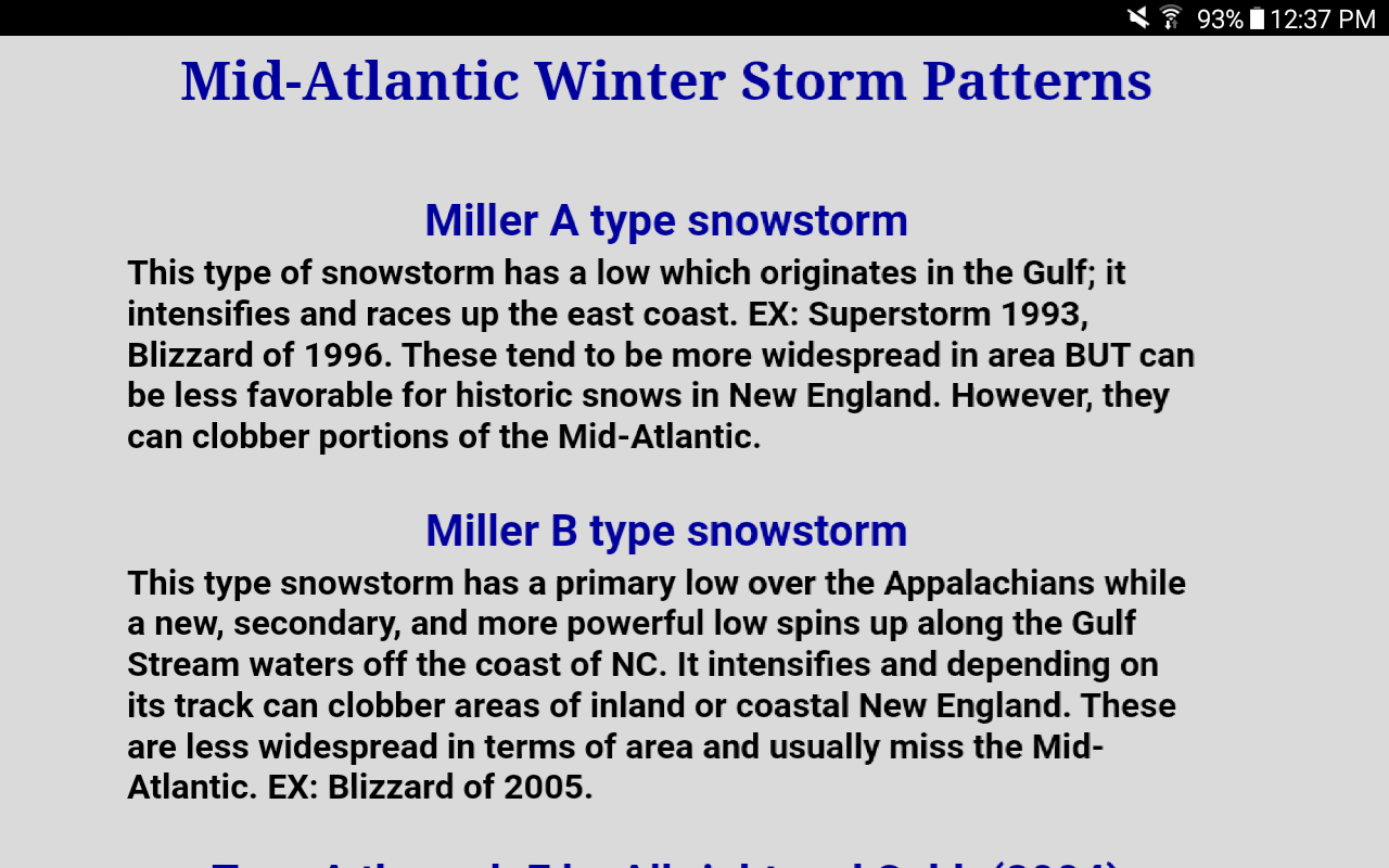
January 6-7 1996 was a Miller A
-
1
-
-
1 hour ago, MJO812 said:
Miller Bs tend to slip east as we get closer. Philly usually does a little worse than my area in NYC with these systems but I think we will all do well. Hopefully the models start consolidating the low more.
NYC is in such a good spot for Miller B storms, anything south of Bucks County - Philadelphia County Pa misses out on intensification. And there is always the dryslot.
-
19 minutes ago, Birds~69 said:
Glenn's 4pm snow map. Honestly I don't what we may be bitching about? Compared to last year this is gold...

The sleet, that's what we are bitching about.
-
1
-
-
4 hours ago, Newman said:
Unless we see these meso models shift the banding back south, I don't see the 18-24" range verifying this far south. Insane forecast by NWS, I still can't get over it. I want it to verify dearly, but I can't get myself to believe it with the 0z and 6z push north.
I think it might be computer generated, and look at the time stamp, from very early this morning
-
1 hour ago, Doorman said:
Yo @Doorman what's up!
-
2 hours ago, jm1220 said:
Jan 2016 was a Miller A El Niño fueled southern stream system. This (Weds) is a system redeveloping due to (hopefully) blocking and confluence north of us, so Miller B. Also should be moving quicker.
Jan 2016 was a Miller B
-
23 hours ago, Wow said:
Cleared cache on server side. Try now
nope
-
same here, zero access unless I am logged out.
-
3 minutes ago, Newman said:
From now until about 1am is all we got. Let's hope we start to pile up.

Lower Bucks not getting any love with that r/s line.
-
-
This might be why the accumulation might still be high along 95, if you watch each frame of the gif it peaks right along lower bucks county.
-
8 minutes ago, Newman said:
It's getting a bit stronger to my eyes:
Nice L-town getting pasted.
-
21 hours ago, JTA66 said:
The storm was a non-event here, other than thunder and a gust of wind or two. The rain stayed to my east but it did drop the temp down to 84F.
Same here, but with a heck of a lighting show.
-
45 minutes ago, Brian5671 said:
JB going torchy in his spring outlooks especially April and May.
Lovely, I couldn't be happier.


Jan. 31-Feb. 2 Miller B storm
in Philadelphia Region
Posted
Lifted this from the MA forum, just enough to nail Bucks County.