.jpg.b9a795a9fe89b3aa2ead015665ae36fe.jpg)
nvck
-
Posts
392 -
Joined
-
Last visited
Content Type
Profiles
Blogs
Forums
American Weather
Media Demo
Store
Gallery
Everything posted by nvck
-
Past few runs of the EPS really trying to sell our first snow chcs of the season up here. Something to keep an eye on, fs


-
.thumb.jpg.ad3a2e31d30aff035044689b311a0540.jpg)
Major Hurricane Melissa - 892mb - 185mph Jamaica landfall
nvck replied to GaWx's topic in Tropical Headquarters
https://www.youtube.com/watch?v=z2HfoQ_HMfY -
Major Hurricane Melissa - 892mb - 185mph Jamaica landfall
nvck replied to GaWx's topic in Tropical Headquarters
either my wifi has totally dropped or the cam finally went down... ETA: back a couple min later -
Major Hurricane Melissa - 892mb - 185mph Jamaica landfall
nvck replied to GaWx's topic in Tropical Headquarters
looks like locations right on the shore are about to enter the eye.
-
Major Hurricane Melissa - 892mb - 185mph Jamaica landfall
nvck replied to GaWx's topic in Tropical Headquarters
Hearing 889 extrap now Edit- check your sources lol -
Major Hurricane Melissa - 892mb - 185mph Jamaica landfall
nvck replied to GaWx's topic in Tropical Headquarters
Insane last half hour or so on IR. Complete ring of -80s wrapping around now https://x.com/wX_nvck/status/1982645615374082373?t=IhnzuFVyTW0CM-DjZO-Ndg&s=09 -
https://deepmind.google.com/science/weatherlab I don't know if this is exactly what you're looking for but I like this site for deepmind tracks, at least.
-
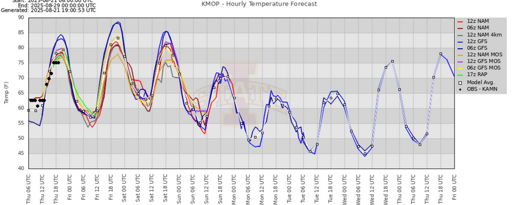
thick cloud cover today has kept the high so far to 66, a nice change from the consistent 70s we've been having. not looking forwards to another run at 80 this weekend.
-
evil, evil tree
-
don't buy that 23 at all, lol. some of these COOP sites have terrible siting and should be taken with a grain of salt
-
Really, really dry august so far, I think based on the (incomplete) xmACIS viewer, this'll be a top-10 driest august for mt. pleasant. Can tell, grass is very brown and some trees are losing leaves a little prematurely. Hoping this mid-week system gets us a good soak, but I don't think it'll be more than a 1/4 inch.
-
lock it in!

-
both the gfs and euro ensembles have a high in the low 60s for next Friday here in mt pleasant. Should feel great after a couple days of 80s
-
Interesting write-up about google's deepmind model, and how it did for erin: https://arstechnica.com/science/2025/08/googles-ai-model-just-nailed-the-forecast-for-the-strongest-atlantic-storm-this-year/
-
Same around here, between that and the 60s, fall is really hitting nice
-
am I crazy or is anyone else seeing a little color on the leaves can anyone else at 43.5+ N confirm lol
-
Looking forward to temps in the mid 60s for the first day of classes on monday, will be a real shock after months of upper 80s and mid 70s dew down here
-
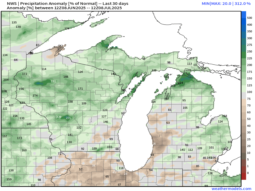
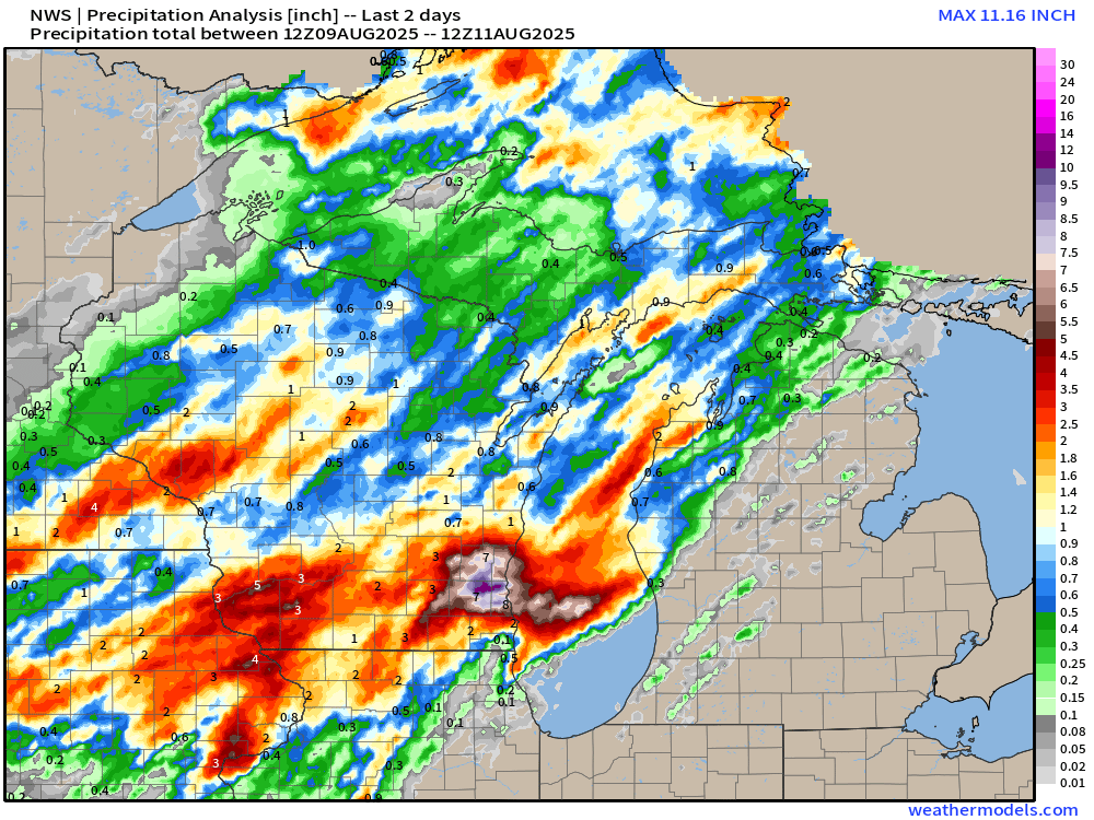
wow, yeah, close to a foot of rain in MKE the past couple of days, and absolutely nothing across the lake...
-
Thankfully aqi is down into the 30s here after 24 or so hours around 100. Sucks what you all are dealing with up north
-
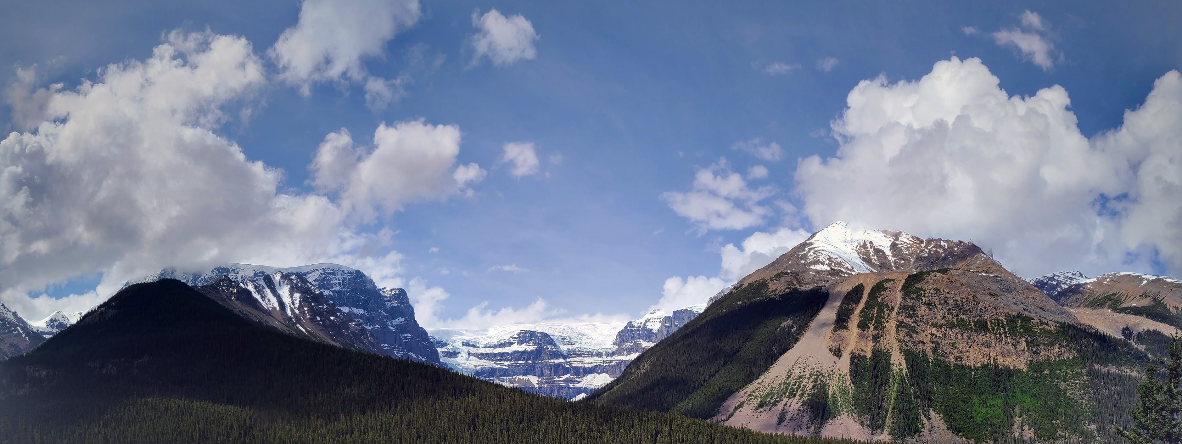
this is an incredible picture, wow
-
Take your meds, man
-

-
dude... take a deep breath... have some herbal tea... take a nap... this is the kinda behavior that makes everyone cheer for a BA season, just to see you take an L
-
Yeah, that bullseye near GR is dismal, 25% of normal rain June 8 - July 8