Bob Chill
-
Posts
36,386 -
Joined
Content Type
Profiles
Blogs
Forums
American Weather
Media Demo
Store
Gallery
Everything posted by Bob Chill
-
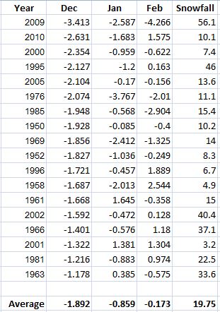
I found some old but very relevant attachments related to AO behavior. First off, assuming Dec AO comes in around -2, this Dec joins some good company. Gotta remove the Nino's so not elite but good company in general Using the AO and enso as simple filters, it brings 2010-11, 2005-06. 2000-01, 1995-96, and 1985-86 to the front of the line. Here's how the daily AO graph played out for 2 of those years. If I can find the time I'll graph 05-06, 95-96 and 85-86 soon. They will be similar tho. I remember looking at this before Unsurprisingly, the 2 biggest storms those years came with a deeply negative AO moving towards neutral leading in. That seems to be a common theme with decent storms in non-nino years. Nino years don't care as much. Big block and southern stream is enough by itself. Lol
-
I missed adding 2015 in that edit. Lol. 09-10 is the big dog grandaddy but there was a ton of dead space that winter even with obscene totals. Dec storm was almost written off 72 hours out. It wasn't a long track like the first Feb storm or Jan 2016. Jan was rather frustrating until the lucky last minute north trend. From a tracking perspective I don't remember 09-10 being busy like the 13-15 stretch. Or Feb/Mar 2003. Those periods are what enthusiasts really thrive in. Multiple threat threads for events with different synoptics is what I define as a heater. It's subjective of course. 13-15 stretch taught us a lot. We can snow from nearly any angle or setup that has a chance.... as long as a difficult to move cold dome is centered close by even if it's running away. Nobody can ever convince me that precip comes before cold because in my yard it certainly does not and when it accidentally does, it's gone before my coffee Eta: once the artic front clears our area, it keeps the door open for some chances. Not none or one and done imo. If hl blocking follows a typical progression with a relax and reload it could crack the door open on a heater period with different setups or even a hostile west track dump. This is what I'm really focused on and why I have little to say leading into the first real cold.
-
We've had plenty of multi-event heaters over the years. Most decent winters require at least one. We're streaky AF here lol Eta: all time heater award has to go to Feb 14th thru March 31st. What a blast that was
-
Agree. To me, for our purposes, next week's weird event IS the pattern change we've been waiting for. I guessed mid month back in Nov and that was too soon. I like everything I see coming up. I'd be happy with any frozen events this month. Especially ones that end below freezing. Lol.
-
This isn't really a Miller B setup in a classic sense. The northern stream "shortwave" on the gfs/euro is actually then tropospheric polar vortex. Lol. And it drops down far west then takes a diagonal path SE with a neg tilted trough stretching like a rubber band. Lol. For us to get a Miller B out of it we would need the TPV to approach from the SW. Or at least from due west at or south of our latitude. Problem is, I can't think of a single time that's come close to happening. Lol
-
Gulf storms that don't fight like hell to rain typically only happen in JFM (mostly FM). Dec gulf storms almost always rain here. We've had more than you remember because they didn't look good cuz it was too warm lol Imo only, the most important thing is deep cold at the surface and mids. I don't mean frigid air. Just a cold dome that pushes at least to the triad in NC or the TN valley. Otherwise return flow in front of anything can chase away a decent column with ease (which is typical in Dec). I have yet to see a single airmass set up proper on guidance since Thanksgiving. Climo is fighting the cold press (as expected unfortunately). Before judging anything so far this very early season... let's wait until an airmass presses down that can actually work for more than 2 days
-
That's what happened in 83 after the artic blast came thru. No storms but several light snow events moved thru with an inch or 2 here and there iirc. That was a long time ago but I remember that holiday specifically for the cold and bit of snow that came with it.
-
The second I saw teens in san Diego I disregarded the euro ball drop solution. We get plenty of deep tpv intrusions in the conus. Centered over the 4 corners? Lol. That happens never so we good
-
Lol. Didn't realize there was an event thread. I'm a noob
-
Gfs drops the tpv west idea this run. Would create opportunity for multiple ways to get something
-
Look at the gfs op h5 NH loop. The big Midwest low rolls thru the 50/50 area and squirts out from under the block. Allows things to amplify and get messy upstream. This part of progression will be easy to track in 4 days or so. It's very important as is the spacing but it's just guessing for now
-
@WxUSAFso after the mini storm train and frozen white Christmas, we can shift our focus on the big dog KU Archembault phased bomb
-
It was a wild stretch. The tpv acted like a block when we needed it. Set the lanes up just right underneath. With a nasty tpv drop like that, effective blocking will happen north of us. Flow will always be fast underneath a big tpv. I'm just calling what I see. I'd prefer less amplification and more blockification but hard to be picky at all rn
-
D10 setup on gfs/euro isn't all that different than how we got snow in Dec/Jan 2013-14. It's also a way to hit a little hot streak. Too progressive for a big storm but not a couple small ones lol
-
The shortwave/ull is actually trackable. Lol. It crawls down the west coast starting a week out and gets picked up by the southern stream of split flow. It's kinda busy underneath the npac ridge. Who knows what flies around the big blue ball dropping down lol
-
12z gfs cooking up Nina Miller A setup for the holidays.
-
Late Dec 83 & 89 analogs keep peppering the lists. Those are the 2 coldest holiday years in the last 40 years. Doubt records are going down but it makes things interesting. More warmth in the oceans and more moisture in the air nowadays...
-
This is foggy memory stuff but iirc the principal is simple. Giant mountains create obstructions for upper level flow and can buckle the flow or "break an existing pattern". The most common times you'll hear people getting all torqued up is when the pac jet is at time travel speed aimed directly at the conus. Upstream torquing can cause downstream buckling. Disclaimer: everything above may be incorrect
-
Our lowest stress coastals (imo only) are the ones that kill an 850 low over or just west of the apps south of harpers ferry. We debate these all the time. Hybrid is the only answer for me and slp does jump the coast. Even when the shortwave is pure southern stream it can still jump and screw just like our epic Nima fails lol. It's a bit subjective. Eta: I'll clarify "lowest stress". A good column and 850 track along or just west of the apps sets our entire area in the crosshairs of WAA snowfall. Often from winterwxluvrs yard to Cape's. Things can get tricky with the coastal but it's already snowed a good bit by then and it was easy to track. I like that. Lol
-
I always come back to simple math... met winter avgs around 10-12" of total precipitation through time. Good or great years are still usually only 20-25% frozen. Lol. Many sit quite comfortably in your math We need chances more than anything to have a good winter. The good years will have a handful of 1-4" snows peppered in the mix with a few nice events. Our 1-4" snows are usually streaky too. Fun when they line up Eta: we usually do well when it's active and "close enough" to snow. 3-4 OK chances in a favorable period of any length usually produces something. How well "something" is received is quite personal lol
-
Labels are muddy for sure. The majority of our big snows are a hybrid of some sort. Plenty lean on the Miller B side of things too. Each storm has it's own pros and cons. Miller As have the higher probability of missing us to the south than hybrids/b's with a big block. Such a "fun" latitude we live at. Lol
-
83-84 was a stinker here but 83 featured a nasty arctic outbreak leading into the holidays. Mid-Dec 83 500mb analogs have been popping up regularly last 4-5 days. It did snow a few inches that Dec pre-holiday. From afar, it doesn't look like a huge artic outbreak is ripe but certainly possible. Something to watch. If the epo ridge starts freezing western Canada, it's only a matter of time b4 a lot of cold pushes pretty far south and east.
-
It's maps like these that suck the air out of the room. It's the very beginning of our snow climo and that always requires at least a modest BN temp profile where it counts. Especially when slp is fighting to bring it down into the mix. In mid Jan, marginal or AN mid level temps to our north work fine because it's pretty cold anyways. I'd love to see snow as much as anyone but temps are not an ingredient we skip over too easily
-
It's a shame there is literally zero deep cold anywhere to help. Mid level temp maps look terrible. Lol. You know there's something really wrong when a blocked surface low totally ignores the baroclinic zone off the coast because it's impotent. So what's left is a complicated mess both at the surface and upper levels. Our "complicated" batting avg needs a pinch hitter or something
-
Even more impressive is even 7 day guidance is busting high. Look at 14 day. That type of verification anomaly isn't very common. Look at the trend since Nov 1st. There isn't an analog I know of that shows AO behavior already in the books that magically flips quickly. There's a few that dumpster fire in mid Jan and beyond. 2011 fits that but that was literally the multi-year blocking base state's last breath. There are others tho