

Herb@MAWS
-
Posts
2,149 -
Joined
Content Type
Profiles
Blogs
Forums
American Weather
Media Demo
Store
Gallery
Everything posted by Herb@MAWS
-
12/16, 5:30am Columbia: 38.9° and light rain, with 1.87" so far on my low-balling rain gauge.
-
Had a little ice on the car top around 7:30am, but generally NOT an icy day in Columbia. Temps were stuck at a minimum 32.4 for a few hours on either side of dawn, but we are on a slow rise now at 11am, sitting at 33.5. So yeah, 33 and rain. Just another cold, rainy day .... while I watch my good friends in Middletown, NY get 3"-5" snow later today and tonite.
-
9am: Temp stuck at 32.4 since approx 6am, after falling slightly from 32.9 at 5am. Roads seem to be fine around the Columbia area. 0.61" rain so far at 9am.
-
IMBY / Columbia: 5am - 32.9 6am - 32.4
-
Columbia 6:15am IMBY = 23.2 [pre-dawn, may still fall a few more tenths]
-
Not much in the way of temp changes today here high 39 low 32
-
Nice temperature rebound today with 41 IMBY, altho BWI to my east was about 47 or 48.
-
Bottomed out at 18.9° IMBY in Columbia.
-
19.1 at 6am Monday / Columbia, Md.
-
Hi temp for me Sunday 33.5° Lo temp Sunday morning 28.3° 100% sunshine
-
Low of 28 pre-dawn with pre-frontal temps rising to 31 by dawn. Back to 29 with gusty NW winds now behind the front.
-
Only seeing very light rain in my snowlight. 40.5°
-
Overnite low 30. Current/6am Friday = 33.
-
Columbia: A bit of sleet mixed in at onset just before noon. 39°
-
bottomed out at 30 overnite.
-
32 IMBY in Columbia nearing 6am Monday.
-
Only 0.57" IMBY in Columbia.
-
Columbia, 7am Sunday -- 64 degrees, 0.01" deluge.
-
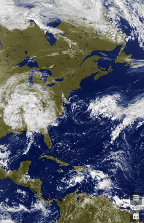
This image from approx 2pm ET Sunday. There's the "never-tropical low that couldn't" to the NE of Bermuda .... and something possibly brewing SE of Jamaica, but the most-tropical-looking thing today may be the over-land system to our west.
-
34.0° for low IMBY. Frost on cars. Light frost in protected grassy areas.
-
35.1 IMBY/Columbia at 6am. May go slightly lower before sunrise?
-
36 for my low.
-
0.33" IMBY as of noon with rain picking up a bit again. Morning low 59.8°.
-
37 IMBY at 7am. Feels outside like I'm back camping at 2000' in WV, as I was earlier this week. Except I'm WARM inside my home!
-
looks like 59 today at BWI.


