

Herb@MAWS
-
Posts
2,149 -
Joined
Content Type
Profiles
Blogs
Forums
American Weather
Media Demo
Store
Gallery
Everything posted by Herb@MAWS
-

Feb 12/13 Event Quest for Blues to Envelop More Rather Than Less
Herb@MAWS replied to North Balti Zen's topic in Mid Atlantic
Local text forecast added 20% of isolated snow showers after 3am Monday. -
Feb 12/13 Event Quest for Blues to Envelop More Rather Than Less
Herb@MAWS replied to North Balti Zen's topic in Mid Atlantic
About 1” with very lite snow continuing and temp 33.3. Looked outside at 2:30am and it was coming down nicely and starting to stick on grass and car tops with temp around 35-36. -
Feb 12/13 Event Quest for Blues to Envelop More Rather Than Less
Herb@MAWS replied to North Balti Zen's topic in Mid Atlantic
Snowing at a decent rate here in Columbia with 36°. Grass is slowly whitening. Cars now are just barely topped -
Feb 12/13 Event Quest for Blues to Envelop More Rather Than Less
Herb@MAWS replied to North Balti Zen's topic in Mid Atlantic
Bring on the Deathband -
Feb 12/13 Event Quest for Blues to Envelop More Rather Than Less
Herb@MAWS replied to North Balti Zen's topic in Mid Atlantic
Imby I’ll consider 1-2” a good event. 1/2” - 1”: eh, but ok I’ll take it. < 1/2” = event fail A whitened ground the morning after: consolation prize -
Feb 12/13 Event Quest for Blues to Envelop More Rather Than Less
Herb@MAWS replied to North Balti Zen's topic in Mid Atlantic
Where is “here”? ? -
LWX afternoon disco not bullish but also not discounting snow possibilities.
-
Flying home from Puerto Rico today. Bring on the snow! ❄️❄️❄️❄️❄️❄️
-
It’s “The Moops”, Bubble Boy!
-
January 28-29 2022 Miller abcdefu Storm Obs/Discussion
Herb@MAWS replied to mappy's topic in Mid Atlantic
It’s 81 at 10am here in San Juan. Arrived 4am today. Bittersweet missing the event but I guess all in all I really didn’t miss much in central Md., as expected Pretty bumpy plane ride leaving BWI yesterday evening. -
January 28-29 2022 Miller abcdefu Storm Obs/Discussion
Herb@MAWS replied to mappy's topic in Mid Atlantic
Left Columbia 4pm Friday in the snow. Now in San Juan at 73°. Forecast 81 on Saturday. Enjoy the snow! -
If I wasn’t packing to catch a Saturday 6am flight from BWI to Puerto Rico........ I’d take u up on this. ✔️
-
Morning low 11.3, 2nd coldest of the season IMBY. My upcoming Saturday 6:30am flight out of BWI heading to Puerto Rico could be *interesting*.
-
Leaving from BWI Sat morning for Puerto Rico -- and 80's. That should almost guarantee Saturday snow! Currently 33.5 in Columbia at 9:30am.
-
11.2 at 7:30am in my part of Columbia. Sun just breaking the horizon, could lose another 1/10th degree or so.
-
24.3 high temp today in Columbia.
-
Jan 21 - 22 Weekend SE VA and Eastern Shore Snow
Herb@MAWS replied to stormtracker's topic in Mid Atlantic
-
Sun is up. Looks like a Friday morning low of 14.2 IMBY.
-
Jan 21 - 22 Weekend SE VA and Eastern Shore Snow
Herb@MAWS replied to stormtracker's topic in Mid Atlantic
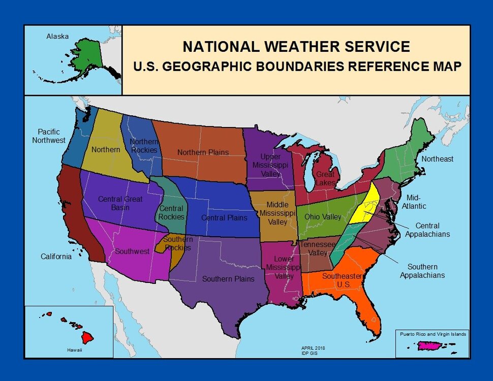
Pulled this from a NWS site. Not perfect, but better. Certainly one can easily question this breakout for climate/weather purposes (e.g, MD and DE in NE US; or KS in the South !?) needs a Mid-Atlantic region! -
I was in Austin during Thanksgiving and also made it out to the hills one afternoon to go to some wineries. Very warm when I arrived, low 80s. There were one or two unseasonally cool days — cool for them for November (chilly breeze, daytime 50s) — and more than just a few of the locals were running around in shorts and tee shirts.
-
Thursday 1/20/22 Stat Padder Discussion and Observations
Herb@MAWS replied to stormtracker's topic in Mid Atlantic
It has pretty much been a steady, light snow (small flakes) for last 30 mins. Total precip has been 0.41". Nothing sticking here yet. 35.3 degrees. -
Thursday 1/20/22 Stat Padder Discussion and Observations
Herb@MAWS replied to stormtracker's topic in Mid Atlantic
Steady moderate snow now with parachutes mixed in, temp down to 35.8. -
Thursday 1/20/22 Stat Padder Discussion and Observations
Herb@MAWS replied to stormtracker's topic in Mid Atlantic
Nice flakes now, sometimes mixing in with a little rain, but it is snowing and it clearly wants to snow now -- a little late to the non-party. Temps down 1/2 degree in last 15 mins, down to 36.4 -
Thursday 1/20/22 Stat Padder Discussion and Observations
Herb@MAWS replied to stormtracker's topic in Mid Atlantic
Quickly mixing/turning to snow, 36.9. -
Thursday 1/20/22 Stat Padder Discussion and Observations
Herb@MAWS replied to stormtracker's topic in Mid Atlantic
A few gloppy white things falling with the light rain. Temp down to 36.9.


