MDScienceTeacher
-
Posts
332 -
Joined
-
Last visited
Content Type
Profiles
Blogs
Forums
American Weather
Media Demo
Store
Gallery
Everything posted by MDScienceTeacher
-
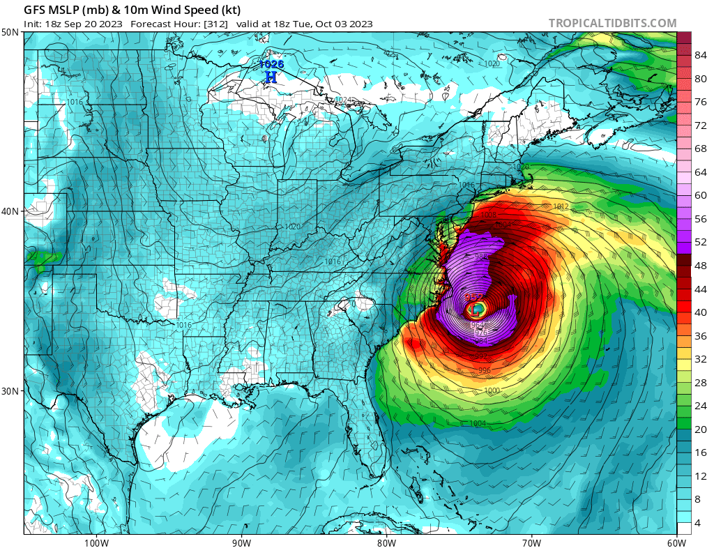
I just spent 45 minutes comparing the last 4 runs of the 264 hour + GFS. it’s gonna be a long winter.
- 1,295 replies
-
- 3
-

-

-

-
- wishcasting
- almost winter
- (and 1 more)
-
The next storm turns nw directly in to Delmarva
-
Storm Daniel and medicanes
MDScienceTeacher replied to gallopinggertie's topic in Tropical Headquarters
Tropical is a high bar.. at least it used to be before NHC started naming ever cluster of thunderstorms producing a gust over 38 mph.. that being said the Mediterranean is not capable of producing tropical storms. This is why these storms are not tracked as such.. The reality of the situation is that the Infrastructure didnt hold in Libya... in order to understand why we would need to go in to the geopolitical realm and thats a no no here. -
Sometimes you need to live a little and let it rip! In 2013 I went to see Fun. at Merriweather. There was stalled out severe storm that dumped for an hour straight. Lightening everywhere. They kept playing. I was in the field the whole time. That was the most memorable concert experience of my life...
-
Not trying to downplay what is for sure to be a major disaster with catastrophic flooding in the Southwest.. but Watching WX Twitter go nuts over Hurricane Hillary is amusing.... post after post describing this is some sort of once in a life time event.. you only have to look back to last year to Hurricane Kay with a 100 mph wind gust in San Diego County.
-
What does 1.10 ± 0.16 C mean? Is this the Average Global Temp anomaly for the month of June?
-
Forgot to mention, I went to Utah last weekend and did some hiking.... Above 8000 feet there was still 6 feet of snow on the ground. Truly astonishing. We got to hike in shorts in 60 degree weather on snow pack! The ski resorts were still open also. Our waitress at a restaurant in Park City said that they are gonna try to Ski on Fourth of July this year in Snow Bird!
-
March Medium/Long Range Thread: The Empire Strikes Back
MDScienceTeacher replied to stormtracker's topic in Mid Atlantic
This is purely anecdotal and very much isolated to winter weather events, but ever since the the major upgrade in 2019, the GFS has been kicking the euro's ass when it comes to these long range disagreements. Look at the last storm. -
March Medium/Long Range Thread: The Empire Strikes Back
MDScienceTeacher replied to stormtracker's topic in Mid Atlantic
Looks like a possible Norlun Trough setting up in the 8-10 day period. -
I am sure it will be Rocking in March.. so much so that someone in Westminster will get 2 inches of snow that melts before it stops snowing.
-
Winter 2022/23 Banter Hangout
MDScienceTeacher replied to Chicago Storm's topic in Lakes/Ohio Valley
Wow.. that is really scary and unfortunate. If I lived any where near there, I would go and get a baseline set of testing and imaging just in case the shit hits the fan. Check out the radar plume from the fire: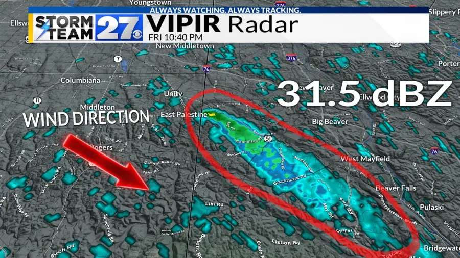
-
Winter 2022/23 Banter Hangout
MDScienceTeacher replied to Chicago Storm's topic in Lakes/Ohio Valley
Concerned downwind citizen here. Is everything okay in Ohio and the surrounding area? Based on what I am seeing, it seems like there is some sort of major environmental catastrophe happening in East Palestine.. Like someone f-ed up really bad. If it werent for the aliens, I would think it would be major news.. but for some reason, none of the main stream outlets are covering it. -
Late February will be rocking. February Long range Discussion thread
MDScienceTeacher replied to Ji's topic in Mid Atlantic
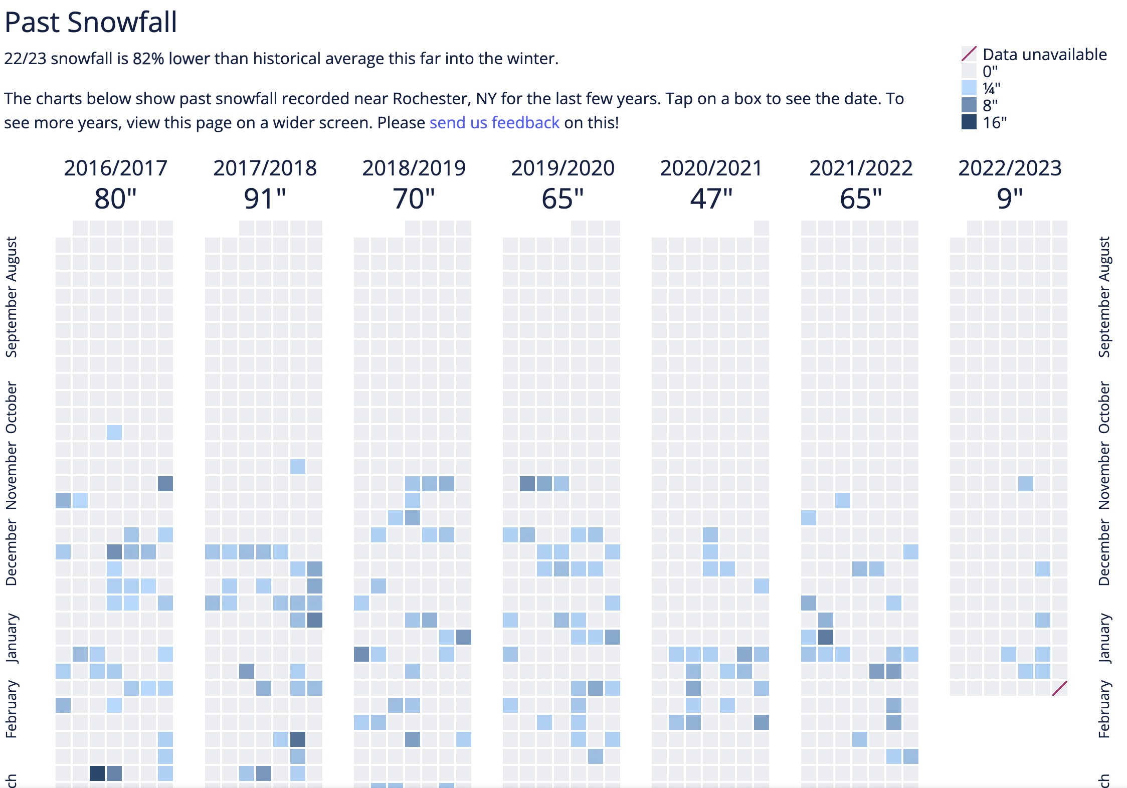
This is a very interesting post @psuhoffman. This tells me just how entrenched this current snow drought is and just how wide spread it is. I was actually a little surprised by the ~12 inch number.. thinking that there had to be other years sprinkled in that were close to this. This tells me that no one is getting snow any where, regardless of climo, elevation or latitude. I mean, its the same all the way to through New York. Look at Rochester: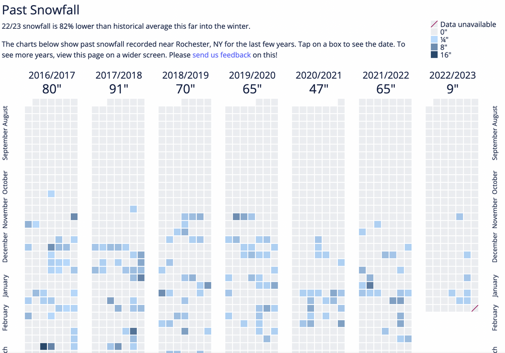
-
Late February will be rocking. February Long range Discussion thread
MDScienceTeacher replied to Ji's topic in Mid Atlantic
What does your wife do that she gets to go to the super bowl in a skybox? -
Late February will be rocking. February Long range Discussion thread
MDScienceTeacher replied to Ji's topic in Mid Atlantic
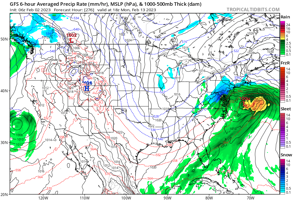
What the 12Z is showing is meteorologically impossible. There is a low pressure in SW Illinois for 3 days. That can't happen. -
Late February will be rocking. February Long range Discussion thread
MDScienceTeacher replied to Ji's topic in Mid Atlantic
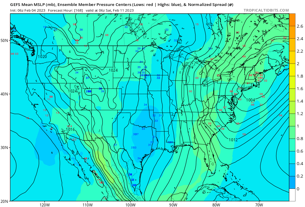
Blocking is not a full on requirement for it to snow in the MA. Do we need it for a HECS? Sure. But it snows all the time this time of the year just as it is advertised on GFS. One thing I do like is that the spread on the ensemble members show a lot of lows to our south. I think it might be having a hard time differentiating btw the first system and the second one, however the trend on the 6z was south, with a big trough digging in to the southeast part of the country.. if the 12Z runs continue that trend, we will have a nice snow storm to track. Has anyone post the ensemble member snowfall maps?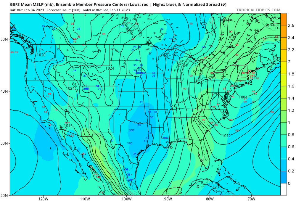
-
Late February will be rocking. February Long range Discussion thread
MDScienceTeacher replied to Ji's topic in Mid Atlantic
Me!!! -
Late February will be rocking. February Long range Discussion thread
MDScienceTeacher replied to Ji's topic in Mid Atlantic
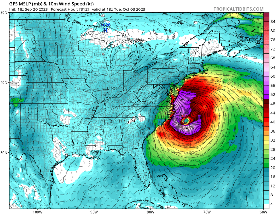
BTW... this happened: and this happened:

-
Late February will be rocking. February Long range Discussion thread
MDScienceTeacher replied to Ji's topic in Mid Atlantic
The coldest stretch in our area since 1899 was Feb 15 to Feb 20 2015. This time period featured several record low min and max temps. This demonstrates that it can still get very cold in our area. we shroud just focus on the pattern… it definitely will get a lot better for us and I would bet my house that we see a big seasonal snowfall number at some point over the next few years -
Jan 31 - Feb 1 Snow/Sleet/Misery Obs & Disco
MDScienceTeacher replied to NorthArlington101's topic in Mid Atlantic
thats fine -
January/February Mid/Long Range Disco IV: A New Hope
MDScienceTeacher replied to stormtracker's topic in Mid Atlantic
Oh haha climate change.. yeah that’s a sensitive topic… there is a lot of science out there that is pretty much undebatable. And I am pretty sure we are now seeing the outcomes first hand. It’s the find out part of it. . -
January/February Mid/Long Range Disco IV: A New Hope
MDScienceTeacher replied to stormtracker's topic in Mid Atlantic
I am sorry… but what does cc stand for? -
January/February Mid/Long Range Disco IV: A New Hope
MDScienceTeacher replied to stormtracker's topic in Mid Atlantic
I know, I know.. it right where we want it .. lol!!!! -
January/February Mid/Long Range Disco IV: A New Hope
MDScienceTeacher replied to stormtracker's topic in Mid Atlantic
Comparing the overall progression with the last run, I am pretty sure the second one is gonna be north. Look at that HP coming down out of Central Canada. Thats real deal cold. -
Me too! This is a bucket list thing for me. I feel like every year they get a 5+ foot event up there. It would be relatively easy to time it given the year to year consistency and how these events show up in the long range.. the question is whether or not they have good options for lodging in that elevation and the power.. losing power in this kind of event could be life threatening. BTW.. I actually sat next to a woman on a plane ride from Buffalo last weekend who said she got 7 feet in her back yard in one of the two big storms this year. Not sure how much she was exaggerating but thats just about as much snow your gonna see from one event any where.