MDScienceTeacher
-
Posts
332 -
Joined
-
Last visited
Content Type
Profiles
Blogs
Forums
American Weather
Media Demo
Store
Gallery
Everything posted by MDScienceTeacher
-
It we cool to see Flacco , Ray and Lamar each on stage tonight!
-
2024 Valentines Day Rain/Snow/Who The Hell Knows Thread
MDScienceTeacher replied to WinterWxLuvr's topic in Mid Atlantic
This is Definitely a trend on the euro
-
2024 Valentines Day Rain/Snow/Who The Hell Knows Thread
MDScienceTeacher replied to WinterWxLuvr's topic in Mid Atlantic
If you were in central pa the gfs and euro are pretty locked in. The only difference with the gfs is that the 850s crash a lot earlier and we get in the comma head for a few hours with some heavy/ dynamic snowfall. At this point I am thinking a day out on the slopes at liberty might be a safe bet. -
2024 Valentines Day Rain/Snow/Who The Hell Knows Thread
MDScienceTeacher replied to WinterWxLuvr's topic in Mid Atlantic
Not sure if anyone has it faster but the low is maybe 50 miles further south at 84 hours -
I am pretty sure the vast majority of that is the first storm.
-
2024 Valentines Day Rain/Snow/Who The Hell Knows Thread
MDScienceTeacher replied to WinterWxLuvr's topic in Mid Atlantic
To me it looks more like variation in the timing more then anything else. -
2024 Valentines Day Rain/Snow/Who The Hell Knows Thread
MDScienceTeacher replied to WinterWxLuvr's topic in Mid Atlantic
Not a member above the mason dixon. It is less than 5 days and it hasn’t shown a run without any snow in the ma in like 10 runs. I have never in my life seen the euro trend toward the gfs when we need it to. Maybe just maybe this will be the miracle and the euro caves here in about 30 minutes -
2024 Valentines Day Rain/Snow/Who The Hell Knows Thread
MDScienceTeacher replied to WinterWxLuvr's topic in Mid Atlantic
And we have this going for us. -
2024 Valentines Day Rain/Snow/Who The Hell Knows Thread
MDScienceTeacher replied to WinterWxLuvr's topic in Mid Atlantic
If you go back to 12z yesterday it is a huge shift in the right direction so I am happy with this. What we can’t have is the 2 meeting in the middle.. so we basically have 0 wiggle room and are relying on the euro to continue its shift. Fun times for sure. -
2024 Valentines Day Rain/Snow/Who The Hell Knows Thread
MDScienceTeacher replied to WinterWxLuvr's topic in Mid Atlantic
I would not worry about it too much. We have seen thunder snow with these types of setups in the past.. as long as we get the rates I am pretty sure the cold air aloft will mix down -
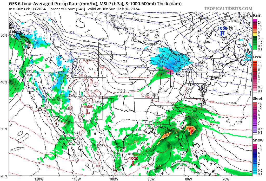
Um guys.. not sure if anyone is getting this faster.. but the GFS looks like it might go off again.. could be wrong. but that 1039 HP isnt really budging.

-
If memory serves, the first PSU storm was Dec 26 2011.
-
2024 Valentines Day Rain/Snow/Who The Hell Knows Thread
MDScienceTeacher replied to WinterWxLuvr's topic in Mid Atlantic
If the storm track and strength remains the same as what was shown on the 18z I will take my chances with the thermals. There is a lot of potential with this one.. I would not be surprised if we were looking at a warning level event heading in the to weekend. -
Me too. The last time we saw a progression like this I think it was Commutamageddon (Jan 2011). Ground temp were really warm leading up to the event too, but the developing upper level low pulled in so much cold air that the streets caved in about 10 minutes after start time. There is a lot of cold air aloft to work with.. I am hoping this one trends in the right direction.
- 2,509 replies
-
- 5
-

-
- weenie fest or weenie roast?
- weenies got roasted
- (and 2 more)
-
I think that was storm #1. A lot of people forget that every county in the state of md (except Worcester) was under a blizzard warning for the second storm… I don’t know if that will ever happen again
-
Pulitzer Prize worthy
-
It is alive and well on the euro (albeit too warm)
-
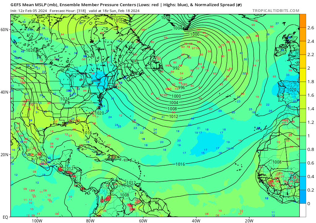
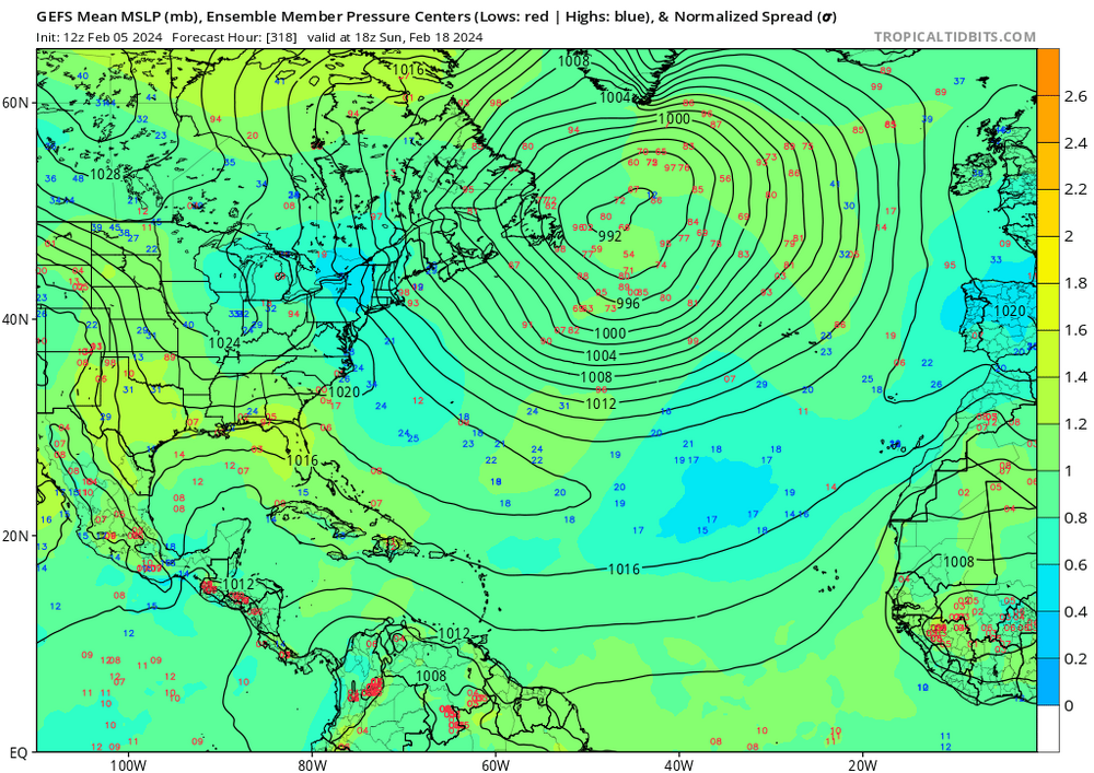
It is pretty interesting to look at the progression of the Individual members on the GEFS.. look at the confidence on the 50-50 at 318 hours..
- 2,509 replies
-
- 5
-

-
-
- weenie fest or weenie roast?
- weenies got roasted
- (and 2 more)
-
In am not criticizing. It was worth a posting and I am excited about the potential. I am just pointing out that we are in our climatological high point of our snowstorm chances and the only thing we get on the operational models is a 480 hour mega hecs
-
My nephew just called me and said.. you gotta see the extended euro. I said it’s a fake storm.. then he said.. “if stormchaserchuck is excited then I am excited”
- 2,509 replies
-
- 10
-
-
- weenie fest or weenie roast?
- weenies got roasted
- (and 2 more)
-
I can’t believe we are looking at 480 hr snow maps. This has to be a new low.
- 2,509 replies
-
- 9
-
-
-

-

-
- weenie fest or weenie roast?
- weenies got roasted
- (and 2 more)
-
Can you explain the difference with this?
- 2,509 replies
-
- 3
-
-
-
- weenie fest or weenie roast?
- weenies got roasted
- (and 2 more)
-
I would venture to say that any run of the GEFS from December to February on a 15 day lead time would show at least one good snow storm for our region Unless the majority of the members are saying the same thing, 15 days is too far out to take seriously.
- 2,509 replies
-
- 2
-
-
-
- weenie fest or weenie roast?
- weenies got roasted
- (and 2 more)
-
Jan/Early Feb Medium/Long Range Discussion Part 3
MDScienceTeacher replied to WinterWxLuvr's topic in Mid Atlantic
I see.. so probably have to wait. this time of year is rough.. when you are getting closer and closer to the end of our window and nothing is on the horizon... its hard to watch.