

MDScienceTeacher
-
Posts
332 -
Joined
-
Last visited
Content Type
Profiles
Blogs
Forums
American Weather
Media Demo
Store
Gallery
Everything posted by MDScienceTeacher
-
January Medium/Long Range: A snowy January ahead?
MDScienceTeacher replied to mappy's topic in Mid Atlantic
The GFS brought snow back for Sunday into Monday. Little further south, but at least it still had the same idea as the 18Z -
January Medium/Long Range: A snowy January ahead?
MDScienceTeacher replied to mappy's topic in Mid Atlantic
Right! It was commutageddon .. lots of cars up and down the 95 corridor were stuck for hours.. some abandoned.. I remember going out with a shovel to help dig people out. My wife thought I was crazy. https://wtop.com/weather-news/2015/01/history-disastrous-snow-storms-d-c-area/ -
January Medium/Long Range: A snowy January ahead?
MDScienceTeacher replied to mappy's topic in Mid Atlantic
You are right .. 2000 was a big January. Now I realize why I don’t remember it.. I was in the Caribbean most of the month on an Oceanographic research expedition. Getting off the plane at bwi with a beard and tan only to get a snow storm a few days later. -
January Medium/Long Range: A snowy January ahead?
MDScienceTeacher replied to mappy's topic in Mid Atlantic
One of my top 5 storms was in 2011 Big closed ull bowling ball with some of the craziest dynamic snowfalls we have ever seen. I got slammed with well over a foot of snow in less than 8 hours… Nothing sticks out for 2000… -
January Medium/Long Range: A snowy January ahead?
MDScienceTeacher replied to mappy's topic in Mid Atlantic
I know what the mjo is but I often wonder if the mjo is correlated with the monsoon in tropical regions. In otherwords, do monsoons happen in an area when the mjo is in a certain phase? -
I measured 2.6 on my truck this morning.. I am in Ellicott City by Dicks/ Giant. I was shocked... didnt expect more than 1. We must have gotten under a good band last night.
-
I got btw 2 and 3 inches in Ellicott City. Side Roads completely covered/ need plowing. Pleasantly surprised in Ellicott City.
-
January Medium/Long Range: A snowy January ahead?
MDScienceTeacher replied to mappy's topic in Mid Atlantic
2014.. they had their comutageddon https://www.ajc.com/news/atlanta-news/atlanta-snowmaggedon-2014-the-january-snow-storm-that-paralyzed-atlanta/KTEPKGS2RNHBTEOCIOFVSKNWFE/ -
January Medium/Long Range: A snowy January ahead?
MDScienceTeacher replied to mappy's topic in Mid Atlantic
But it basically shows what the gfs and euro are showing -
January Medium/Long Range: A snowy January ahead?
MDScienceTeacher replied to mappy's topic in Mid Atlantic
Based on the ensemble trends (thanks @brooklynwx99), It looks to me that a storm will strengthen and ride up underneath the block. The question now is whether or not it can gets its act together before it passes us. -
I have 4 inches in Ellicott City and it is still snowing. It is definitely not a bust. Unless you took the best 3 model runs over the last 5 days and thought you were getting a foot.
-
January Medium/Long Range: A snowy January ahead?
MDScienceTeacher replied to mappy's topic in Mid Atlantic
I have never seen a map like that. Not even in 2016 -
I don’t think tv stations have numerical predictions models or super computers.. but maybe
-
lol I didn’t realize it was that close… I know you are down in sw Virginia now but even so the ob took me by surprise. I really hope the column holds for you and you do well! Good luck.
-
It is actually quite amazing how stubbornly different they all are. I guess we just take a blend and everyone is happy.
-
No. The 2016 Blizzard featured 3 inch per hour rates for 3 hours IMBY. That 0.5-0.6" QP in 6 hours is 1 inch per hour.
-
These comparisons are not really showing any significant shifts at all IMHO. Especially the Euro. It hasnt really changed at all in the last 3 days.
-
If the ccb gets cranking with the ull passage, then there is a big chance for 10+ inch totals somewhere in our forum. A few years ago I remember an event where Rockville got in toto backside banding and it snowed and extra 6 inches in a small concentrated area. I feel like that could happen again with this storm. The gfs has hinted towards it a couple of times in the last few runs.
-
Ughhh that’s the kiss of death. I honestly would have preferred that had shown a Richmond bullseye.
-
January: Medium/ Long Range: May the Force be with Us....
MDScienceTeacher replied to Weather Will's topic in Mid Atlantic
It’s not a guarantee. You have to look at the upper level flow. This is the 500mb height anomaly at the time the storm is approaching our area. Notice the sw to ne lines flowing directly over the mid Atlantic and the large low pressure over the Canadian maritimes. This is the main feature that will determine the storm track. If that feature is not there, then I would agree that we would see the typical north shift with the gfs as we approach game time. But since this feature is so dominant in this set up.. you have to at least give the gfs some credence with the suppressed/ southern look.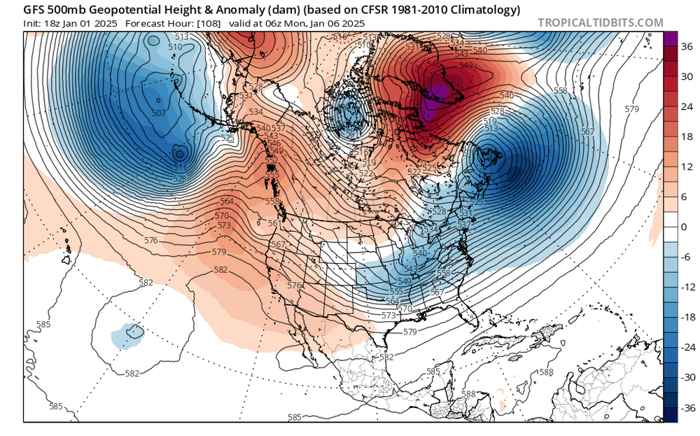
-
January: Medium/ Long Range: May the Force be with Us....
MDScienceTeacher replied to Weather Will's topic in Mid Atlantic
Exactly -
January: Medium/ Long Range: May the Force be with Us....
MDScienceTeacher replied to Weather Will's topic in Mid Atlantic
Are you doing the pbp again? -
January: Medium/ Long Range: May the Force be with Us....
MDScienceTeacher replied to Weather Will's topic in Mid Atlantic
Regardless of the southern solutions.. I would be shocked if northern md wasn’t once again in the jack pot. -
January: Medium/ Long Range: May the Force be with Us....
MDScienceTeacher replied to Weather Will's topic in Mid Atlantic
It already is a real threat. The euro at 120 hours is basically in its wheelhouse. -
January: Medium/ Long Range: May the Force be with Us....
MDScienceTeacher replied to Weather Will's topic in Mid Atlantic
yes.. both of those storms featured very cold/ high ratio snow. I am pretty sure it was low-mid 20.


