MDScienceTeacher
-
Posts
332 -
Joined
-
Last visited
Content Type
Profiles
Blogs
Forums
American Weather
Media Demo
Store
Gallery
Everything posted by MDScienceTeacher
-
January 2026 Medium/Long Range Discussion
MDScienceTeacher replied to snowfan's topic in Mid Atlantic
#BigOnesAreSniffedOutEarly -
January 2026 Medium/Long Range Discussion
MDScienceTeacher replied to snowfan's topic in Mid Atlantic
this is cm right? -
January 2026 Medium/Long Range Discussion
MDScienceTeacher replied to snowfan's topic in Mid Atlantic
We aren’t going to get more snow this year, are we? These models make me so sad. -
January 2026 Medium/Long Range Discussion
MDScienceTeacher replied to snowfan's topic in Mid Atlantic
Jan 2011 too -
January 2026 Medium/Long Range Discussion
MDScienceTeacher replied to snowfan's topic in Mid Atlantic
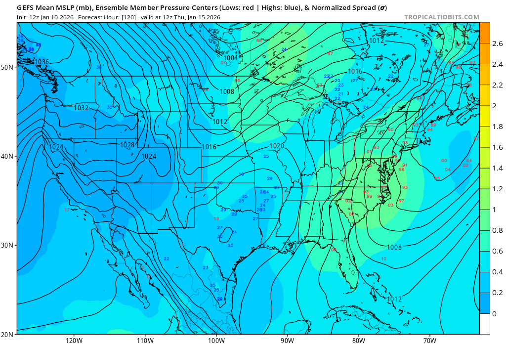
Yeah I guess. In all honesty I hadn’t seen the euro when I posted this. If I had and saw the favorable trend I probably wouldn’t have posted this. Even at hr 120 we are still in a progressive flow so I guess it makes sense for the ensembles to be in so far apart. In past events we have seen much more agreement but in almost all of those cases we have had a favorable Atlantic. -
January 2026 Medium/Long Range Discussion
MDScienceTeacher replied to snowfan's topic in Mid Atlantic
I mean the individual members couldn’t be further apart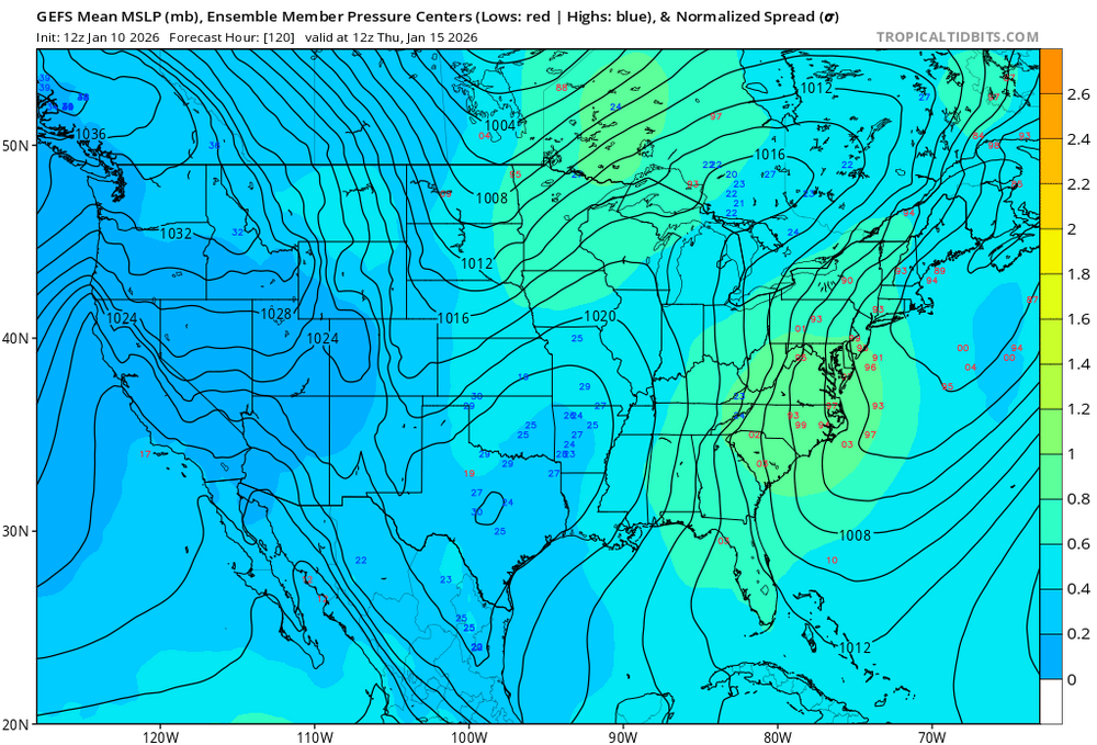
-
January 2026 Medium/Long Range Discussion
MDScienceTeacher replied to snowfan's topic in Mid Atlantic
I preferred TT because I though that Pivotal didnt have the slider animation feature.. but I realized just a couple of weeks ago that you can set Pivotal to the slider by choosing animation -> forecast loop at the top of the map. -
12/14: Sunday funday? Will the south win again?
MDScienceTeacher replied to TSSN+'s topic in Mid Atlantic
This is the coldest it’s been leading up to any snow event since maybe 10 years as far as I can remember -
12/14: Sunday funday? Will the south win again?
MDScienceTeacher replied to TSSN+'s topic in Mid Atlantic
I’m gonna go out in a limb here and say the precipitation type is not gonna be an issue except maybe for the first half an hour -
12/14: Sunday funday? Will the south win again?
MDScienceTeacher replied to TSSN+'s topic in Mid Atlantic
Yeah I have seen this for snow squalls situations where they are only expecting 2-4 inches -
12/14: Sunday funday? Will the south win again?
MDScienceTeacher replied to TSSN+'s topic in Mid Atlantic
I like @Terpeastforecast a lot better at least he makes an actual forecast. This is just “I’m gonna make a map that could cover any possible outcome.” -
12/14: Sunday funday? Will the south win again?
MDScienceTeacher replied to TSSN+'s topic in Mid Atlantic
Maybe it was an icing situation I am thinking about. Which would make more sense. -
12/14: Sunday funday? Will the south win again?
MDScienceTeacher replied to TSSN+'s topic in Mid Atlantic
Actually, no, I’ve seen a warning for a 2 to 4 inch so I think they take into consideration overall conditions, especially if there is a chance for dynamic snow that’s gonna take people by surprise -
12/14: Sunday funday? Will the south win again?
MDScienceTeacher replied to TSSN+'s topic in Mid Atlantic
I don’t understand why this is not a warning for Carrol, Baltimore, Harford counties. With the cold air mass in place and the possibility for moderate to heavy snow over a short period of time roads will be extremely bad. -
12/14: Sunday funday? Will the south win again?
MDScienceTeacher replied to TSSN+'s topic in Mid Atlantic
I have a house in Rehoboth and an apartment in Elliott city. This is gonna happen.. 100% just like this. because the snow gods hate me and my family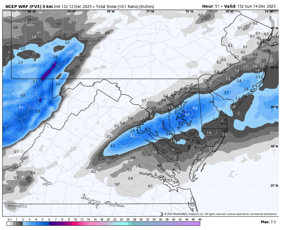
-
I agree. Btw this event reminds me of one of the events we had in 2015.. I think it was the Valentine’s Day snow squalls. that event was modeled as snow showers right up until the short range models started picking up on squall lines and coastal development. I remember some places in Hartford county seeing 4-6 inches in a very short period of time. the official Bwi total was 2.5 inches. here is a link to foots forecast for that storm. I couldn’t find much on it.. others than this https://www.facebook.com/ffcentralmaryland/photos/730-am-214-something-wicked-this-way-comes-and-we-hope-you-are-well-aware-of-the/10152687024933857/?http_ref=eyJ0cyI6MTc2NTQ1Nzk1ODAwMCwiciI6Imh0dHBzOlwvXC93d3cuZ29vZ2xlLmNvbVwvIn0%3D
-
I have zero scientific reason for this statement, but this is going improve as we get closer and will over perform at game time. 2014-2015 style!
-
Why not?? I have a house down in rehoboth and we have seen more snow down there than in Elliott City the last 2 out of 3 winters. One year (I think 21-22) was one of the snowiest seasons they have seen in a very long time. It’s looking like that seasonal pattern is setting up again. the problem is clearly not cold air. It’s timing, overall precip and storm track. This is why it’s so frustrating when I have a normal person tell me “it just doesn’t snow like it used to, it’s doesnt get cold enough anymore”
-
If you look at ensemble members at this range during a time period where there is possible threat, they will inevitably show solutions like the one shown on that infamous 6Z run from last Wednesday. Nobody ever takes that a random ensemble member seriously at that range. But when the op shows it, people hold out hope, even if it never shows up again. I dont understand why people never learn.
-
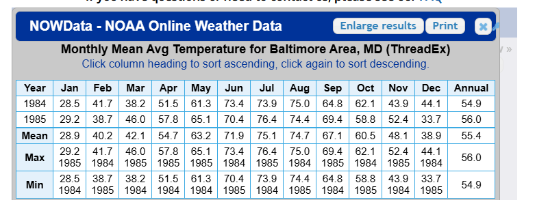
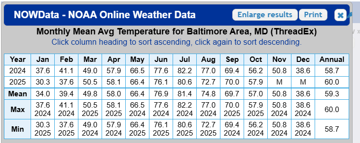
So January was in the top 40 of all time: Looking at the January temperature data from 1871-2025, here are the top 40 coldest Januaries on record (from coldest to warmest): | Rank | Year | January Temp (°F) | |------|------|-------------------| | 1 | 1977 | 22.9 | | 2 | 1893 | 23.5 | | 3 | 1918 | 24.2 | | 4 | 1982 | 25.5 | | 5 | 1912 | 25.8 | | 6 | 1940 | 26.0 | | 7 | 1994 | 27.1 | | 8 | 1904 | 27.4 | | 9 | 2014 | 27.4 | | 10 | 1961 | 27.6 | | 11 | 2004 | 27.6 | | 12 | 1970 | 27.8 | | 13 | 1981 | 27.9 | | 14 | 2003 | 28.3 | | 15 | 1984 | 28.5 | | 16 | 1988 | 28.7 | | 17 | 1963 | 28.8 | | 18 | 1920 | 28.6 | | 19 | 1958 | 32.4 | | 20 | 1875 | 29.4 | | 21 | 1886 | 29.4 | | 22 | 1877 | 29.9 | | 23 | 1985 | 29.3 | | 24 | 2009 | 29.3 | | 25 | 1888 | 29.7 | | 26 | 1881 | 29.6 | | 27 | 1968 | 29.2 | | 28 | 1978 | 29.2 | | 29 | 1948 | 29.3 | | 30 | 1966 | 29.8 | | 31 | 1871 | 35.3 | | 32 | 1957 | 30.3 | | 33 | 2011 | 30.3 | | 34 | 2025 | 30.3 | | 35 | 1971 | 30.0 | | 36 | 1905 | 30.8 | | 37 | 1976 | 30.8 | | 38 | 2015 | 30.8 | | 39 | 1965 | 30.8 | | 40 | 1936 | 30.8 | After reviewing the data more carefully, here are the top 80 coldest winter seasons properly sorted from coldest to warmest: | Rank | Season | DJF Average (°F) | |------|-----------|------------------| | 1 | 1962-1963 | 29.2 | | 2 | 1903-1904 | 29.7 | | 3 | 1904-1905 | 29.9 | | 4 | 1917-1918 | 30.0 | | 5 | 1976-1977 | 30.7 | | 6 | 1977-1978 | 30.7 | | 7 | 1960-1961 | 31.0 | | 8 | 1875-1876 | 31.0 | | 9 | 1936-1937 | 31.1 | | 10 | 1919-1920 | 31.5 | | 11 | 1880-1881 | 31.6 | | 12 | 1895-1896 | 31.6 | | 13 | 1981-1982 | 31.9 | | 14 | 1876-1877 | 32.1 | | 15 | 1892-1893 | 32.1 | | 16 | 1965-1966 | 32.1 | | 17 | 1894-1895 | 32.3 | | 18 | 1890-1891 | 32.3 | | 19 | 1901-1902 | 32.4 | | 20 | 1993-1994 | 32.4 | | 21 | 1958-1959 | 32.5 | | 22 | 1959-1960 | 32.5 | | 23 | 2014-2015 | 32.5 | | 24 | 1898-1899 | 32.7 | | 25 | 1961-1962 | 32.7 | | 26 | 1877-1878 | 32.9 | | 27 | 1879-1880 | 32.9 | | 28 | 1911-1912 | 32.9 | | 29 | 1964-1965 | 32.9 | | 30 | 1967-1968 | 32.9 | | 31 | 1935-1936 | 33.0 | | 32 | 1888-1889 | 33.0 | | 33 | 1872-1873 | 33.2 | | 34 | 1963-1964 | 33.3 | | 35 | 1985-1986 | 33.3 | | 36 | 1970-1971 | 33.6 | | 37 | 1883-1884 | 33.6 | | 38 | 1999-2000 | 33.6 | | 39 | 1968-1969 | 33.7 | | 40 | 1881-1882 | 33.7 | | 41 | 1884-1885 | 33.7 | | 42 | 1933-1934 | 33.8 | | 43 | 1909-1910 | 34.0 | | 44 | 1980-1981 | 34.1 | | 45 | 1955-1956 | 34.2 | | 46 | 1966-1967 | 34.5 | | 47 | 1916-1917 | 34.5 | | 48 | 1906-1907 | 34.5 | | 49 | 1939-1940 | 34.7 | | 50 | 1986-1987 | 34.7 | | 51 | 1987-1988 | 34.8 | | 52 | 1950-1951 | 35.0 | | 53 | 2008-2009 | 35.1 | | 54 | 2024-2025 | 35.5 So definitely not the anywhere near coldest of all time, but somewhere around 80th percentile given ~200 years of data.
-
Right.. I dont understand the comments above. It was one of the coldest winters of all time. See above. 13 through 14 and 14 through 15 we’re definitely one of the coldest on record. but last year compared to others, was one of the coldest years. What is interesting however is that we’ve had some of the coldest winters on record in the last 25 years. It’s almost as if winters are becoming more severe and more cold. 24-25 38.6, 30.3, 37.6 13-14 39.6 27.4 32.9 14-15 39.9, 30.8, 25.3
-
I had an argument with several people about this over the weekend. Every single person said last winter was warm. For some reason LLMs seem to be bias on this also saying that 84-85 was much colder and that last year was only "Mildly Cold". I thought last year was one of the coldest on record. Based on NOAA data it was right up there with 84-85:
-
I am sorry.. i see that there are some rules around this now.. I should have known. I am gonna get away from the computer for a while and get some exercise. Let’s see what happens later today
-
Thats the point I am trying to make.. there is a precedent for this fail mode.. my apologies for the graphic. I can take it down.
-
It is important that people understand how things work here wrt to snow.