MDScienceTeacher
-
Posts
332 -
Joined
-
Last visited
Content Type
Profiles
Blogs
Forums
American Weather
Media Demo
Store
Gallery
Everything posted by MDScienceTeacher
-
this happens every time when we are waiting for it to start to snow. For some reason people start to panic and think that it is over before it starts
-
A snow day is a snow day. It is sacred in my opinion and shall not be infringed upon. Even if the technology is available for virtual alternatives.
-
February 11-12; 12-13: Are they real??
MDScienceTeacher replied to stormtracker's topic in Mid Atlantic
Thank you! I was getting annoyed with the all the over cautiousness/ conservatism wrt to the total potential for this storm. Everyone seems to be stuck on 3-6/ 2-4 amounts. I think that It won’t take much to push this over 8 inches. So why not go all in? -
February 11-12; 12-13: Are they real??
MDScienceTeacher replied to stormtracker's topic in Mid Atlantic
This takes melting/ surface temperatures/ rates etc into consideration. A lot of people say that it is more useful than the regular total snowfall. I am convinced that Tt counts cold rain as snow for in total snowfall maps.. so positive snow depth is probably more reliable. -
February 11-12; 12-13: Are they real??
MDScienceTeacher replied to stormtracker's topic in Mid Atlantic
That would do it -
February 11-12; 12-13: Are they real??
MDScienceTeacher replied to stormtracker's topic in Mid Atlantic
I was never buying it and if it did show .75 inches qpf over 24 hours I would think that a lot of that is lost to melting especially during the day time. I would much rather see .4 inches in a 6 hour period than .75 over 24 hours. -
February 11-12; 12-13: Are they real??
MDScienceTeacher replied to stormtracker's topic in Mid Atlantic
Where do I sign? -
February 11-12; 12-13: Are they real??
MDScienceTeacher replied to stormtracker's topic in Mid Atlantic
I don’t think Baltimore city did as well… maybe 4-5 inches max -
February 11-12; 12-13: Are they real??
MDScienceTeacher replied to stormtracker's topic in Mid Atlantic
Yeah there was a band that set up over bwi and extended back in to Catonsville/ Elliott city . I got 7.5 (5 for the first part and 2.5 for the second part) which was more than I expected. -
February 11-12; 12-13: Are they real??
MDScienceTeacher replied to stormtracker's topic in Mid Atlantic
That’s one of the things that normies don’t understand. Most people I know are convinced that it just doesn’t snow around here any more.. I even saw a snowblower out there other day with a “free” sign on it. When I tell them that it has snowed plenty areas just to our south they look at me with confusion because in their mind snow is a thing of the past and entertaining the possibility that a lot of snow storms may have missed to our south is preposterous. -
February 11-12; 12-13: Are they real??
MDScienceTeacher replied to stormtracker's topic in Mid Atlantic
Oh.. I didnt realize that its him... I thought he moved away or something. -
February 11-12; 12-13: Are they real??
MDScienceTeacher replied to stormtracker's topic in Mid Atlantic
the issue is that big 1043 HP settling down out out of Canada. It is such a double edge sword. we need the cold air, but just enough not to suppress the wave.
-
February 11-12; 12-13: Are they real??
MDScienceTeacher replied to stormtracker's topic in Mid Atlantic
Not sure if this will happen this time, but I remember set ups like this ending up wetter/ picking up more gulf moisture. -
February 11-12; 12-13: Are they real??
MDScienceTeacher replied to stormtracker's topic in Mid Atlantic
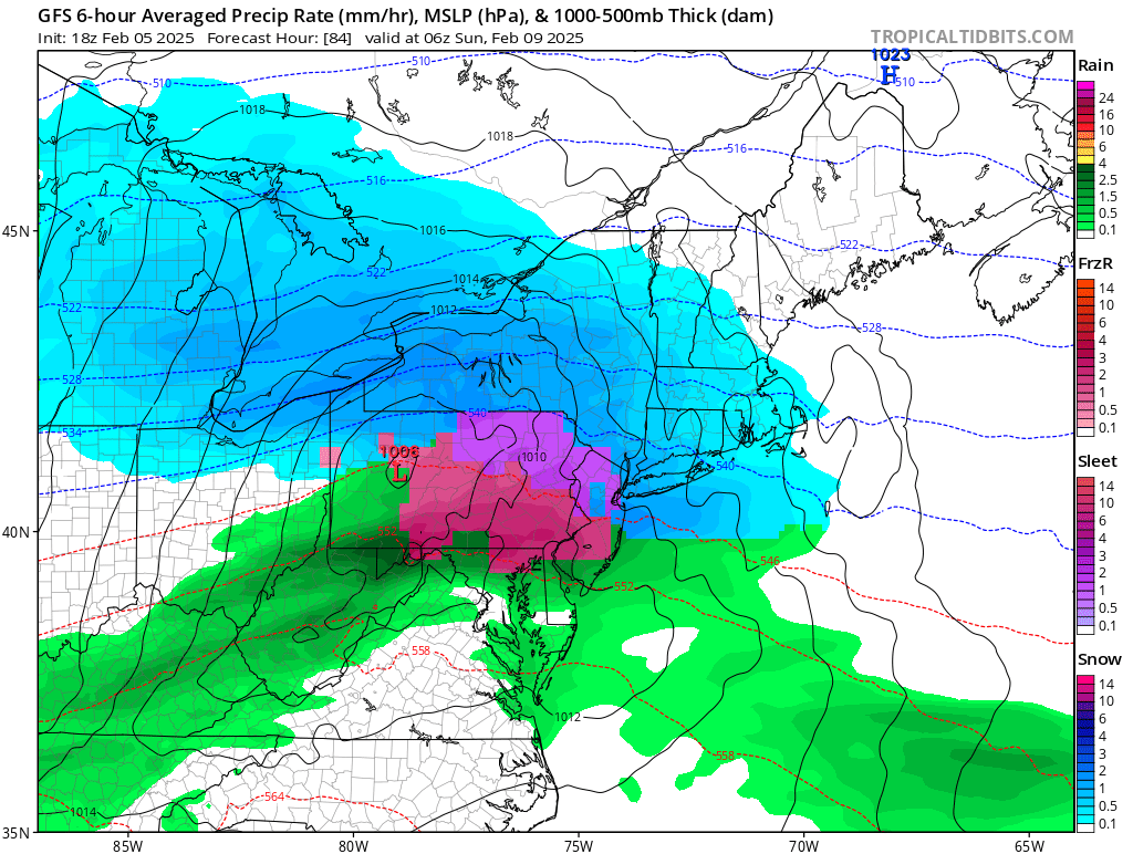
If this holds and it verifies just a little wetter/ more amped (and the surface temps stay cold enough for accumulation), it will be a warning level event for DC. -
February 11-12; 12-13: Are they real??
MDScienceTeacher replied to stormtracker's topic in Mid Atlantic
I thought the 6Z gave DC like 5 inches? -
February 11-12; 12-13: Are they real??
MDScienceTeacher replied to stormtracker's topic in Mid Atlantic
Are those dropsondes routine or do they only drop them during times of particularly active weather? -
February 11-12; 12-13: Are they real??
MDScienceTeacher replied to stormtracker's topic in Mid Atlantic
Holy Fuck -
February 11-12; 12-13: Are they real??
MDScienceTeacher replied to stormtracker's topic in Mid Atlantic
I had 7.5 and that was my high water mark since 2016. -
February 11-12; 12-13: Are they real??
MDScienceTeacher replied to stormtracker's topic in Mid Atlantic
IDK. The models have consistently shown a long duration moderate snow event for our area for the past 5 days. On the GFS, The 24 hour QPF totals have been btw 1 and 1.5 in the bullseye areas. Although its not HECs worthy, I feel like there is a little more boom potential. -
Yeah I dont care if it is upper air/ long wave/ ensemble mean .. I just dont take anything serious outside of 180 hours... I just dont have the knowledge to take what the computer model is spitting out seriously. I am sure @psuhoffman does, so I will trust him. My kids watch a lot of weather youtube and there are guys who will literally step through every frame of the CFS out to six weeks and talk about it as if it is a forecast. Its a real disservice and not the intended use of those models.
-
The fact that this accounts for the first 7 inches in Baltimore completely calls the entire TT snow map calculation in to question.

-
What was similar was the run to run consistency and the global model agreement. Even if all of the ingredients werent actually on the table, the event certainly seemed to be one of those that lock in early and never waiver. Lets just hope this is the mid range slippage and things get back on track shortly.
-
We never get blend when we need the blend. More often than not one model is right and the other is wrong and we watch painstakingly as one moves toward the other. Can we please just get a blend here the one time?
-
I know it doesnt work this way, but t way I look at is every year we dont get a HECS.. the higher the chances the next year. It is Weenie statistics.
-
I mean it is almost like clock work. 83, 93, 96, 03, 10, 16, 2?