Stormchaserchuck1
-
Posts
4,687 -
Joined
-
Last visited
Content Type
Profiles
Blogs
Forums
American Weather
Media Demo
Store
Gallery
Everything posted by Stormchaserchuck1
-

El Nino 2023-2024
Stormchaserchuck1 replied to George001's topic in Weather Forecasting and Discussion
The AN factor is a very positive NAO and AO (approaching +3), with +EPO being a factor some of the time too. Those are dominating, but the PNA is not part of that equation right now. -
Jan/Early Feb Medium/Long Range Discussion Part 3
Stormchaserchuck1 replied to WinterWxLuvr's topic in Mid Atlantic
In this example, the +NAO is a warm variable, yes. In the 3-5" snowfall, -NAO was a factor too, yes. Let's see if the +PNA/-EPO/+NAO and -PNA/+EPO/-NAO correlates in February.. the pattern is about 0.40 (+40% of the time) together in the last 5-11 years. And I see a high probability for this to happen next month. -
Would you bet against +PNA February?
Stormchaserchuck1 replied to Stormchaserchuck1's topic in Mid Atlantic
+PNA models have is extreme. I would bet against it.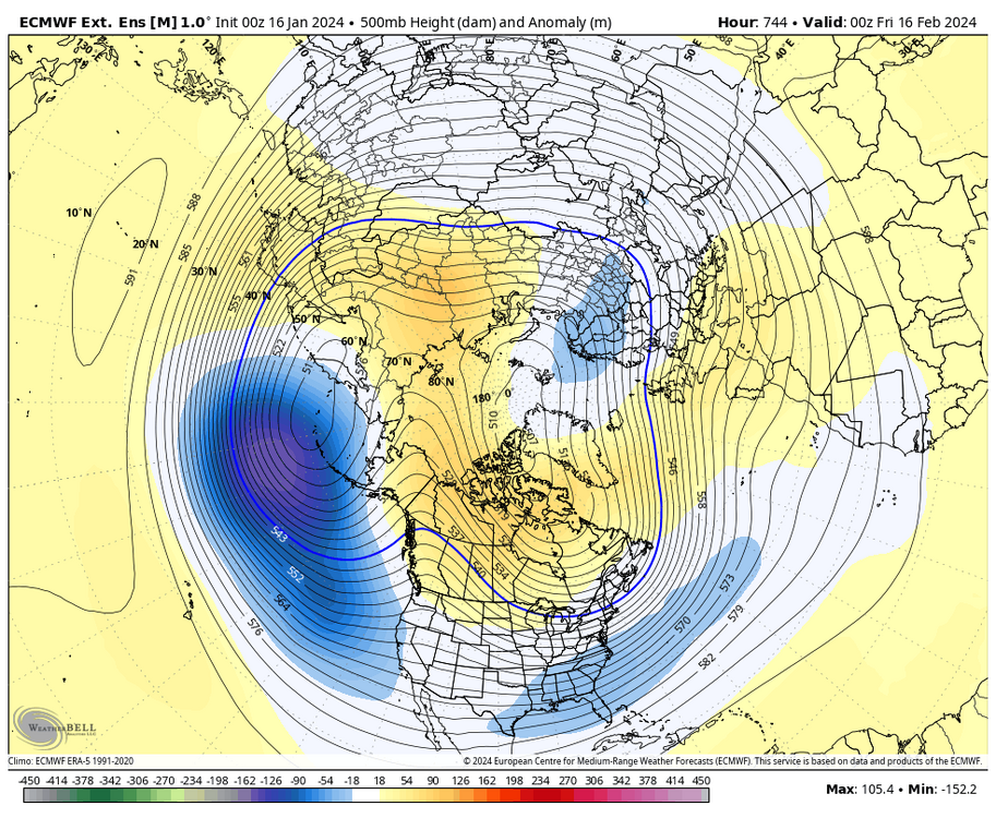
-
Jan Medium/Long Range Disco 2: Total Obliteration is Coming
Stormchaserchuck1 replied to Jebman's topic in Mid Atlantic
We should be fine by early February. There is a Stratosphere warming happening now https://ibb.co/59rRrb2 My issue is after the coldest day of the year Jan 27th, we have recently had a tendency to warm up real fast, especially in late February. -
El Nino 2023-2024
Stormchaserchuck1 replied to George001's topic in Weather Forecasting and Discussion
The southern part of the -NAO has been missing.. 50/50 low and N. Atlantic trough. There have been a lot of years where there was ridging over Greenland, and it was determined to be a neutral or positive NAO. Your stat seems impressive for the EC, but cold/warm there is part of the bottom half of the NAO calculation I think. -
Jan 15-16 Storm Thread 3: Obs and Disco
Stormchaserchuck1 replied to stormtracker's topic in Mid Atlantic
Back to light snow.. it's been going back and forth. A lot of models had it ending, or dryslotting between 1-2am so I'm glad it's still snowing to the west of DC.. -
Jan 15-16 Storm Thread 3: Obs and Disco
Stormchaserchuck1 replied to stormtracker's topic in Mid Atlantic
Moderate snow here for the last 15 minutes, bigger flakes. 4" total. It looks like radar is backbuilding still! Both the 6z Hrr and RAP had no more than 1/2" to southern PA.. edit: tiny, nice flakes again. lots of them! The coastal must be developing. -
Jan 15-16 Storm Thread 3: Obs and Disco
Stormchaserchuck1 replied to stormtracker's topic in Mid Atlantic
Nice band coming for DC! I like how the radar looks.. a few models had less activity in the south part of the band right now. 05z Hrr has less than 1" more here.. I don't know about that.. -
Jan 15-16 Storm Thread 3: Obs and Disco
Stormchaserchuck1 replied to stormtracker's topic in Mid Atlantic
My 9th grade science teacher referred me to DT who posted on Wright-weather. That was in 2001. -
Jan 15-16 Storm Thread 3: Obs and Disco
Stormchaserchuck1 replied to stormtracker's topic in Mid Atlantic
Snow pretty good again here, nice small dendrites. It was lite for the last 45 minutes, now started picking up again -
Jan 15-16 Storm Thread 3: Obs and Disco
Stormchaserchuck1 replied to stormtracker's topic in Mid Atlantic
Congrats! I think I'm over 3" here -
Jan 15-16 Storm Thread 3: Obs and Disco
Stormchaserchuck1 replied to stormtracker's topic in Mid Atlantic
Surprised.. models were all over this yesterday. They upped the totals in TN way up, and were going more negative with the trough. All you had to do is see what they were doing with everything vs reading the output totals verbatim. LWX did well I think, although they could have issued WSW's yesterday when it looked like the coastal was going to become stronger. -
Jan 15-16 Storm Thread 3: Obs and Disco
Stormchaserchuck1 replied to stormtracker's topic in Mid Atlantic
Actually nice to see the radar filling in near Harrisonburg -
El Nino 2023-2024
Stormchaserchuck1 replied to George001's topic in Weather Forecasting and Discussion
I don't agree with this.. there is a +3 day-0 correlation, then it drops down to near 0, then it goes up to +10 at day+20 (20 days after 10mb warming). If the events saw a -NAO during initial warming didn't make a difference in the eventual lagged event. The correlation isn't perfect, but it's about 65-70% of time, indifferent to what happens at D+0. -
Do you know the Ravens ended up playing only 3 teams that finished the season under .500.
-
Jan 15-16 Storm Thread 3: Obs and Disco
Stormchaserchuck1 replied to stormtracker's topic in Mid Atlantic
I have good flakes here in Harford Co. Will probably end up with 5-7". -
Jan 15-16 Storm Thread 3: Obs and Disco
Stormchaserchuck1 replied to stormtracker's topic in Mid Atlantic
GFS has some pretty moderate snow in northern MD tomm late morning/early afternoon -
Jan Medium/Long Range Disco 2: Total Obliteration is Coming
Stormchaserchuck1 replied to Jebman's topic in Mid Atlantic
That one's not going to overperform like this one did. It's really a matter of temps, when we are marginal we don't overperform.. it's pretty simple. -
Jan 15-16 Storm Thread 3: Obs and Disco
Stormchaserchuck1 replied to stormtracker's topic in Mid Atlantic
I have about 2.5". Looks like another 2-3" on the way in the next few hours here. Then we'll see if the coastal can give something extra. -
Jan Medium/Long Range Disco 2: Total Obliteration is Coming
Stormchaserchuck1 replied to Jebman's topic in Mid Atlantic
Whole pattern is changing pretty fast at that point though. It looks like they want to reload the cold given by -WPO block. With the block retrograding and not reloading at that point though, it may not verify as cold as they currently have. -
Jan 15-16 Storm Thread 3: Obs and Disco
Stormchaserchuck1 replied to stormtracker's topic in Mid Atlantic
Really gets going in NE MD. RAP has been showing this for several straight runs.. we'll see. 25F -
Would you bet against +PNA February?
Stormchaserchuck1 replied to Stormchaserchuck1's topic in Mid Atlantic
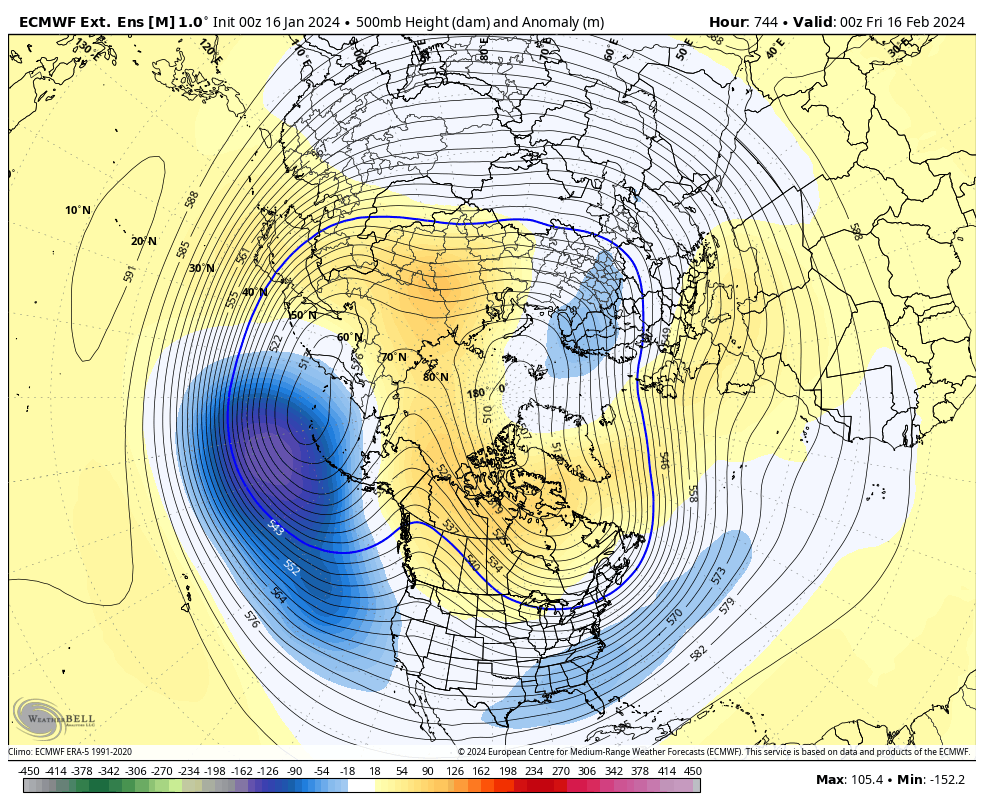
Here's what they are showing for February.. and have been showing this for a while. since at least September. Other global models are showing the same thing in the PNA region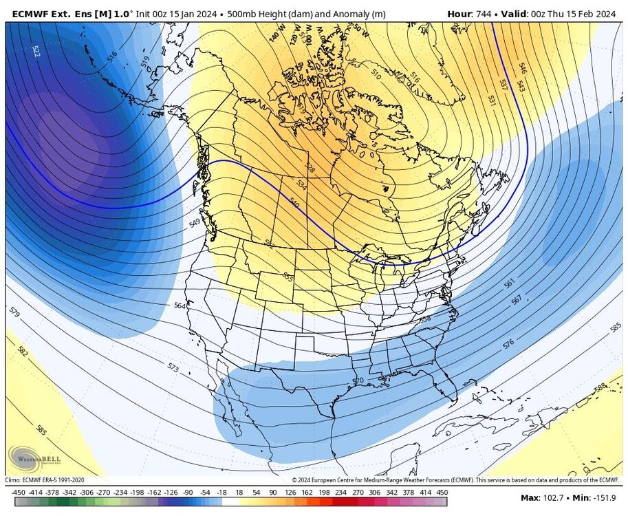
-
Jan Medium/Long Range Disco 2: Total Obliteration is Coming
Stormchaserchuck1 replied to Jebman's topic in Mid Atlantic
That storm could trend warmer. Cold air will be cutoff, with NAO going + and -WPO retrograding -
Jan 15-16 Storm Thread 3: Obs and Disco
Stormchaserchuck1 replied to stormtracker's topic in Mid Atlantic
Looks like about 1" so far in Fallston, MD. Coming down heavier now. -
Jan 15-16 Storm Thread 3: Obs and Disco
Stormchaserchuck1 replied to stormtracker's topic in Mid Atlantic
Really became a storm NW of Philly and NYC. I don't think the NW trend is over this year.. even the next weekend storm might end up pretty near freezing.