

vortmax
-
Posts
4,641 -
Joined
-
Last visited
Content Type
Profiles
Blogs
Forums
American Weather
Media Demo
Store
Gallery
Posts posted by vortmax
-
-
5 minutes ago, lakeeffectkid383 said:
Yep S+ here right now despite rather weak returns on radar. Prob 1-2”/hr stuff.

-
 2
2
-
-
Looks like Charlotte getting hammered now. My brother in West Webster got 2" from the meso.

-
3
-
-
19 minutes ago, rochesterdave said:
Not really. Snow shower at my house.
It just east. Bay bridge and West Webster.
-
 1
1
-
-
8 minutes ago, tim123 said:
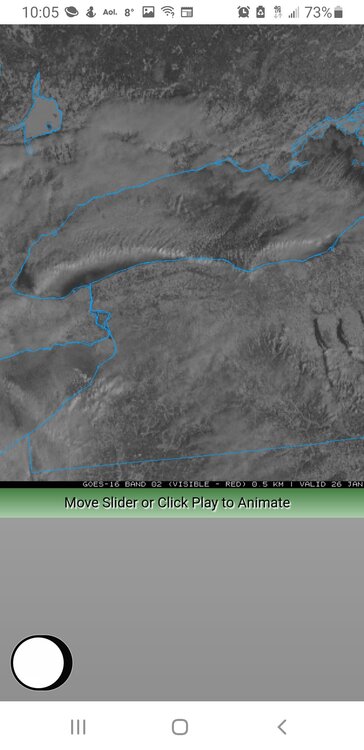
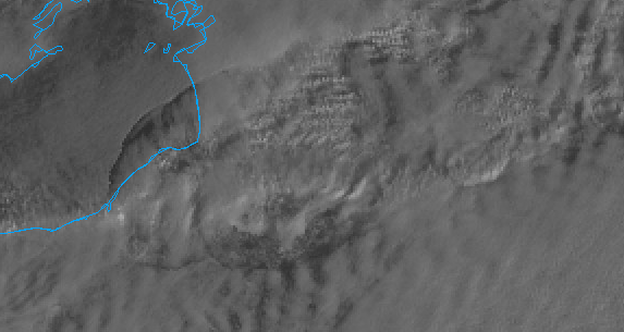
Cool sat pic this am. Looks like 2 meso lows one over niagara region one near rochester.
Wow, check out the webcam on the bay bridge:
-
Great read from ALY AFD:
.LONG TERM /THURSDAY NIGHT THROUGH TUESDAY/...
Main story for the long term is a strong coastal storm that may
impact the region Friday night into Saturday. At this time,
there is high confidence that a storm will develop, but low
confidence as to the track. While there is the potential for a
major storm for somewhere in the northeast, considerable
uncertainty in the storm track means that impacts to our
forecast area remain uncertain as well. It is too early to
estimate snowfall amounts, but will include a full analysis of
current thinking and sources of uncertainty below...

At 00z Saturday, long term begins with a large upper trough
extending from Canada down to the Gulf Coast moving across the
eastern third of the country. As this trough moves eastward Friday
night and Saturday, it will become neutrally to negatively tilted,
and surface cyclogenesis will take place off the U.S. east coast. As
this storm tracks northeastward, it is expected to rapidly deepen,
and may undergo bombogenesis (drop in central pressure of 24 mb in
24 hrs). With ample cold air in place, expecting precipitation to
fall as all snow for our region. Also, it will become breezy due to
a tight pressure gradient over the region, with some sources of
guidance suggesting the central pressure of the storm deepens into
the 960-970 mb range. Snow may begin as early as late Friday
afternoon and last into Saturday night, with the highest chance for
snow during the day Saturday.

While confidence is high in an impactful storm somewhere along the
east coast, there are several sources of uncertainty in the storm
track and therefore impacts to our region. One major source of
uncertainty is the degree of phasing on Friday between a northern
stream disturbance diving south from Manitoba and a southern stream
disturbance over Texas and New Mexico. At this time, it appears the
norther stream disturbance will take a favorable track for these
disturbances to phase, but there are more questions surrounding the
southern stream. The GFS is stronger and further to the southwest
with the souther stream disturbance, resulting in a later phase/less
phasing between the two disturbances. The result is a more
positively tilted and progressive upper trough and a storm track
further to the east. The Euro, on the other hand, has a weaker
southern stream disturbance that does not dig as far south and west.
This allows the southern stream disturbance to move out ahead of the
norther stream wave Friday and Friday night. The result is a more
negatively tilted upper trough and a storm track further to the
west. The Euro has held steady over the past few runs, while the GFS
has trended towards the Euro each of the past three runs after the
18z GFS yesterday was much further east with the storm track.

To add even more uncertainty to the forecast, Stony Brook
Sensitivity analysis developed through CSTAR research suggests that
the eventual track of the storm will also be sensitive to the
strength of the upper ridge that develops downstream of the trough
(as is usually the case with these large east coast storms). A
stronger ridge will be associated with a storm track further to the
west; this is seen in the Euro solution as well. Often, but not
always, models underestimate the strength of the downstream ridge in
the medium-range as they cannot resolve the diabatic ridge-building
due to latent heat release. With ample moisture from the Gulf of
Mexico, it is certainly possible that this trend will manifest
itself with this storm as well. Will note at this time that both the
GEFS and EPS have a subset of ensemble members tucked in closer to
the coast than the operational models suggest, suggesting that a
track further north and west remains possible. Finally, right
entrance region of an  upper jet over our region and the fact that
banded snowfall on the northwestern side of major east coast
cyclones often occurs further north and west than modeled, there is
still the potential for a precipitation shield that extends further
to the west than guidance shows. Therefore, accumulating snow is
possible further west than modeled, even with the eastern storm
track. Hopefully, will be able to gain more insights into possible
solutions by comparing model guidance to RAOB observations over the
next 24 hours as upper energy comes onshore.
-
1
-
-
4 minutes ago, TugHillMatt said:
That looks like a HUGE improvement for you from not having grass completely covered for the season as of less than 2 weeks ago!
Yes! Easily 2' otg now. Kids are loving it.
-
1
-
-
3-4" quick and fluffy. We take. Not sure anything is reforming on the new flow.
We got 4" this am so almost 8" for the day. Impressive.
-
1
-
-
35 minutes ago, rochesterdave said:
The lake band that has been off shore since noon has finally moved ashore in N Monroe. It’s coming down!
Yes! Already 2" here. Heavy & fluffy. Jeb walk

-
4
-
-
Looks like the wind is shifting.
-
4 minutes ago, Revracer800 said:
Already have that 2.9" here in Hannibal lol.
We got 4" of fluff here since last night. Probably 3" of that this AM.
-
2 minutes ago, rochesterdave said:
This morning was classic mid winter south shore fluff. Hope we get some more.
One additional note for this weekend, there are some signs that we get a north flow that would support some fun regardless of how far away the storm is.I think this map could easily be underdone along the lake.
-
1
-
-
I like this LE setup, the winds are shifting the band offshore and it's starting to consolidate again. Then in a couple hours the front comes through, enhances the band while pushing it south. May get another 3-6 out of it along the S Shore.
-
Just now, TugHillMatt said:
I am absolutely puzzled by the synoptic drought CNY has been in the past several years. Every system has a way of screwing us. Perhaps Albany can get several feet this weekend and then we'll be on the bottom of the 5 Upstate cities. lol
For your sake I hope the coastal bomb comes west 200 miles. Then we can get some LE and you get the synoptic + LE.
")
-
1
-
-
Just looked outside and we ended up getting 4" of powder here.
-
1
-
-
5 minutes ago, BGM Blizzard said:
Cmc shifted W some but we're still shutout up here. A 952mb bomb south of the BM. Major blizz for E LI and ENE.
Wow, still would be fun to observe from a distance. Serious winds on the Cape.
-
1
-
-
2 minutes ago, rochesterdave said:
Not that I’ve seen. I can access it on the 10 app but it’s useless. Hasn’t worked all season. Used to pick up snow over you
Sure did. The only one now is this:
-
5 minutes ago, BuffaloWeather said:
GFS with a 3 footer for Boston

Would be epic for them. I would kinda like to see it happen.
-
Dave, is the Channel 10 Doppler working anymore?
-
We have some decent snow here now as well, probably 1/2 vis.
-
1
-
-
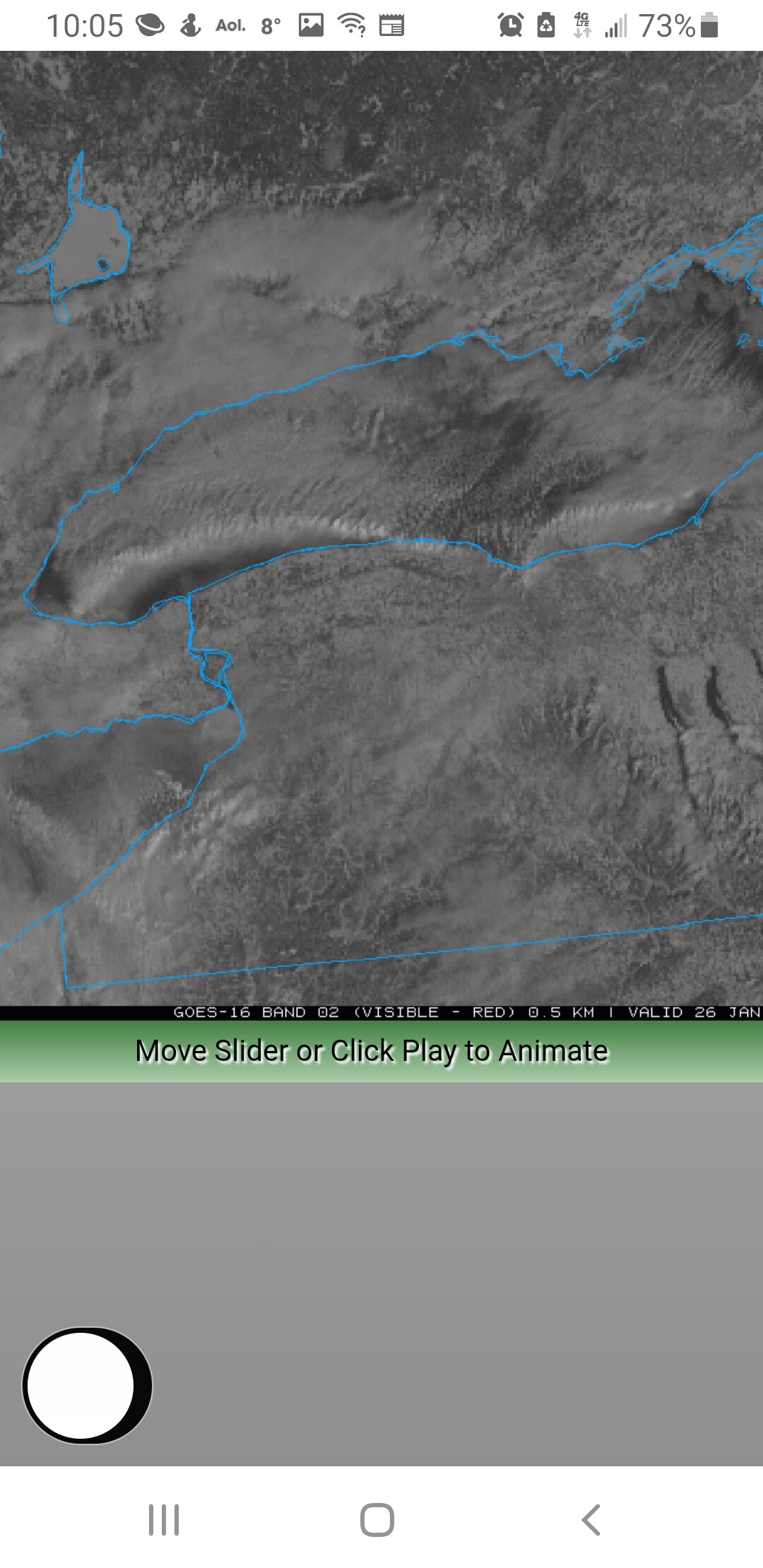
Cool sat loop showing the band pushing the stratus deck apart.
https://weather.cod.edu/satrad/?parms=local-LakeOntario-02-12-1-100-1&checked=map&colorbar=undefined
-
2
-
1
-
-
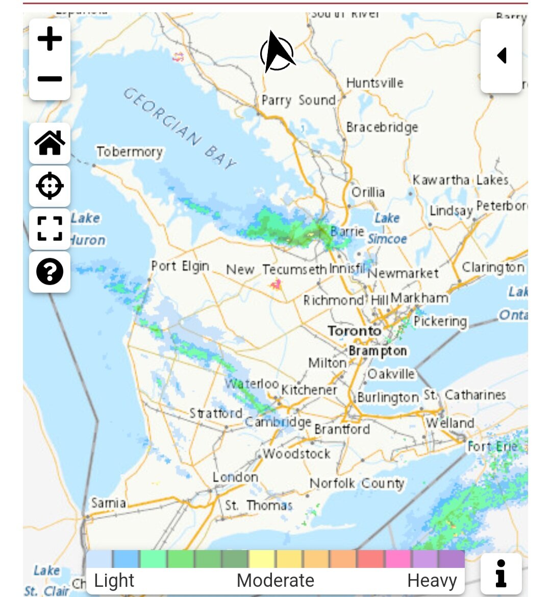
The WWA and snow map seem to favor eastern Wayne and east...boo
-
3 minutes ago, Blue Moon said:
Yep
I walked those paths for 4 years many moons ago.
-
2
-
-
11 minutes ago, Blue Moon said:
It just tapered off about 10 minutes ago as it moved south. Had some really nice rates from 7-8
Are you on campus?
-
Looks like some seeding from GB
-
1
-


Upstate/Eastern New York-Pattern Change Vs Tughill Curse?
in Upstate New York/Pennsylvania
Posted
Nail-biter. Just hoping we can get a nice NE flow off the lake for some fluff. I have family just north of Bangor so I'll get some good reports from them.