

vortmax
-
Posts
4,641 -
Joined
-
Last visited
Content Type
Profiles
Blogs
Forums
American Weather
Media Demo
Store
Gallery
Posts posted by vortmax
-
-
2 hours ago, Syrmax said:
How much for Atlanta?
 Destroys the usual SE Snowbelts.

"The weather enthusiasts questioned the validity of the models, but didn't realize the models were catching onto the Storm of the 21st Century."
-
 2
2
-
-
9 minutes ago, TugHillMatt said:
General consensus of the models is the clipper track continues to our north and anything to our south remains suppressed. We continue to rely on the lakes to provide some snow in some variety.

Boring, but better than nothing.
-
 2
2
-
-
Headline: NCAA changes transgender athlete participation policy amid calls for reevaluation
-
49 minutes ago, Revracer800 said:
Been snowing on and off like a SOB here all morning so far. Huge parachute flakes. Been yet every radar i look at shows nothing lol.
-
2
-
-
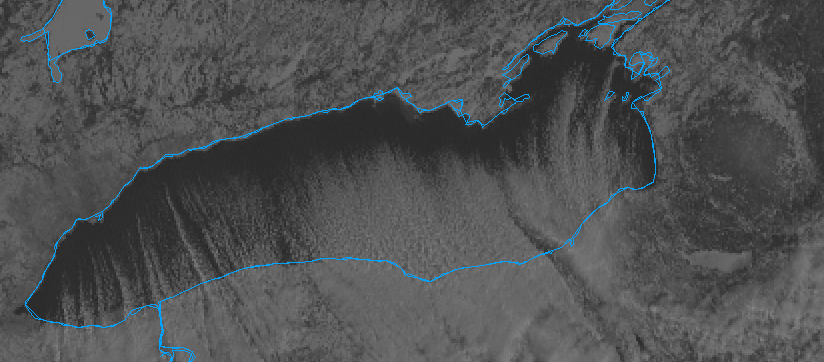
21 hours ago, DeltaT13 said:
Are we looking at the subtle waves moving high above from left to right?
Yes.
-
Pretty cool as a result of the volcanic eruption.
-
1
-
-
Pretty amazing for a south-to-north moving storm to drop over 12" from Cleveland to ENY.
-
1
-
-
17 minutes ago, wolfie09 said:
Well buffalo is having a solid season lol According to GSA they have just under 53" on the year, around 3-4" above where they should be this time of year..
And we are all drooling over BUFs snowfall this year as if it's unattainable - yet only slightly above average. The bar is lowwww.
-
2
-
1
-
-
9 hours ago, rochesterdave said:
Are we ready to do it again?
9 hours ago, tim123 said:Need that nw trend to work for us this time.
Our only hope is that kicker wave to move faster and phase.
-
1 hour ago, Thinksnow18 said:
Picked up another 2 1/2” of fluff from a Lake Huron band just a few hours ago.
Wow, you guys really jackpotted. We didn't get anything last night from the lake other than clouds.
-
2
-
-
51 minutes ago, BGM Blizzard said:
EPS has a smattering of hits with the weekend system. Odds don't look great with the rest of the models being misses but maybe we get lucky.
Control run
.thumb.png.7578f2eab41e0d14df4e4f0d788e0459.png)


Door #29 please.
-
1
-
-
7 minutes ago, TugHillMatt said:
Hmm, hope this happens!
 With
1000-850mb mean flow oriented out of the northwest slowly
becoming west northwest the Winter Weather Advisory for Lake
Effect snow should play out nicely. HREF 1 hour mean snowfall
over the eastern Finger Lakes suggests that inch an hour rates
should be possible generally along and north of the NY Thruway
through around 11pm.
It's been coming down good here. Keep it coming baby!
-
2
-
-
9 minutes ago, PerintonMan said:
Oof, band looks like it's disintegrating over WNY.
Hope the pure lake effect salvages this (and this is why it's dangerous to rely on backside -- it's always hit or miss).
1 hour ago, LakeEffectKing said:For all the Western New Yorkers who don't often get to feel the impacts of a dieing deformation band, you'll notice that, as the storm pulls out radar returns will look weaker but it'll snow surprisingly hard under those relatively weaker returns.
This.
-
1
-
-
1 minute ago, Ottawa Blizzard said:
I checked the traffic cams and the highway was abandoned about 30 minutes ago.
Good, stay home, be safe, and enjoy! The YYZ guys deserve it.
-
1
-
-
1 minute ago, London snowsquall said:
Congrats to the Toronto folks. Most snow storm forecasts for T.O. fail, so nice to see this deliver for you guys. Must be chaos there now. I can only imagine the 400 series highways right now.
Too bad you guys didn't celebrate MLK.
")
-
1
-
-
3 minutes ago, tim123 said:
Roc looks like its getting smoked at the moment.
After a brief lull we have S+ here again. Now the lake is getting involved. Still have soon to be sub 980 LP to walk away. Gonna be a good day. Winds really picking up from the NE.
Love that most of us are getting some love.
-
1
-
-
Just now, DeltaT13 said:
Looks like Roc might be setting up on a pivot point as this starts to pull east!!
Exactly. The winds just turned NNE here and temps dropped 2 degrees in 20 mins. This is the time!
-
1
-
-
1 minute ago, CNY_WX said:

Im literally 2-3 miles east of some steadier snow. That looks to be over Matt.
Just like a LE band. Lol
-
This was always a 2 part storm for us. I'm expecting a better 2nd half!
-
2
-
-
00z 3k NAM still running 3-4mb stronger than actual. 990 LP just south of DC, greatest pressure falls southern NJ.
-
1
-
-
I think my grass will finally be covered.
-
2
-
-
5 minutes ago, rochesterdave said:
992 over Va Beach. 994 over WVA. Pressure falls up through WPA.

00z NAM 3k was 989 @03z. So over amped still. We might be ok.
-
2
-
-
51 minutes ago, BuffaloWeather said:
I just wish everyone here could experience what I did in Nov 2014. Nothing will ever compare to 88" of snow in 3 days. I don't care if it was "fake" snow it had 6-7" of QPF in it when sampled. Walking around in the middle of the 5-6" per hour stuff for hours on end was just incredible, hard to put into words.
Having said that, those rates are increasing and expanding to our south, if that's all snow its about to come down 2-3" per.
I was in Oswego for 4 years so definitely experienced LES in all its glory. Thunder, lightning and 8"/hr rates, once. 12" in 1.5hrs. Only ended up with 36" overnight with that band. Mexico got over 50". 1994, I think.
-
5
-
 1
1
-
-
1 minute ago, BuffaloWeather said:
You're just jealous you don't get hit.
I am, too far east for Erie, too far south for Ontario.
-
 1
1
-

.png.20bbcca7b287ac07e1d33fc61345f428.png)


Upstate/Eastern New York-Pattern Change Vs Tughill Curse?
in Upstate New York/Pennsylvania
Posted
You can see it on the radar loop just spinning in the same location. Wow.