

vortmax
-
Posts
4,641 -
Joined
-
Last visited
Content Type
Profiles
Blogs
Forums
American Weather
Media Demo
Store
Gallery
Posts posted by vortmax
-
-
3 minutes ago, TugHillMatt said:
Ukie looks beautiful for almost all of NY. Sorry, MJO.

Uncle will correct at the last moment.
-
What feature kicks the s/w out of the Southwest?
-
2 hours ago, BuffaloWeather said:
Think the max is around where this guy was. Top of his snowblower is 26"
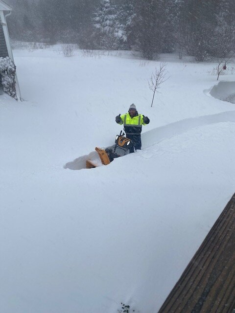
That looks like a solid 10:1 pack.
-
7 minutes ago, tim123 said:
Icon looks like a blend of gfs and cmc.
Perfect.
-
1 minute ago, BuffaloWeather said:
Erie you let me down this year. You had so much potential and only one really good event. Cold and dry was the motto. I'll see you next year.

The sat over Ontario seems to be drying up. Some sunny breaks here now, but got a fluffy inch or so.
-
Just now, tim123 said:
That April 1 at top 3 is truly impressive
Agreed. Massive anomaly.
-
3 minutes ago, tim123 said:
Surprised no march in top 10
Pretty interesting that 9 of 10 are within a 25-day period from late Jan-mid Feb. Obviously the climatologically favored timeframe for a whopper (HECS).
-
6 minutes ago, BuffaloWeather said:
Feel pretty confident Boston will have its biggest ever snowstorm today. Pretty incredible. Logan was over 17" at 2 pm. Likely over 19" by now.
https://www.boston.com/weather/local-news/2022/01/28/top-10-boston-area-snowstorms-on-record/
- Feb. 18, 2003: 27.6 inches
- Feb. 7, 1978: 27.1 inches
- April 1, 1997: 25.4 inches
- Feb. 9, 2013: 24.9 inches
- Jan. 27, 2015: 24.4 inches
- Feb. 17, 2003: 23.6 inches
- Jan. 23, 2005: 22.5 inches
- Jan. 28, 2015: 22.3 inches
- Feb. 9, 2015: 22.2 inches
- Jan. 21, 1978: 21.4 inches
That certainly is a derelict band.
-
 1
1
-
The models are gonna be back and forth with this for the next 3 days...lol
-
We've had 2 biggies here in my lifetime. 1991 and 2003. I was in Nashville for the 2003, but the 1991 one was intense. Killed like all of the white birch in the area - one of my favorite trees!
-
 1
1
-
-
41 minutes ago, Syrmax said:
A lot of "Non-living" Band references to our east. Imagine being on a forum that not only condones but celebrates such behavior. ...
More like a derelict band.
-
1
-
-
45 minutes ago, tim123 said:
Some nice lake effect fluff this am in walworth.
Same here, nothing on radar though. Too bad there wasn't more moisture. IR satellite getting a bit more enhanced.
-
Impressive, most impressive...khhhh phhhh
MAZ007-015-016-019-022-023-290930-
/O.CON.KBOX.BZ.W.0001.220129T0500Z-220130T1000Z/
Eastern Essex MA-Suffolk MA-Eastern Norfolk MA-
Eastern Plymouth MA-Barnstable MA-Dukes MA-
Including the cities of Gloucester, Boston, Quincy, Plymouth,
Chatham, Falmouth, Provincetown, and Vineyard Haven
322 PM EST Fri Jan 28 2022

...BLIZZARD WARNING REMAINS IN EFFECT FROM MIDNIGHT TONIGHT TO
5 AM EST SUNDAY...

* WHAT...Blizzard conditions expected. Total snow accumulations of
  18 to 24 inches with localized 30 inches possible. Winds
  gusting as high as 70 mph.

* WHERE...Portions of eastern, northeastern and southeastern
  Massachusetts.

* WHEN...From midnight tonight to 5 AM EST Sunday.

* IMPACTS...Travel could be extremely difficult to impossible.
  Very strong winds could cause extensive tree damage.

* ADDITIONAL DETAILS...Considerable blowing and drifting snow
  along with near white out conditions at times. Snowfall rates of
  2 to 4 inches per hour is possible at times.
-
 1
1
-
-
11 minutes ago, Syrmax said:
I think we can all agree that we kind of need a 3 day torch to melt some of this snow so that we have room for more. And the sidewalks and parking lots can be cleaned off better to keep everyone safe.
lol. Not.
-
1
-
2
-
-
Just now, BuffaloWeather said:
GFS lol

Step away from the edge.
-
1
-
-
Is 700RH the primary issue why we wouldn't see more of a lake response on the South Shore the next 24hrs?
-
-
That's a 1050 arctic HP bearing down, I bet the CF will be more progressive.
-
1
-
-
1 minute ago, BGM Blizzard said:
12z eps tightened up and is more concentrated on the GL vs 0z.


Would be nice NOT to have a nail-biter for a change...lol
-
1
-
-
I love the anafrontal setups for big snow/ice, but they totally suck when you're on the warm side!!
-
We're almost up to 3" of powder here this AM.
-
6
-
-
18 minutes ago, BuffaloWeather said:
GEFS have either a big snowstorm, ice storm, warm and rain, and everywhere in between. Should be a fun week.
Stormy pattern, check!
-
3
-
-
6 minutes ago, BuffaloWeather said:
Lake effect off Michigan into chicago this morning
Definitely heavier on the north side - Loyola:

-
1
-
-
BOS: You guys driving there are gonna some have fun. Thankfully this is happening on a Sat so people will be home.
...BLIZZARD WARNING IN EFFECT FROM 7 AM SATURDAY TO 5 AM EST
SUNDAY...

* WHAT...Blizzard conditions expected. Total snow accumulations of
  18 to 24 inches. Winds gusting up to 60 mph, possibly as high
  as 70 mph at times across Cape Ann, coastal Plymouth county,
  Cape Cod and Marthas Vineyard.

* WHERE...Portions of eastern, northeastern and southeastern
  Massachusetts.

* WHEN...From 7 AM Saturday to 5 AM EST Sunday.

* IMPACTS...Travel could be very difficult to impossible. Very
  strong winds could cause extensive tree damage.

* ADDITIONAL DETAILS...considerable blowing and drifting snow
  along with near white out conditions at times. Snowfall rates of
  2 to 4 inches per hour is possible at times.
-
3
-


Model Mayhem Snowstorm! 2/2-2/4
in Upstate New York/Pennsylvania
Posted
Good morning everyone! Is there any new energy getting measured in the model that wasn't previously? Something come ashore?
If not, then this may just be a blip.