

vortmax
-
Posts
4,641 -
Joined
-
Last visited
Content Type
Profiles
Blogs
Forums
American Weather
Media Demo
Store
Gallery
Posts posted by vortmax
-
-
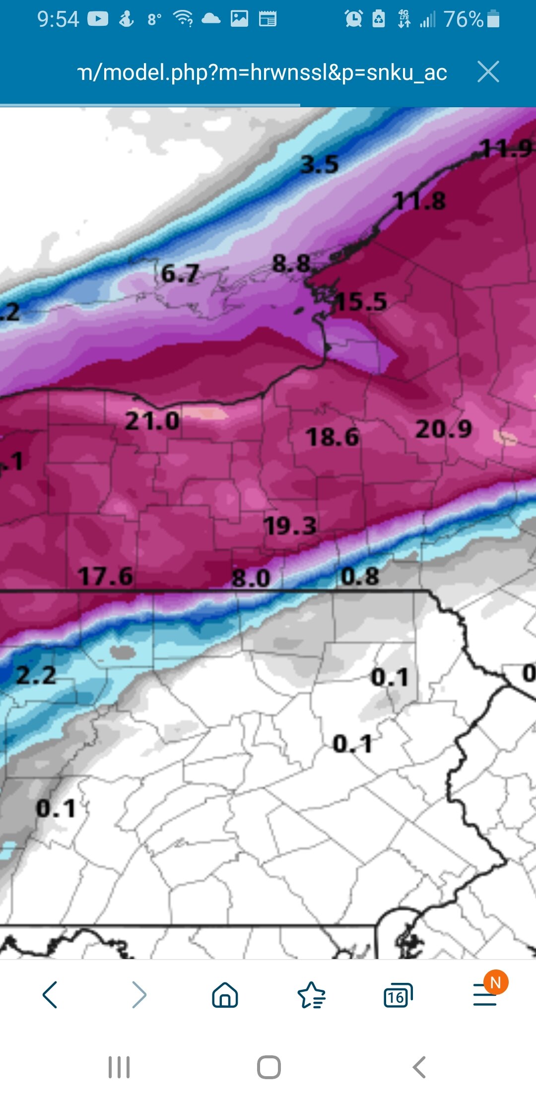
My P&C forecast (aligns with mesos, but not their snow map)...which to believe?? Yet the WSW only goes until 1PM.
This AfternoonSnow before 5pm, then snow showers likely after 5pm. High near 21. North wind 11 to 17 mph. Chance of precipitation is 100%. Total daytime snow accumulation of 2 to 4 inches possible.TonightSnow showers likely before 8pm, then snow between 8pm and 4am, then snow showers likely after 4am. Low around 12. North wind 5 to 13 mph. Chance of precipitation is 100%. New snow accumulation of 3 to 5 inches possible. -
52 minutes ago, CoolMikeWx said:
Someone just posted about this on Twitter that I follow. Lots of energy that needs to phase during this time period but if it does, we would be looking at something large and fantastic.
Sent from my SM-G988U using Tapatalk
The 12z GFS has a similar situation to now just before that final wave runs along the slow moving frontal boundary. Could be a repeat with an added bang at the end. 10 days out is fantasy land though.

-
 1
1
-
-
Check out the cool sat view of Superior. The loop is even better. Multiple mesos...

-
1
-
 4
4
-
-
1 minute ago, BuffaloWeather said:
A general 8-16" across WNY. A solid hit across the area with it being mainly 1:10 ratios.
Still more to go:

-
1
-
-
4 minutes ago, rochesterdave said:
So just around 10-12” in Rochester. A little less than I thought but a decent hit. Good forecast by NWS as usual. NAM 3k 10:1 has been pretty good IMO
It's still going. Meso have 3-8" more in the next 24hr. Still moisture to come in from the SW:

-
2
-
-
1 minute ago, Revracer800 said:
A guesstimate <------ new word lol, of maybe 6-8" here in Hannibal. Each shovel full feels like lifting a house, damn it's heavy.
The heavier the snow, the more you got. lol
-
1
-
-
10 minutes ago, tim123 said:
How much you get vort?
Really hard to tell. It was really windy all night with lots of drifting with this rice-pack. I'd venture to say it's got to be 12ish for sure. Looks like more, but the drifting is deceiving.
-
1
-
-
Just now, lakeeffectkid383 said:
Was just gonna post this. Moderate snow in Boston and best flake size of the whole event now. Not gonna accumulate much with the rate but enough to keep things freshly coated.
Close encounters of the 3rd wave.
-
 1
1
-
-
8 minutes ago, tim123 said:
Looks like a foot in walworth. Was hoping for more. Looks like areas near Lake did get more. Reports are spotty but seeing 11to 13 inch from Greece to Marion
The mesos (HRRR, FV3, and 3k NAM) seem to think we've got another 3-8" to go along the South Shore over the next 24hrs. I used Kuchera as the ratios are certainly above 10:1.
-
1
-
-
 Seems there's still some precip to come through due to a weak 3rd wave. A bit scattered, but may keep frequent snow showers going and a moist atmosphere for some LE... I hope.
-
2
-
-
It's definitely more windy than I expected. Rice snow is drifting alot.
-
Give me some

-
3
-
-
1 minute ago, tim123 said:
Come tomorrow am tha
Isn't it odd how the point and click don't line up with the winter storm warning
That is confusing. Wonder what the process is and which is more accurate.
-
2 minutes ago, rochesterdave said:
NWS not impressed
Don't seem to be, but those snow maps seem to change a lot.
-
1
-
-
Just now, tim123 said:
Really encouraging seeing lake enhancement already.
Here's the loop, can see it clearly.
https://weather.cod.edu/satrad/nexrad/?parms=BUF-N0Q-0-12-100-usa-rad
-
1
-
-
You can see LE 'streamers' coming off LO here. Probably some 1"+ rates under these.

-
2
-
-
Just now, rochesterdave said:
Driving through rainy Syracuse now. Stowe
Must be near Matt.
-
2
-
 1
1
-
-
Temp were around 32 here from 3:30 to 9am, then just suddenly dropped to 29 in the last hour.
-
1
-
-
19 minutes ago, tim123 said:
Arw. What a b
Nasty cut-off in bmg territory. Need bmg to verify. Vort you jackpot with 24 inches. Lol

Bring it.
-
1
-
-
1 minute ago, BuffaloWeather said:
This snow cakes the trees in white, really scenic stuff.
That's my fav.
-
1
-
-
2 minutes ago, rochesterdave said:
You gotta love when NWS bulks up the maps just as the snow begins. Snowing in Pittsford. Gonna be a long drive to VT today. Nothing too treacherous. That comes tonight!
Yes, they are buying into the mesos! Be safe. Have fun. Be thankful it turned out this way. God speed!
-
1
-
-
Just dipped below 36 here. Winds shifting more easterly now.
According to the Tempest stations in the area, wind shift reached Irondequoit Bay.
-
18 minutes ago, DeltaT13 said:
Lots of glancing blows from clippers with deep arctic air/lake effect chances in the next couple weeks. This winter will a solid “B” for me if the latest Gfs run tonight verified verbatim. Quite the pattern we’ve been in for awhile now.
If this current storm give us a foot we’ll have well over a foot on the ground for the better part of the next two weeks which is actually highly unusual even for this typically snowy area; and especially in light of recent climate change. If we keep a foot or better snowpack for 12 days it would be only the third time since the mid 1980s. Quite the feat!
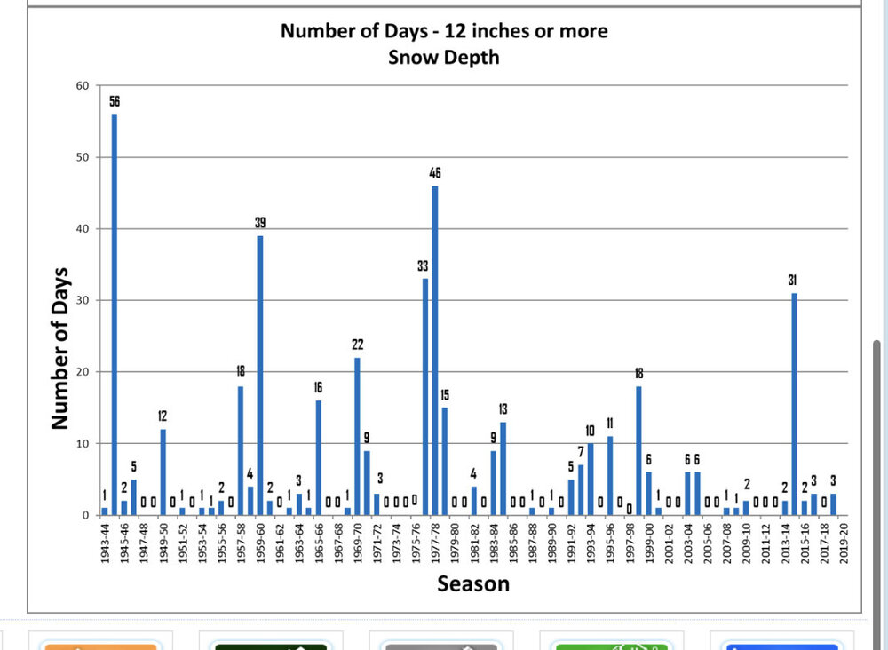
Wow, 56 days in 1945? Dang.
-
1 minute ago, Syrmax said:
WTF are u posting here? Try doing some basic editing?
19 minutes ago, tim123 said:Arws drop 20 to 24 Hamilton to sodus bay.
Should've combined the posts.


Feb 2-4th Snowstorm- Observation Thread
in Upstate New York/Pennsylvania
Posted
Yup