

vortmax
-
Posts
4,641 -
Joined
-
Last visited
Content Type
Profiles
Blogs
Forums
American Weather
Media Demo
Store
Gallery
Posts posted by vortmax
-
-
2 minutes ago, wolfie09 said:

"Baby come back..."
Maybe the icon is on to something.
-
 1
1
-
 1
1
-
-
10 minutes ago, DeltaT13 said:
The ingredients are already onshore so I wouldn't expect massive changes going forward. Seems like the ensembles are for a later further East phase. The trough is slightly positive or neutral as it crosses the Eastern Great Lakes. Not the best for us....perhaps my Vermont trip still has some life in it!
Looking at 500mb the energy is way, way up north, like in the arctic still. How much data is really up there?
-
3 minutes ago, rochesterdave said:
It says: bombs away! Lol. Early phase
Been pretty consistent.
-
 1
1
-
-
The Euro is very positively tilted. Yuk. Really hoping for a big one. When does the energy get onshore?
-
1
-
-
3 minutes ago, wolfie09 said:
.thumb.png.acd63251100388acbb13c9731aaa409a.png)
Toss...bullseye over SYR
-
5
-
-
2 minutes ago, Thinksnow18 said:
I feel like this year the big storms have been modeled well in advance. This is only 4 days out. If the models are keying in now it’s just about the track now.
I don't think all the pieces are onshore yet so sampling is a bit variable still.
-
10 minutes ago, DeltaT13 said:
I'm supposed to be in Vermont this weekend, do I cancel the trip and stay here to ride local? Tough decisions needed in very short order.
That is a tough one. Wait until the very last second to get more model runs in.
-
2 minutes ago, TugHillMatt said:
I almost "liked" this until your last sentence.

Many of us are looking for that last big one, give this winter a solid B+ and move on. I seems to recall a Frozen song...
-
Potential is certainly there. Let's see how this shakes.
-
19 hours ago, DeltaT13 said:
If only this storm was a touch stronger or still deepening and this would have been a very significant event. So close! Still a great day for a wind lover.
Yes, another 5-10mb and this would've rivaled March 2017.
-
Something that strong will have lots of dynamic cooling. Really hoping we get a bonifide blizzard - Spring could come any time after that...lol
-
1
-
-
14 minutes ago, LakeEffectKing said:
It's trying.
That's a big shift from 00z.
-
3
-
-
Lost power. Thankfully it's 70.
-
1
-
-
Just got in the car at the zoo. Winds really starting to pick up!
Getting serious now.
-
1
-
-
7 hours ago, DeltaT13 said:
These anomalous spring wind events are interesting. I assume it’s the juxtaposition between the ice cold lakes and the dark leafless land which creates a huge horizontal temperature delta that must drive large powerful turbulent circulations. Add in some of large snow fields in the higher elevations and dense wooded areas creating additional localized circulations and it should be and interesting day… as long as we get adequate solar heating.
Satellite looks like it may clear out here in a couple hours.
-
1 hour ago, wolfie09 said:
LR Nam wants to hop on the JT express..
.thumb.png.f9cc65e446010b8293b153f0ea6e8ba2.png)
12z RGEM is weaker and further south, but all rain. lol

-
1
-
-
51 minutes ago, TugHillMatt said:
Picked up a surprise inch of translucent fluff overnight.
The stuff that sublimates.
-
12 minutes ago, wolfie09 said:
Lol 939mb..

Don't see that every day...could you imagine??
-
 1
1
-
-
12z GFS definitely more suppressed and weaker with the Monday system. Looks like we'll be on the cold side.
-
1
-
-
Only 1.5" here, but looking forward to March's lion.
-
1 hour ago, rochesterdave said:
I guess it’s down to me and Wolfie hoping on winter.
I'm still in!
-
1
-
1
-
-
6 hours ago, rochesterdave said:
Which of you old-school guys also remembers these cats?
I remember.
-
2
-
-
Don't have a snow board, but it's really close to 11" total this morning.
-
2
-
-
My town got called out on the AFD...famous! Lol
Inversions are low at less than 4kft, but sharper sfc convergence between Oswego and Monroe county has supported concentrated snow showers for areas southeast of Lake Ontario, centered on Wayne county, where local accums of 1-3 inches may accumulate through the night. NYS Mesonet site in Ontario (northwest Wayne county) and the KSDC METAR site in Wayne County along with the BUF radar lower few angles suggest a stronger convergence band in that vcnty.-
3
-

.png.04f24fad6e0213c42e431fc060b64c36.png)
.png.1653ac99336c78f85084bb05ed380868.png)

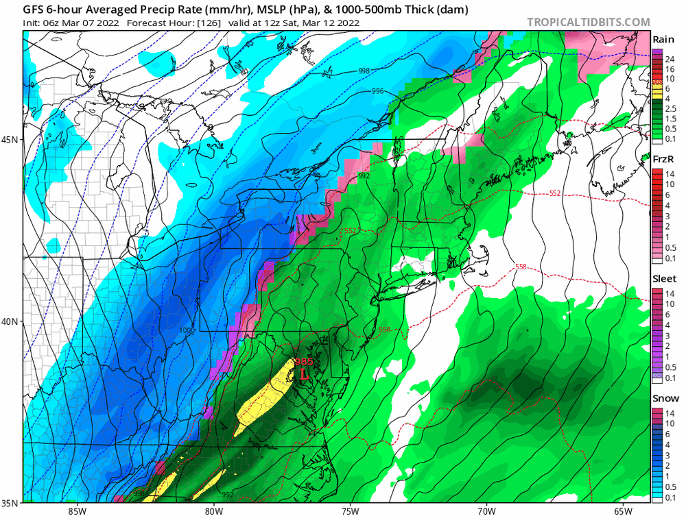
Potential large EC storm/Heavy LES March 11-13th
in Upstate New York/Pennsylvania
Posted
Kuchie only please. We really want to set this one up for major disappointment.