

vortmax
-
Posts
4,641 -
Joined
-
Last visited
Content Type
Profiles
Blogs
Forums
American Weather
Media Demo
Store
Gallery
Posts posted by vortmax
-
-
5 minutes ago, DeltaT13 said:
That storm just east of you is the real mvp so far. Lake Erie marine layer is going to win this battle further west. Looking pretty ragged
I watched it form just to my south, really popped.
-
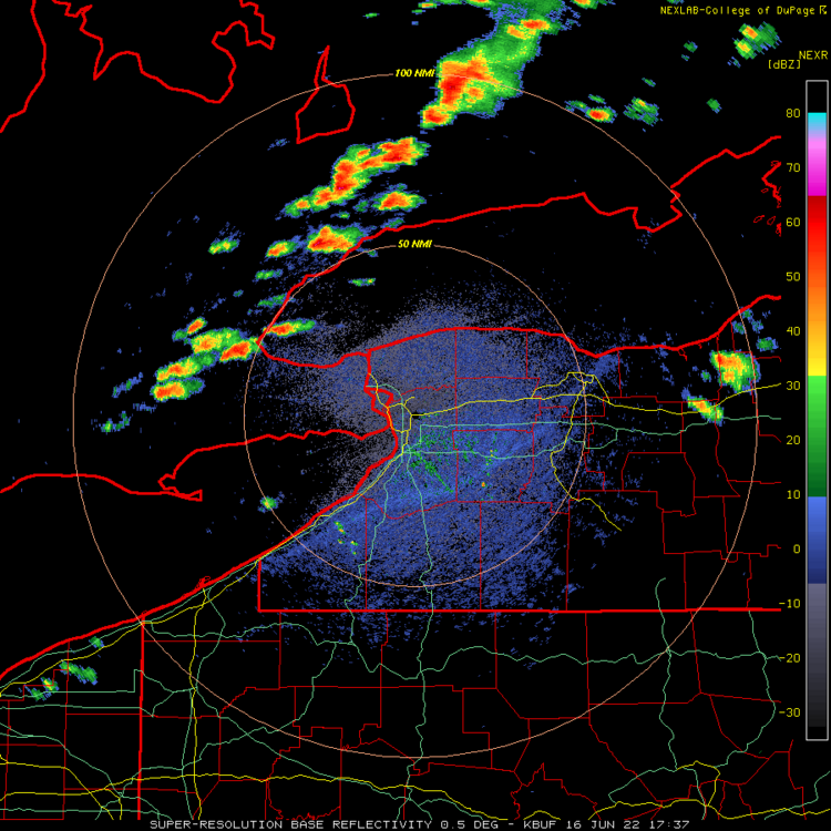
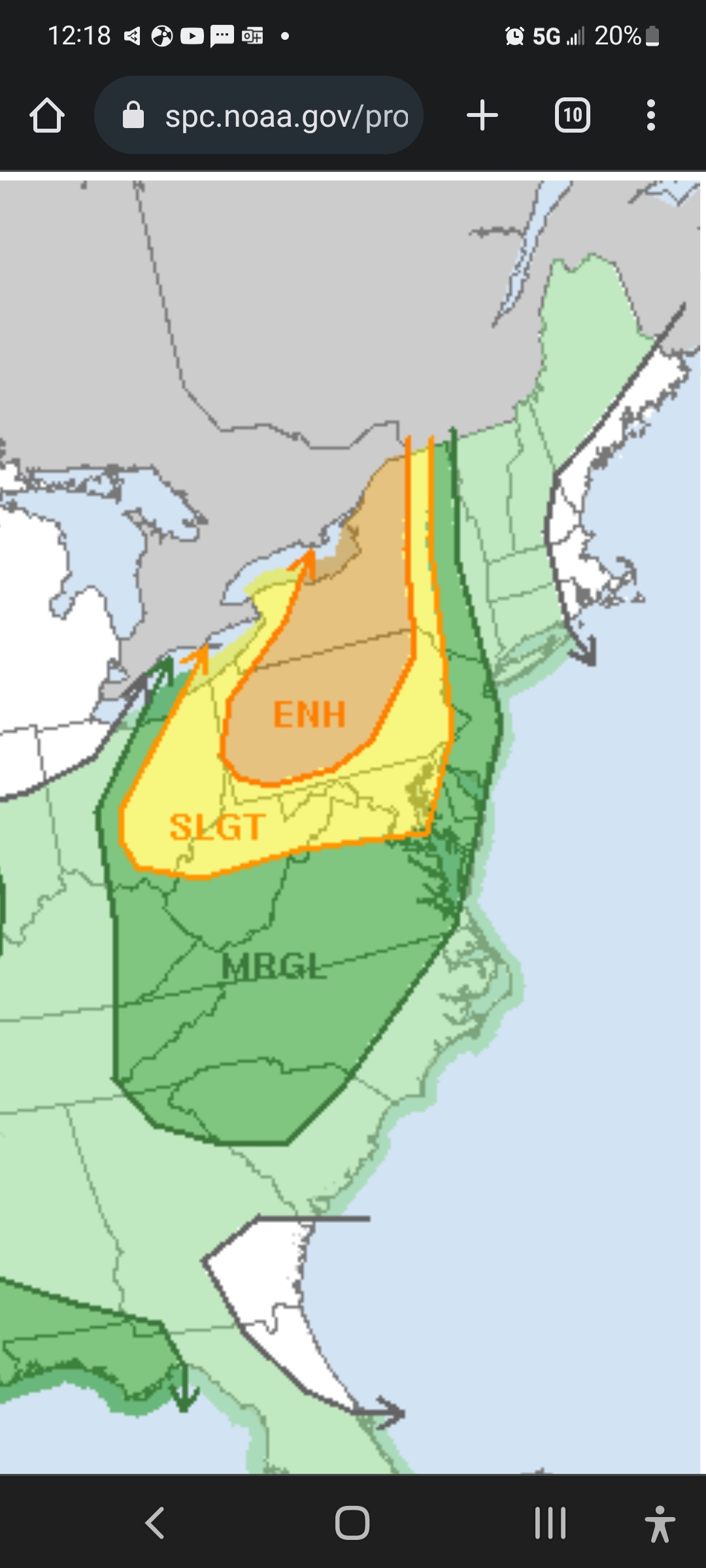
* At 315 PM EDT, a severe thunderstorm was located over Youngstown,
  or 8 miles north of Niagara Falls, moving east at 45 mph.

  HAZARD...60 mph wind gusts and half dollar size hail.
-
-
-
15 minutes ago, DeltaT13 said:
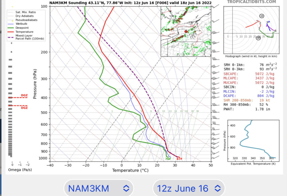
surface based CAPE values are slightly above 5000j/kg. That’s pretty amazing.
Wow, things lighting up over Ontario...
-
-
46 minutes ago, DeltaT13 said:
You’re in a better position than I am. Just outside the typical shadow
We'll see. 4000+ CAPE doesn't happen around here very often.
-
7 minutes ago, DeltaT13 said:
Woke up to a wet bulb of 79 and a dewpoint of 78. Feels insane.
Seems very ripe for severe.
-
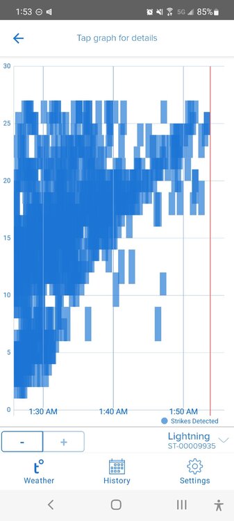
Lots of lightning.
-
 1
1
-
-
Dansville about to get hammered.
-
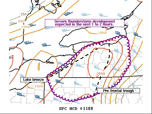
@DeltaT13 Think we're gonna see some nocturnal elevated convection tonight with the warm front?
AFD
Better chances for convection look to arrive tonight as the warm
front starts to enter the region. There should be a round of at
least scattered elevated convection which crosses the area and will
also have to keep an eye on a possible thunderstorm complex that may
drop southeast out of Canada.
-

We take. Great early June weather. Enjoy the weekend.
-
That's all folks...in WNY. The lakes win again.

-
Severe Weather Statement National Weather Service Binghamton NY 348 PM EDT Wed Jun 1 2022 NYC007-PAC115-012015- /O.CON.KBGM.SV.W.0041.000000T0000Z-220601T2015Z/ Broome NY-Susquehanna PA- 348 PM EDT Wed Jun 1 2022 ...A SEVERE THUNDERSTORM WARNING REMAINS IN EFFECT UNTIL 415 PM EDT FOR SOUTHWESTERN BROOME AND NORTHWESTERN SUSQUEHANNA COUNTIES... At 348 PM EDT, a severe thunderstorm was located over Vestal, or near Endicott, moving southeast at 20 mph. HAZARD...Two inch hail and 70 mph wind gusts. SOURCE...Radar indicated. IMPACT...People and animals outdoors will be injured. Expect hail damage to roofs, siding, windows, and vehicles. Expect considerable tree damage. Wind damage is also likely to mobile homes, roofs, and outbuildings. Locations impacted include... Binghamton, Vestal, Johnson City, Endicott, Vestal Center, Endwell, Brackney and West Corners. -
-
7 minutes ago, BuffaloWeather said:

I think the lakes block any svr in WNY again. We need ourselves some nice nocturnal elevated warm frontal convection...that's the best in Springtime...
-
1 hour ago, BuffaloWeather said:
We're going from winter right to summer again. 50s to 80s. Looks to lock in long term too.


This happens, it seems, every May...snow to summer in a week.
-
1
-
-
2 hours ago, BuffaloWeather said:
Yeah KBUF thermometer must be fixed or the urban heating thing is all but confirmed as April was pretty cloudy.
Exactly, that device is surrounded by massive parking lots.
-
1 hour ago, BuffaloWeather said:

Lol, very strange, but the law of averages prevails again.
-
On 4/28/2022 at 8:18 PM, TugHillMatt said:
Indeed! When were you in Brazil?
End of 06. Been a long time!
-
8 minutes ago, TugHillMatt said:
Disagree. The wind was certainly chilly but the late April sun is MUCH warmer on the skin.
If you're protected by the wind, you can definitely feel the higher angle. It's pretty amazing. When I was in Brazil (on the Amazon), the sun was almost overhead and its strength was very noticeable.
-
1
-
-
12 minutes ago, cny rider said:
Our power came back on this afternoon after 2.5 days without.
We have a Honda portable generator that I ran in the evening to power the furnace to warm the house up, provide water, and chill the refrigerator.
It was still damn cold in the house when I got up at 0500 and restarted it.
This was a devastating storm for Otsego County and adjacent areas. Lots of infrastructure damage. Even sadder are the fires burning down homes related to improper generator and other equipment misuse.
Wow. Crazy.
-
Blizzard warnings for Western ND again. Epic Spring for them.
-
3
-
-
All the way done into the WV/NC hills.


Upstate/Eastern New York-Springtime?
in Upstate New York/Pennsylvania
Posted
That cell crapped out. Only a gust came through here. Not even a drop.