

vortmax
-
Posts
4,641 -
Joined
-
Last visited
Content Type
Profiles
Blogs
Forums
American Weather
Media Demo
Store
Gallery
Posts posted by vortmax
-
-
46 minutes ago, TugHillMatt said:
Same here, with big fluffers coming down. Looks like some nice action forming over the '22 Niagara snow belt and moving east.

Huge puff bombs here again.
-
 2
2
-
-
Just now, rochesterdave said:
My snowboard, which was wiped clean, has just over 7” for the event. If I’d kept up with it I suspect I’d be at 8 or 9. Lucky again. What a winter
")
We definitely have 8-9 easy. Just slowed down to flurries, but was pretty heavy for the last 4 hrs.
-
2
-
-
40 minutes ago, wolfie09 said:
They don't seem that impressed..
This is counting some that has already fallen..
Some lake effect expected overnight though..
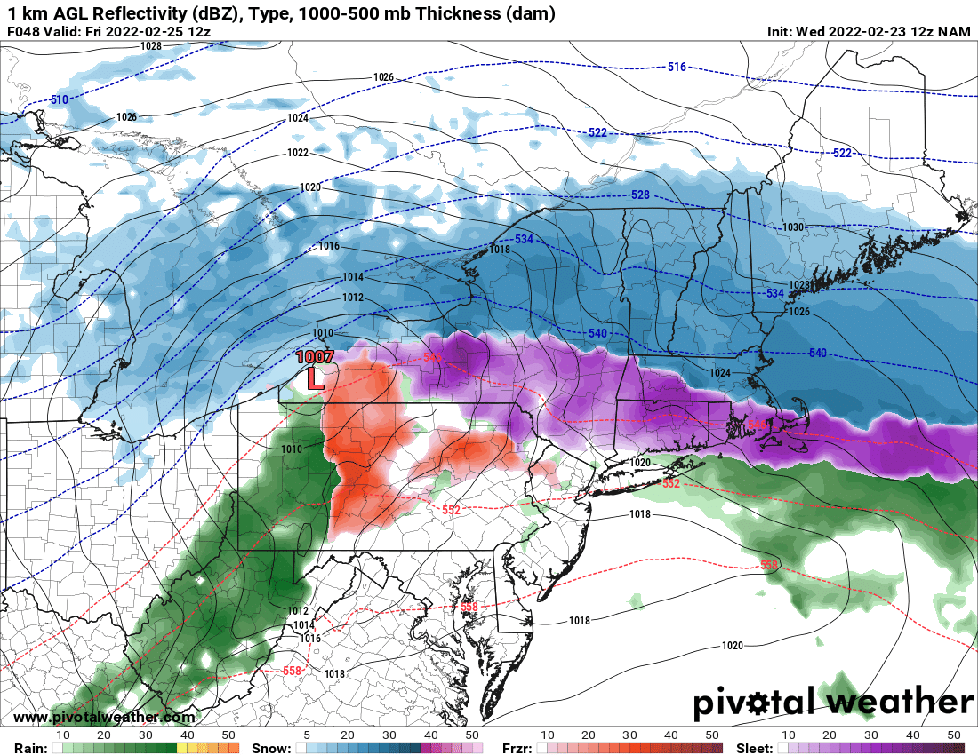
Lake snows will pick up late this afternoon into evening with the most concentrated snow southeast of Lake Ontario between Orleans and Oswego counties. An additional 2-4 inches are possible tonight. Dry air will lowering inversion heights will limit lake snows east of Lake Erie however 1-2 inches are possible through tonight. Lake snows will diminish east of Lake Erie by Saturday morning. Lake snows southeast of Lake Ontario will retreat towards the Lake.thumb.jpg.d449e715b2cfb357e82c388c8bcfddbd.jpg)
Nope, they let WWAs expire.
-
1
-
-
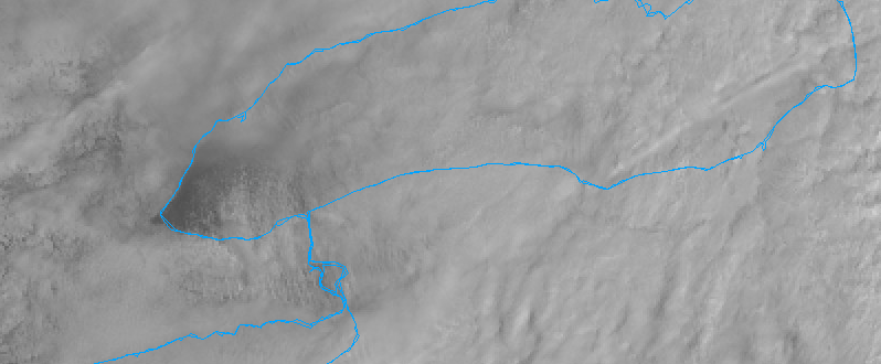
You can see the LE on the west end of LO here:
-
3
-
-
17 minutes ago, rochesterdave said:
Back end rolling in now. Let’s see if it can salvage this.
Winds ENE now...lake should start getting involved soon.
-
-
Def band and LE to the rescue! 4-5" here as well. Winds starting to back.
-
1
-
-
8 minutes ago, wolfie09 said:
Nam last 10 runs, loved the northern primary track..

Seems the GFS/NAM were right.
-
1
-
-
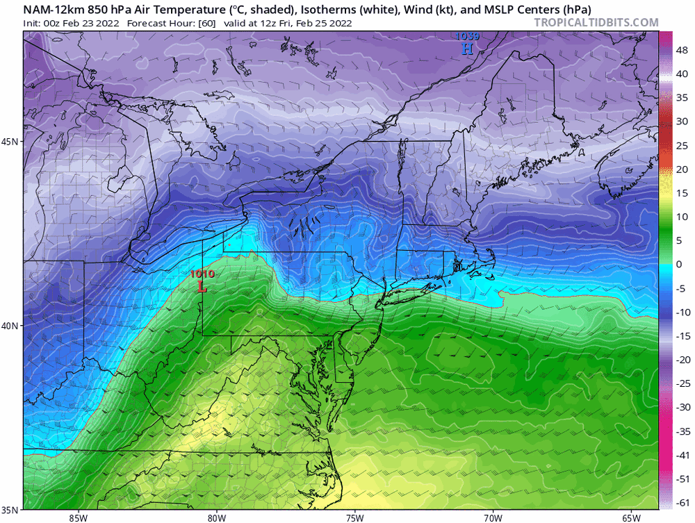
So the mesos/GFS seem to be winning this battle.
-
18z NAM 10:1

-
1
-
 1
1
-
-
-
Quite the spread so close to the game.
-
A blend of NAM and RGEM would be nice.
-
13 minutes ago, TugHillMatt said:
Rgem looks well south of Nam. Like suppressed. Hahaha
Wow, much different and only 48hrs out.

-
1
-
-
9 hours ago, SouthBuffaloSteve said:
hmm.. a SWS for Strong Winds with the cold front passage...
Special Weather Statement
National Weather Service Buffalo NY
1143 PM EST Tue Feb 22 2022

NYZ001>003-010>012-019-085-230700-
Niagara-Orleans-Monroe-Northern Erie-Genesee-Wyoming-Chautauqua-
Southern Erie-
Including the cities of Niagara Falls, Medina, Rochester,
Buffalo, Batavia, Warsaw, Jamestown, Orchard Park,
and Springville
1143 PM EST Tue Feb 22 2022

...Strong Winds Possible Overnight...

The passage of a cold front shortly after midnight could be
accompanied by southwest winds that could gust as high as 45 mph.
The relatively strong winds...being aided by funnelling down the
long fetch of Lake Erie...could then persist into the wee hours of
Wednesday morning.
We actually lost power this AM...
-
1
-
-
7 minutes ago, rochesterdave said:
What Buf was warning us about. A sickening trend. But you can’t discount it.
Might not be terrible as the coastal transfer may keep the South Shore snow, but that is CLOSE!
-
21 minutes ago, TugHillMatt said:
Yikes... 12Z Nams are bringing the mix well north. Hate seeing those doing that, as they are often good with those warm layers.
Yup, it'll be interesting if the RGEM amps as much as the NAM. LP placement between the 2 are the similar, just NAM is ~5mb deeper and takes longer for the shift to coastal.
-
No watches issued for WNY. BUF still must be unsure...I thought they put out watches even if it ends up being a WWA.
-
My bet would be that the primary holds longer. IIRC this seems to have happened quite a bit over the past few seasons.
-
1
-
-
1 minute ago, TugHillMatt said:
Yep! Never ending. Eastern Finger Lakes to Syracuse area.
Hope we get a long-term WNW LE event to bring SYR back to the party - or maybe even a good old fash Miller A.
-
1
-
-
9 minutes ago, BuffaloWeather said:
Might be a dry slot somewhere when that secondary takes over.
Right over CNY. lol
-
 1
1
-
-
What's with this trifecta of storms hitting the UK?
-
Just now, wolfie09 said:

JHW magnet in full effect.
-
1
-
-
1 minute ago, Geez150 said:
If I hit the lotto that's where I'd be headed...one can only dream.
My in-laws live in middle Maine and they have snow OTG from Nov-April, non-stop and very deeps sometimes. Big coastals with sunny days in=between. Even though they average less, it's much more winter-like there. Super cold though. I'd probably like the UP better as you get all the LE and cutters with the arctic air.
-
3
-

.jpg.673d41606ca59ae35f7bb2d5db4ebac1.jpg)


Feb 24-25th Snowstorm- Observation Thread
in Upstate New York/Pennsylvania
Posted
Pouring snow here. Approaching 10" easy.