

vortmax
-
Posts
4,641 -
Joined
-
Last visited
Content Type
Profiles
Blogs
Forums
American Weather
Media Demo
Store
Gallery
Posts posted by vortmax
-
-
Just now, wolfie09 said:
Don't kill the messenger haha
Obviously low confidence forecast though, mainly at 40-60% pops .
 Hugs and kisses wolfie
-
 2
2
-
-
2 minutes ago, wolfie09 said:
Nws doesn't seem impressed.
Again...the bitter cold
airmass will generate some light lake snows south of Lake Ontario
with very minimal accumulations. The snow will be less able to accum
to any degree being in the form of needles and thin plates rather
than fluffy dendrites.
Yet their PNC says 3-7" and map....
 TodayLight snow likely, mainly between 11am and noon. Cloudy, with a temperature falling to around 14 by 5pm. North wind 15 to 17 mph. Chance of precipitation is 60%. Total daytime snow accumulation of 1 to 3 inches possible.TonightA chance of light snow. Mostly cloudy, with a low around 4. Wind chill values as low as -10. North wind 15 to 18 mph, with gusts as high as 28 mph. Chance of precipitation is 40%. New snow accumulation of 1 to 2 inches possible.SaturdayA chance of light snow. Mostly cloudy, with a high near 11. Wind chill values as low as -10. North wind 8 to 13 mph. Chance of precipitation is 40%. New snow accumulation of 1 to 2 inches possible.'
-
 1
1
-
1
-
-
7 hours ago, rochesterdave said:
I actually used to be friends with Kevin Williams, on social media- we’d chat about storms etc, but he blocked me for posting NOA data regarding global warming in opposition to one of his tirades. I totally respect his right to an educated opinion but I can’t stand his smugness and absolute intolerance for other opinions. The guy is a grade A snob.
Great forecaster though. Probably the best in the region.
But you gotta ask yourself what kind of guy throws away multiple high profile positions because he can’t keep politics out of meteorology? The guys a meteorologist- not a climate scientist. Turns out having an extreme right wing position on global warming and it’s causes doesn’t play well when people mostly just want to know if it’s going to rain.
IDK. Maybe it’s principled and he just couldn’t take it but when all of your political views are also MAGA views, you kind of show your hand.
Glad to hear he likes this storm for the region.Can't we all just get along...
")
-
 1
1
-
-
We take pre storm LE Tim/Dave.

-
3
-
-
1 minute ago, lakeeffectkid383 said:
No. That’s a unique new phenomenon called the THM effect, not to be confused with the THC effect. One makes everything melt , the other makes you eat everything in your pantry.
Hilarious
-
3 minutes ago, TugHillMatt said:
For you longer-resident NY residents, have you seen a Low in that position off NJ bring in enough warm air to do such a ridiculous thing in the Syracuse area? It looks like we would be in that heavy snow that's showing up in ridiculous colors, but instead they're both interpreting it as a mix? I'm dumbfounded. The only thing I can think of is what I said earlier with the hellwind from the SE.
Dynamic cooling is your friend. Dryslot is not.
-
2
-
-
1 minute ago, BuffaloWeather said:
ICON


Darth Z Bond again.
-
1
-
2
-
 1
1
-
-
The EPS really tightened up. Nice. Is 18z the first run with some good northern stream vortmax sampling?
-
Perfect place for a late game SE correction.
-
2
-
-
I'm waiting for BUF to get excited about it. Definitely has potential to be the bigger synoptic storm in quite some time.
-
1 minute ago, TugHillMatt said:
I really hope so for you. You could get a triple punch. This NE flow event, then the storm itself, and then WNW flow on the backside.
The Triple Lindy.
-
1
-
-
3 minutes ago, tim123 said:
Meso models seeing ne flow before storm.

Really rooting for this.
-
1
-
-
1 minute ago, Syrmax said:
I need to break out my Kocin/Ucellini books and check that. Certainly isn't a classic Miller B.
I guess there's a quick jump on this frame....
-
1 hour ago, PerintonMan said:
Naive question: how do these 3 models have the lows in completely different places (Harrisburg, Scranton, and well east of NJ), but the precip shield are almost exactly the same?
The first 2 are suffering from convective feedback and placing the LP to the east. If you look at them carefully, you'll see 2 areas of LP on each map.
-
1 minute ago, Syrmax said:
Agree. And there's a full 48 hrs left for model 2nd thoughts to appear. We've all seen big changes w/in 48 hrs too many times to count. In fact, despite op model consistency, we're lrobably violating the axiom to not get too up/down about storms 4-5 days out...
Normally I agree, but as someone alluded to earlier, the 2nd thoughts are always on non-Miller A systems. I think the models have this nailed down aside from some last-minute SE correction (maybe 50-100 miles). I think with LE on the current track, the South Shore will see 24" lollies. JMHO
-
2
-
-
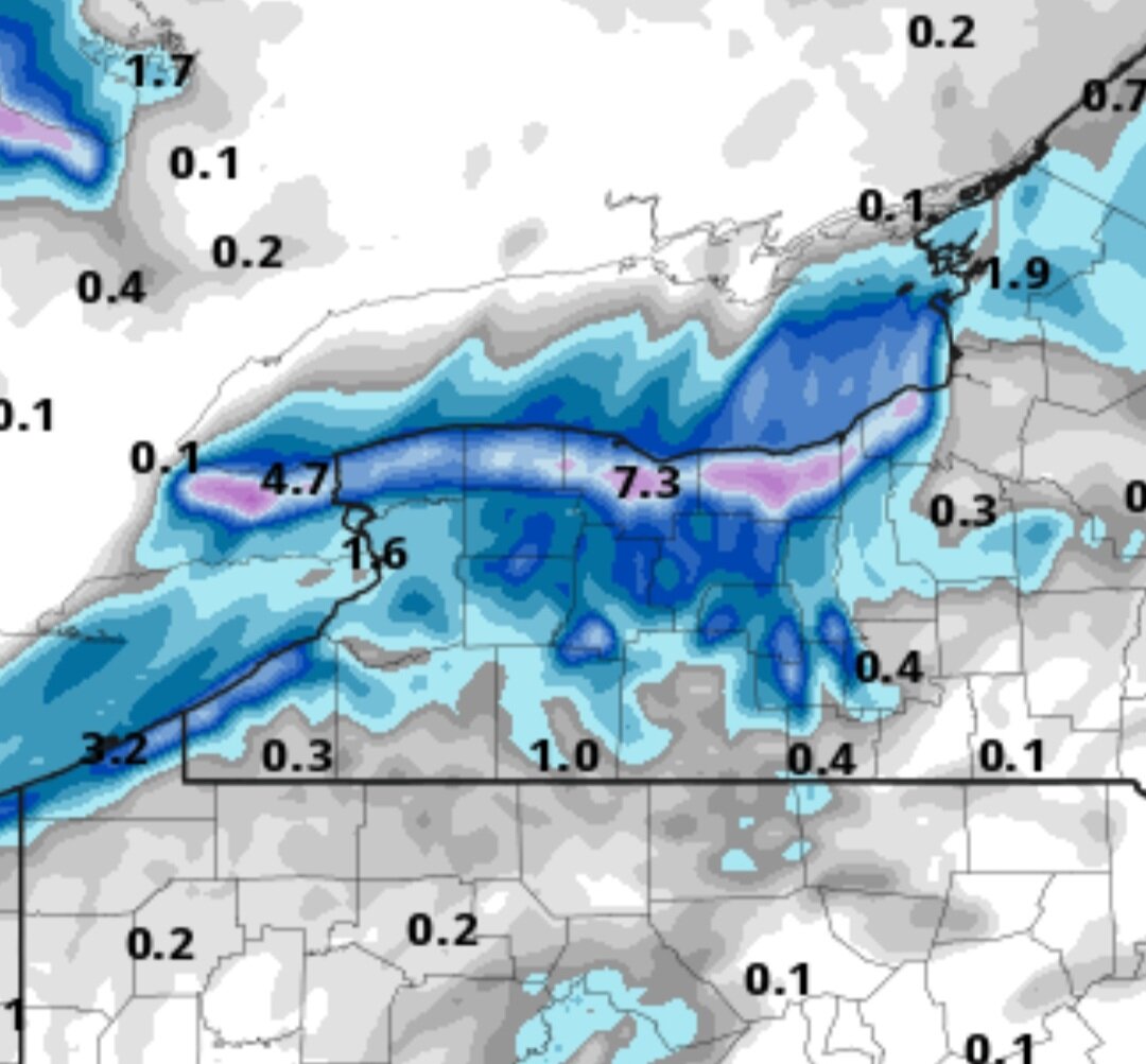
32 minutes ago, DeltaT13 said:
I’ll bet $100 no one is getting anything near 24 inches let alone the low 30s I see on that map. It’s fantasy shit
Stamped and saved... lol
-
2
-
-
Euro 12Z 84hr east by 150 miles, but 3mb deeper. 96hrs east by 75-100mi, but big hit for WNY.
-
Euro is running. Looks the same as 00Z up to 40hrs so far.
-
2 minutes ago, Stash said:
Barring future corrections, I doubt I see 6" this far east, but anything over 2" will be my heaviest "storm" this season. So this should be a net gain, even here. I do agree with your max area though, especially towards SYR.
ENY is a little far east to guarantee 6" with the , but you never know.
-
With a last minute SE correction, I think ROC-SYR are jackpots (w/lollies), but everyone here easily gets 6"+ on either side. Ratios should be 15:1 ish.
-
3
-
-
1 minute ago, rochesterdave said:
That UKIE is perfect! Tick it just a touch east to get more of the forum in. I still think 81 corridor is the sweet spot. 100 miles either side. This one is going to have a bigger QPF field. Just don’t want dry slotting.
But the best part is that GEFS caved!This one is gonna be juicy with it being a Miller A - draws up all sorts of moisture from the Gulf...
-
2
-
-
3 minutes ago, CoolMikeWx said:
Poor nothing for those Mid-Atlantic folks, they just got a nice storm a week ago and we all missed out.

Exactly. DC literally has more snow that I do.
-
Again. I would expect NW trends with a last minute SE correction. Just my take.
-
1
-
-
2 minutes ago, Syrmax said:
The HP is retreating though...not a classic look for a hook low or something forced inland. At this point anyway...
NAO should be slightly negative at this point so hopefully the HP doesn't move too quickly. I just hope we see a stronger phasing to keep this tucked more.

Widespread Snow Potential January 16th to January 18th
in Upstate New York/Pennsylvania
Posted
They are all in on the track, def band, and LE...nice.