

vortmax
-
Posts
4,641 -
Joined
-
Last visited
Content Type
Profiles
Blogs
Forums
American Weather
Media Demo
Store
Gallery
Posts posted by vortmax
-
-
1 minute ago, rochesterdave said:
Yeah. Give me the 981 over Philly. Holy hell would that smoke us
Yes, and we have both the moisture and cold so LE will be a big player for south shore if this materializes.
-
 1
1
-
-
Most are sub-990 as well, which is great.
-
I see a 983mb near Jamestown...lol
-
 2
2
-
-
Look at it this way. At least we have a big synoptic situation to track. This is fun for a change.
-
5
-
-
We're due for a phased apps runner/Miller A. Bring it.
-
3
-
-
Just now, TugHillMatt said:
I would rather take the risk with the Euro being further east than with the further west GFS. Once they start going west, they just keep going and going.
It's all about the phase, about the phase, about the phase...
-
2
-
-
From the HWO:
.DAYS TWO THROUGH SEVEN...Thursday through Tuesday.

A very cold airmass will move into our region Friday night through
Saturday. Wind chills may drop to near 15 below zero Friday night
through Saturday morning.

A storm system is forecast to develop over the southeastern United
States Sunday, then move north along the east coast Sunday night and
Monday. There remains a good deal of uncertainty with the track of
this system. If it tracks far enough west, it may produce a
widespread significant snowfall across our region.
-
That Kuchie maps is hilariously awesome.
-
2
-
-
5 minutes ago, tombo82685 said:
I never said it wasn't a good setup, but the energy diving down is what causes the negative tilt and slings this north imo. If that energy diving down doesn't interact this scoots under as it would just be a big bowling ball low caught underneath the ridge to the north. For example look at 18z eps, the phase is missed and this goes well south of here. That phase is the deal breaker
Or the deal maker! Lol
-
 1
1
-
-
6 minutes ago, TugHillMatt said:
Looks like Euro is showing the whole LO southshore getting some light lake effect action.
Great, maybe my grass will finally be covered for the first time this not-so-young season.
-
 2
2
-
-
Wouldn't it be funny if this ended up being a cutter.
-
8 minutes ago, DeltaT13 said:
I got about 1 inch overnight, but the 3 inches from the front compacted down so I still only have 3 on the ground.
22" on the season.It's depressing to have 2 degrees this morning and rain in the forecast for tomorrow. SMH
Southerly wind, compression, just amazing how quickly the cold air erodes.
-
We need some serious N/S stream well-timed phasing. The odd have to be for a good one sooner than later.
-
This has been the absolute lowest snow winter season so far here. Pretty amazing. Couldn't have more than 8"in total so far.
-
3
-
-
Anyone get anything overnight? We literally got nothing. Some grass still showing. Really disappointed.
-
1
-
-
Already letting up here. Maybe 1.5".
-
-
Getting a good feeling that we might get some nice GB connection to seed.
-
2
-
-
Pushing south on the western end now:

-
4
-
-
1 minute ago, rochesterdave said:
I guess this has to be it. We can hope and pray.
Things are still lit up on the other lakes post front. Lakes are extra warm as well.
-
2
-
-
8 minutes ago, tim123 said:
Nws added in thunder for south shore?
TonightSnow before 2am, then snow showers likely after 2am. The snow could be heavy at times. Some thunder is also possible. Areas of blowing snow before 2am. Low around 5. Wind chill values as low as -10. Blustery, with a northwest wind 18 to 23 mph, with gusts as high as 36 mph. Chance of precipitation is 90%. New snow accumulation of 3 to 7 inches possible.-
1
-
-
30 minutes ago, Buffalo Bumble said:
Man, wish I was here today:
Yes. There's something so peaceful about heavy & deep snow in the woods. I'd love to have a 2nd home/cottage somewhere on the tug for both winters and summers.
-
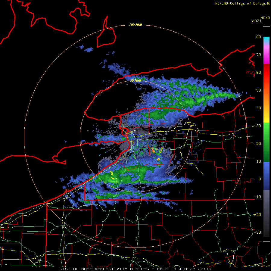
Lake Huron and GB moisture starting to push into LO.
https://weather.cod.edu/satrad/?parms=local-LakeOntario-02-24-0-100-1&checked=map&colorbar=undefined
-
1
-
1
-
-
Pretty colors. lol
The band doesn't have much time to move north according this radar:
Look at that massive band on Huron...dang.


Upstate/Eastern New York-Pattern Change Vs Tughill Curse?
in Upstate New York/Pennsylvania
Posted
I may be mistaken, since it's been a long time since we've had a Miller A, but doesn't the general modelling trends/biases usually start SE, then NW and SE correction 1-2 days before?