

SnoSki14
-
Posts
16,208 -
Joined
-
Last visited
Content Type
Profiles
Blogs
Forums
American Weather
Media Demo
Store
Gallery
Everything posted by SnoSki14
-
This pattern could definitely break towards the warmer side if blocking is weaker. However so far there's no hot weather on the horizon.
-
The famine won't last for much longer.
-
Today def feels more like an onshore flow type day. 55F and cloudy
-
That's a bit of a stretch in late April. It happens but it's rare. That being said once the blocking ends we'll pretty much enter summer so mid-late May onwards.
-
Free market capitalism is just replacing government with corporations except corporations have a profit motive.
-
Looks good in NJ. 60s and dry almost every day.
-
Models showing more onshore influence this weekend. 80s getting replaced with 60s even into NJ. Not surprising, these backdoors generally overperform this time of year. We'll see if we can squeeze 70F tomorrow otherwise it might be a while before we see 70+ temps again.
-
Very sharp gradient Sunday. From 80s to 50s over a short distance
-
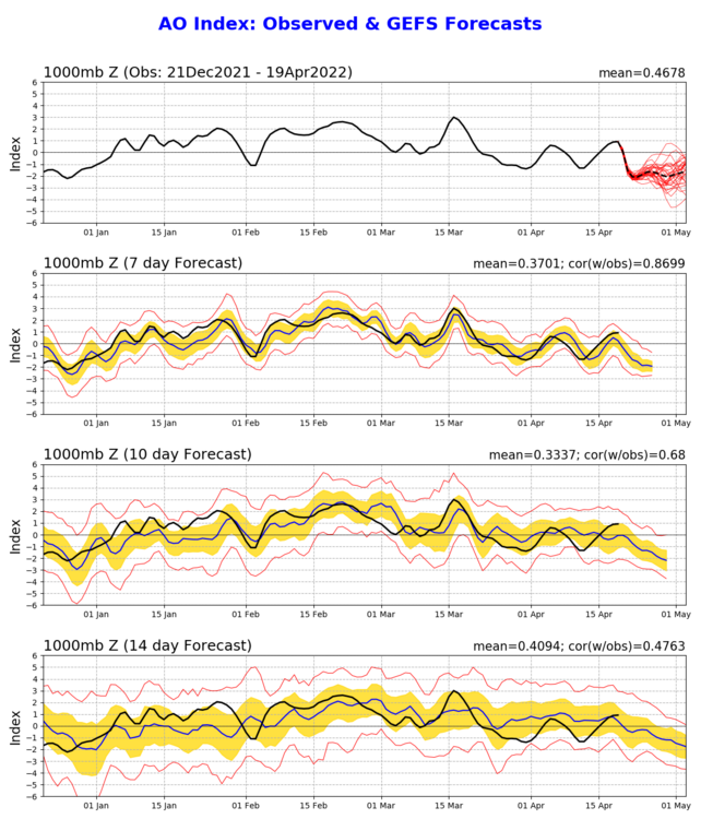
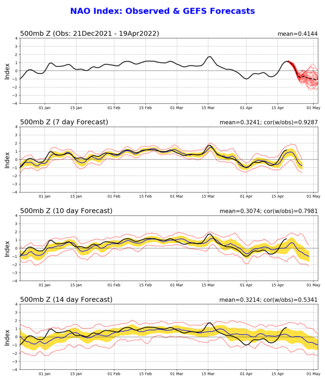
The blocking is actually just getting started late April. The NAO/AO is only now dropping. The weather could still be nice but don't expect very warm weather anytime soon next 2-3 weeks min. 12z EPS suggest more frosts/freezes could be on the table.
-
Where was this during winter. This pattern screams backdoor fronts
-
Not with the blocking pattern. I think NNE may see snow into May this year.
-
Yes true. Personally I'm good with the hotter weather holding off until late May and June. 60s & 70s are perfect right now.
-
Weather-wise it doesn't look too bad though. Mostly 60s for highs with a couple 70+ days and pretty dry. Probably not far from normal overall when averaged over next 2 weeks
-
Some strong backdooring showing up now. 70+ days will be hard to come by
-
Last freeze of the season most likely at 29F
-
I'd rather see the Nam play out then hope for mangled snowflakes
-
Yes but there's a reason why we're getting the spring blocking during spring and most of it stems of AGW impacts
-
Not unusual. April has always been huge for Maine
-
The 80s were well advertised several days out.
-
Top 10 day today as tomorrow's more cloudy/rainy followed by a 3-4 day cool spell
-
Down to 63 from a high of 86
-
That seems unusually high. I don't see any other location hitting that.
-
No, watch now possible
-
Bleh this is just making the allergies and bugs worse. Save it for June
-
Feeling good and summery in the low 80s here in Jersey


