tarheelwx
-
Posts
1,709 -
Joined
-
Last visited
Content Type
Profiles
Blogs
Forums
American Weather
Media Demo
Store
Gallery
Everything posted by tarheelwx
-
GSO? TW
-
That would be brutal. Would hate to see over 1" qpf turn into less than a quarter. TW
-
I think the 06z Euro may be a few hours slower as well. TW
-
He did say he'd see us for the 00z runs. TW
-
Regarding the Icon and the low pressure position. Yes, it looks like the low has shifted south based on the "L" positions. However, if you look at the pressure circles, I think the "L" can sometimes be a bit misleading as they sometimes look a bit off center. Does anyone know how they determine exactly where to put the "L" on the map as sometime it seems to be a bit off center compared to the circle of lowest pressure. Just trying to get educated here. Also, I do see the stronger High and that there's stronger ridging going on east of the mountains. TW
-
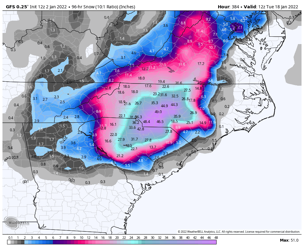
We all laughed when the 384hr GFS from Jan 2nd came through. Sure it was overdone, but I'd have to give it credit for being the first to pick up on this weekend's big dog potential. TW

-
I woke up this morning and the first thing I checked was the 00z Euro. It was pretty disappointing as it showed one of my concerns - the cold air/hp totally crushes things and pushes the storm way too far south. The end result was not a very big storm for anybody. The 06z Euro I get only goes out 90 hours, so it was difficult to really tell where it was headed. Hoping the 12z Euro comes in with a bit more juice and widespread winter weather. TW
-
Dropping in from the Southeast forum as my son moved from NC to Broomfield in December. He's headed to Breckinridge Friday evening and then back to Broomfield Sunday evening. Here's a great free site for the Euro. Not sure if you guys have been using it or now. I use it instead of weather.us site. It gives nice total snowfall maps rather than just snow depth. https://www.pivotalweather.com/model.php?m=ecmwf_full&p=sn10_acc&rh=2021031100&fh=120&r=us_c&dpdt=&mc= TW
-
Actually has alot of ice back to the triad as well. For some fun, check out the mountain west forum. Denver is looking to get a huge snowstorm this weekend. Models have been spitting out anywhere from 10-50". The Denver AFD is good as it features convection, hail, graupel, heavy snow, dry slot, ratios, and even mixing. TW
-
And the Tar Heels streak of consecutive NCAA appearances was rescued over night! TW
-
It’s a really warm snow I believe. 32 or so. I’d really like a legit, decently cold storm. Just something under 30 would be nice. TW
-
I've still got one more good run left. I'm giving it until March 15th. TW
-
February 18-19 MAJOR Ice Storm Threat
tarheelwx replied to NorthHillsWx's topic in Southeastern States
Down to 31.5 in Colfax. Returns back to the southwest. TW -
February 18-19 MAJOR Ice Storm Threat
tarheelwx replied to NorthHillsWx's topic in Southeastern States
Models are definitely trending a touch warmer and drier (though still pretty wet). TW -
February 18-19 MAJOR Ice Storm Threat
tarheelwx replied to NorthHillsWx's topic in Southeastern States
No sun yet in Colfax and 27.9. It sure seems the models are backing off just a bit with fewer of the 1"+ totals showing up. TW -
February 18-19 MAJOR Ice Storm Threat
tarheelwx replied to NorthHillsWx's topic in Southeastern States
Does anyone have ice maps from either/both the 00z and 06z Euro? I’m wondering if it has backed off any. The Icon had quite a precip min over the foothills and western Piedmont. TW -
February 18-19 MAJOR Ice Storm Threat
tarheelwx replied to NorthHillsWx's topic in Southeastern States
If this was a situation where the models were converging on a 0.25-0.35 accrual ice storrm, then it wouldn't be so bad. But, most models have the amounts going MUCH higher. TW -
February 18-19 MAJOR Ice Storm Threat
tarheelwx replied to NorthHillsWx's topic in Southeastern States
I agree, but it seemed the data was overwhelmingly obvious in plenty of time to get it in before the 10pm news casts. I suspect they'll just go straight to a warning. TW -
February 18-19 MAJOR Ice Storm Threat
tarheelwx replied to NorthHillsWx's topic in Southeastern States
I'm really amazed/disappointed/surprised/irked, etc that with such overwhelming model guidance for a disruptive storm, RAH has not expanded the watch area - not having Randolph and Davidson county in there......... what in the world are they thinking? Maybe that's why they are meteorologists and I'm just a hobbyist. TW -
February 18-19 MAJOR Ice Storm Threat
tarheelwx replied to NorthHillsWx's topic in Southeastern States
Icon came in with a pretty serious minimum over the western piedmont and foothills. Not saying it is right, but many areas would be less than 0.50" qpf if it verified. TW -
February 18-19 MAJOR Ice Storm Threat
tarheelwx replied to NorthHillsWx's topic in Southeastern States
Can you elaborate more on the 18z Euro? Any change in temps? Does ice teach RDU or CLT? Triad or thereabouts still with a bullseye? Thanks in advance! TW -
February 18-19 MAJOR Ice Storm Threat
tarheelwx replied to NorthHillsWx's topic in Southeastern States
Any thoughts on why RAH left Davidson and Randolph out of the watch? Out of 6 or 7 models, 100% give warning criteria ice to at least part of the county. Seems like a no brainer to me. TW -
February 18-19 MAJOR Ice Storm Threat
tarheelwx replied to NorthHillsWx's topic in Southeastern States
Pulling for sleet, but heading out to try to find a new bar and a couple of chains for my chainsaw. TW -
February 18-19 MAJOR Ice Storm Threat
tarheelwx replied to NorthHillsWx's topic in Southeastern States
Assuming the 850's are 10c, how would that impact accretion vs a storm with 4c at 850? Assume the surface is 30. TW -
February 18-19 MAJOR Ice Storm Threat
tarheelwx replied to NorthHillsWx's topic in Southeastern States
Poimen showed the 06 Euro with a period of plan rain midday on Thursday before going back to zr. Maybe that mid day break can have a significant impact on total accretion. TW